Getting to the Gasterntal (1540m)
![One Way Street]() Make sure you understand the rules of this special road.
Make sure you understand the rules of this special road.If you are in your own car, the drive to Selden in the Gasterntal is quite simple. You drive to the town of Kandersteg (located south of Thun not far from Bern) and head to the south end of town. At the end of the normal road there is parking with a small kiosk that explains how to drive up into the Gasterntal.
It works like this... If you want to drive up the valley, you buy a pass for 10 Fr. and then follow the instructions carefully. Cars can only go up the valley between x:30 and x:50 of each hour and cars can only go down the valley between x:00 and x:20 of each hour. Ten minutes are left open for the last cars to clear the road. It is impossible for two cars to pass each other on the narrow road which is cut into the cliff. This means anyone not able to follow the instructions will be forced to drive their car in reverse back down the cliff (not something I would have wanted to try). The other option is to take a bus from Kandersteg (train station) up to Selden. That is what most people who were climbing did. As for leaving your car in Selden, it was not a problem. If you don't have a car, take a train from Bern or Thun to Kandersteg and take the little bus to Selden.
Hiking to the Lötschenpass (2690m)
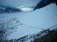
![Lötschengletcher]() The glacier was marked well but all glaciers deserve respect.
The glacier was marked well but all glaciers deserve respect.Once in Selden, simply look for the yellow signs that mark so many of the trails in Switzerland. The sign in Selden puts the hut at 3:45 (but it took us just under 3 hours). You will drop down to the Kander River, cross a cable bridge and head up through the woods past several roaring waterfalls on your left. The trail is very well maintained because the alpine meadows are not only used by climbers and hikers but also the farmers whose sheep and cows graze below the glacier. After 30 minutes (or longer if you are not in a hurry like we were), you will come to the tiny farm/inn known as Gfalp. It is very rustic and worth exploring if you feel like taking a break so early in your climb. We did not stop because we started so late in the day (4:00 p.m.).
Above Gfalp, the trail leaves the steep woods and enters the second alpine environment you will encounter - the "alm". The greens slopes are beautiful and dotted with stunted trees, bucolic cows and shaggy sheep. The trail zig-zags up towards what appears (from below) to be a kind of plateau. This is where the glacier (Lötschengletcher) fans out onto the gravel.
It is important to mention that you will have amazing views, if the weather is good, of the Hockenhorn during most of this time. It looks imposing but it is actually very doable. The locals consider it a "hiking mountain" ("Wegeberg") despite the fact that it is nearly 11,000 feet and appears to be steeper than it really is.
Once you are on the glacier, take care to look where you are hiking. The route is well marked but for a reason. There were some ugly crevasses in the glacier that could swallow a person nicely. Once you cross the glacier you will be on the left moraine (looking up the glacier). You will climb a nice trail to a rocky outcrop a couple hundred feet high. Climb this outcrop to the hut. If you are nervous, use the fixed cables that someone has placed on the more exposed parts of the rock face. We had good weather and so the cables were not needed.
I reached the hut from Selden in 2:55 and my brother-in-law, who likes to hike at his own pace, was only five minutes behind me. We left the valley at Selden at 4 pm and reached the hut in time for dinner at 7 pm.
The Hut (2690m)
![Lötschenpass Hütte]() The hut was expanded in 2007
The hut was expanded in 2007In Switzerland and Austria the huts are usually maintained by a married couple and some younger helpers. This is also true of the Lötschenpass Hut. The hut was being modernized and enlarged in 2007 so much of it was a "work in progress." However, the food was good and there was more than enough room to get a good night sleep. Huts are often overcrowded and that makes for stuffy air and a hot bunk (not in a good way). In 2007, it cost 58 Fr. for the night and that included dinner and breakfast. Visit the
Lötschenpass Hut website for updated prices and information. You can call them at 027-939-19-81 from inside Switzerland for a reservation. Outside Switzerland, use the country code 0041- and drop the 0 from the 027.
The Hike to the Klein Hockenhorn (3100m)
![The Broad West Ridge]() This photo shows the West Ridge (taken looking back from the Summit).
This photo shows the West Ridge (taken looking back from the Summit).Of the entire trip, this hour of easy hiking was the most relaxed and offered the most stupendous views. On the right (South) the
Bietschhorn towers above its neighbors. On the left (which is the North), the Doldenhorn, Freundenhorn (which I climbed in 2003) and the Blümlisalphorn stand in line above the Mutthorn Glacier.
The actual elevation gained from the hut to base of the Klein Hockenhorn is minimal and the ridge is so wide (perhaps 50-100 meters) that one really can concentrate on the views.
We knew the hike up this ridge was not going to be very long so we didn't leave the hut until 8:00 in the morning. It only took an hour to get to the Klein Hockenhorn. You will have gained most of your elevation once you make it to the hut.
The Snowfield and Ridge to the Summit (3293m)
![Almost There...]() Almost there...
Almost there...The remaining 30 minutes of this wonderful climb consist of two parts: The crossing of the snowfield (which was large in 2007) and the summit ridge itself.
The snowfield is not very exposed and a fall would not be catastrophic unless it were very, very icy or the climber were to hit the rocks head first. The slope of the snowfield is 25-30 degrees at most and was easily crossed with poles or an ice-axe. Obviously under different conditions this crossing could be very differnt.
Once you have crossed from the lower right hand side of the snowfield to its upper left, you will find yourself at the base of the rocky scramble that makes up the summit ridge. It is similar in many ways to the scramble near the top of the Habicht but less exposed. It is also similar to the North Ridge of Middle Sister or the summit ridge of the Hohe Geige. Easy blocks and no real climbing (sadly). Still, it is a wonderful, if too short, climb to the summit. I took about 15 minutes from the base of the ridge to the summit cross with plenty of time for photos.
The Summit Cross and Gipfelbuch
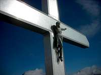
![One-Armed Jesus]() I've never seen this before...
I've never seen this before...The summit itself is a narrow but comfortable ridge of rock. It is not too airy nor too mundane in its proportions.
The interesting part of this summit was, in my opinion, the summit cross itself because it is very rare for a summit cross to depict Jesus. This summit not only had Jesus on the cross
but Jesus also only had one arm. I can only speculate as to how the arm was broken off.
The other interesting tradition, while common to all summits, was the Gipfelbuch or register. This book allows a climber to leave his or her name on the summit with a few comments. The best part is that climbers can read what others have said about the same peak. I discovered that two days prior to my climb there had been 50 cm of new snow (18 inches). That would have made the climb a lot more exciting...
Some Information in German
![Hockenhorn]() Gasterntal ist unglaublich schön und für Europäischen Verhältnissen, sehr wild.
Gasterntal ist unglaublich schön und für Europäischen Verhältnissen, sehr wild. - Entweder zu Fuss oder mit dem öffentlichen Bus ab Bahnhof Kandersteg erreichen Sie durch die enge Chlus das Gasterntal. Tosend stürzt sich hier die junge Kander talwärts. Nun öffnet sich vor Ihnen das Gasterntal in seiner ganzen Pracht. Inmitten hoher Berge empfängt Sie die unverfälschte Natur. Nehmen Sie sich Zeit und entdecken Sie die wahren Schätze dieses wilden Hochtales. Folgen Sie der Kander auf den gepflegten Wanderwegen bis zur Kanderfirn, dem Ursprung dieses Flusses. Die gemütlichen Gaststätten laden zu einem Besuch ein.
Eine Nacht im einsamen Tal wird für Sie zum unvergesslichen Erlebnis. Das Angebot zum Uebernachten reicht vom einfachen Matratzenlager bis zum Hotelbett. Für Bergwanderer und Bersteiger ist das Gasterntal ein Ausgangspunkt für wunderbare Touren.
Comments
No comments posted yet.
")