

-
 15887 Hits
-
 90.48% Score
-
 32 Votes
|
|
Mountain/Rock |
|---|---|
|
|
46.67313°N / 12.18601°E |
|
|
Hiking, Trad Climbing |
|
|
Summer, Fall |
|
|
9314 ft / 2839 m |
|
|
Overview
 Dürrenstein / Picco di Vallandro from north-west (by Andrzej Gibasiewicz) Dürrenstein / Picco di Vallandro from north-west (by Andrzej Gibasiewicz) |
The Prags Dolomites stand out among the Dolomites groups for not being wild and impressive. What comes to mind is the huge alpine meadow of Plätzwiese / Prato Piazza and Pragser Wildsee / Lago di Braies, two tourist attractions good for a stroll or two and both reachable by car. Geologically speaking, however, the group is of great complexity, thanks to the fact that is located at the frontline of the big alpine upheaval. Right to its north, in Pustertal Valley / Val Pusteria, is the fault line between the North African and European tectonic plates, the exact place where the creation of the Alps was most turbulent. Consequently you find all kinds of rock in the range and Dolomite is in the minority. There are some notable exceptions: Seekofel / Croda del Becco, Hohe Gaissl / Croda Rossa and Dürrenstein / Picco di Vallandro.
 Dürrenstein / Picco di Vallandro seen from the north-east
When seen from the west from Plätzwiese / Prato Piazza Dürrenstein fits into the picture of an alpine meadow with surrounding mountains. A slope of some average 30° heads up to the summit and only the topmost part of the ascent trail is considerably rocky. The mountain - even when seen from this side - has several summits - the main summit in the middle, two summit pyramids to the south and a castle-like structure to the north.
 |  |  |  |
But turn to the eastern side of the mountain and the picture changes abruptly. Here you have one of the typical Dolomite Faces: 500m of vertical rock with an assortment of towers distributed over the face. In fact, about a dozen named summits compose the Dürrenstein Massif, making it one of the most complex ones in the area. While all of the towers have been climbed there are only a handful of established routes leaving the mountain open to adventures.
 |  |  |
Dürrenstein can be divided into three sections:
- The southern summits (Helltaler Schlechten /Crepe di Val Chiara)
- Big Pyramid (2711m)
- Pyramid II (2702m)
- Gran Pala di Valchiara
- Torre Viscosa
- Gran Pala di Valchiara
- Big Pyramid (2711m)
- Main Summit
- Main Summit (2839m)
- North-East Summit (2773m)
- Torre di Vallandro
- Torre di Campani
- Torre SUCAI Roma
- Main Summit (2839m)
- Castello Glanvell
- Punta Braies Vecchia (2560m)
- Punta Glanvell (2737m)
- Guglia del Bastone (2450m)
- Torre Sofia (2420m)
- Punta Braies Vecchia (2560m)
Views From The Summit
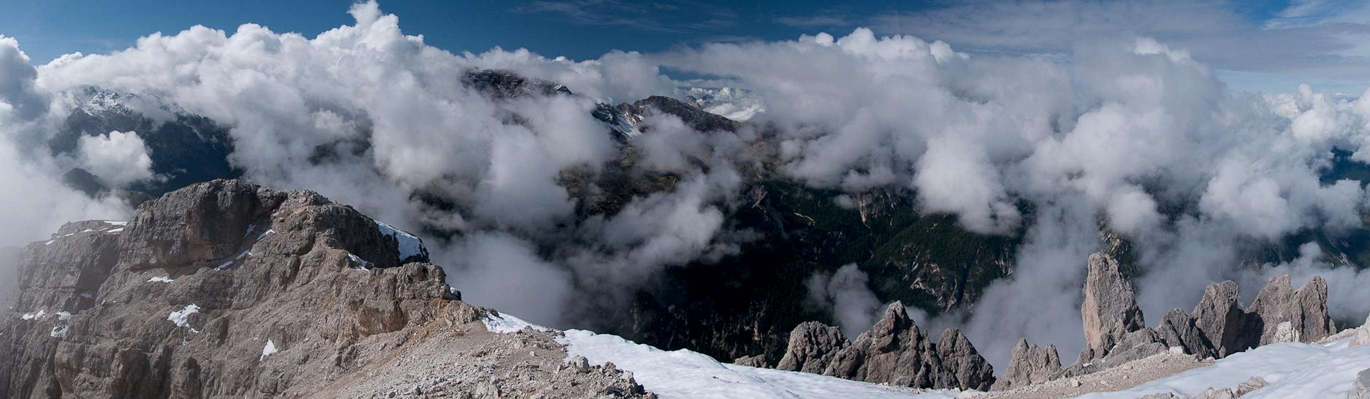  |
Dürrenstein / Picco di Vallandro is one of the greatest lookout peaks in the Dolomites. To the north you see the long chains of the Zillertal Alps and Hohe Tauern while all around rise the compact and impressive Dolomite Groups. Tre Cime / Drei Zinnen and the Sexten / Sesto Dolomites to the east, Cristallo and the Cortina Dolomites to the south as well as the direct neighbours Seekofel / Croda del Becco and Hohe Gaissl / Croda Rossa complete the picture.
 Drei Zinnen / Tre Cime Drei Zinnen / Tre Cime |  Hohe Gaissl / Croda Rossa Hohe Gaissl / Croda Rossa |  Cristallo and Popena Cristallo and Popena |
| Pictures by Romuald Kosina |
Getting There
 Dürrenstein beneath the chains of the Hohe Tauern
From The North
- Take A22 Brenner Motorway to exit Brixen / Bressanone
- Turn off onto SS49 east to Bruneck / Brunico or Toblach / Dobbiaco
From Austria (East)
- Take A12 Inntalautobahn to exit Kufstein.
- Turn onto B178, later B161 south in direction Kitzbühel.
- At Mittersill B161 turns into B108 which heads through Felbertauern Tunnel.
- Take B108 until Lienz were you turn right (west) onto E66 which on the border crossing turns into SS49 to Toblach / Dobbiaco and Bruneck / Brunico.
From Udine
- Take A23 north to exit Carnia.
- Turn off onto SS52 which leads through several detours to Innichen / San Candido
- Turn east on SS49 to Toblach / Dobbiaco and Bruneck / Brunico.
From Venezia
- Take motorway S27 north towards its end near Belluno.
- Turn onto SS51 towards Cortina d’Ampezzo and on to Toblach / Dobbiaco.
Red Tape
 Castello Glanvell left, main summit in centre, Hölltaler Schlechten right
In 1980 an area of 25680ha has been set aside for the natural Park Fanes Sennes - Prags. You are required to treat the Natural Park with care: leave animals and plants in their place, use trails (especially when mountain biking), and take the official open roads with your car.
For more information you can look at the parks official website
Accommodation
 Dürrenstein main summit
For hotels and apartments have a look at the websites of the towns and cities of the area:
Weather Conditions
 Dürrenstein / Picco di Vallandro seen from Monte Piana
For weather conditions you can look at
For the English text you have to scroll down the right frame.
Maps & Books
Books
The Prags Dolomites / Dolomiti de Braies are not as well covered in terms of Guidebooks. The list below offers the German books I know of dealing with the area but there certainly are more, especially Italian ones.
- Dolomiten 5 - Sexten - Toblach - Prags
F. Hauleitner
Rother Verlag
ISBN: 3 7633 4199 4
- Dolomiten
P. Fleischmann
Kompass Verlag
ISBN: 3 8705 1409 4
Sextener Dolomiten extrem - Alpenvereinsführer
R. Goedeke
Rother Verlag
ISBN: 3 7633 1255 2
Maps
The most commonly used maps are the ones by Kompass and by Tabacco. The Kompass one is good as an overview map while the Tabacco one offers more details.
- Bruneck - Toblach / Brunico Dobbiaco
Kompass Map WK 57
ISBN: 3 85491 064 9
Scale: 1:50000
- Dolomiti di Braies / Pragser Dolomiten / Marebbe / Enneberg / Plan de Corones / Kronplatz
Tabacco Map 031
Scale: 1:25000