
|
|
Mountain/Rock |
|---|---|
|
|
47.10004°N / 12.36099°E |
|
|
Hiking, Mountaineering, Ice Climbing, Mixed, Scrambling, Skiing |
|
|
Spring, Summer, Fall, Winter |
|
|
11680 ft / 3560 m |
|
|
Overview
 Rainerhorn, 3560m seen from the west side.
Rainerhorn, 3560m is a mountain located in the nearness of the famous and daily visited Grossvenediger, 3667m. Many climbers climb on its summit when they come back from the trip to Grossvenediger. It is located on the south-east side of Grossvenediger above the glacier basin Oberer Keesboden that is a part of the glacier Schlatenkees. This glacier is located on the north side of Rainerhorn. On the south-west side is the glacier Inneres Mullwitzkees where the normal south approach on Grossvenediger from the valley Dorfertal goes. On the SE side is another glacier called Ausseres Mullwitzkees. This glacier is connected with Inneres Mullwitzkees below the south face of Rainerhorn. On the west side of the Rainerhorn is a important pass and orientation point Rainertörl, 3422m. Then on the west side of this pass is another easily approachable peak Hohes Aderl, 3504m that is to the north connected with Grossvenediger. On the east side of Rainerhorn are two more peaks: Schwarze Wand, 3511m and Hoher Zaun, 3457m. All these mountains are not hardly approachable from the glaciers below but we must be careful on crevasses and on the weather because we will have a big problem if a fog catches us. In the Winter and Spring these mountains are also popular easy skiing destinations..
Rainerhorn is easily approachable over the steep snowy and icy slope from the wide pass Rainertörl, 3422m. For more informaton about routes and approaches check the route overview section. From the summit we will have a beautiful view on the glaciers around us, Grossvenediger and all the giants of Hohetauern group.
Getting There
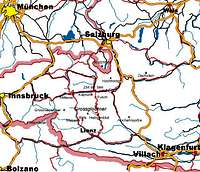 Location map.
Getting there depends on in which valley you want to start your trip.
South approach
For this approach you park the car in the village Hinterbichl, 1329m and you reach the hut Johannishuette, 2121m by walk or you use via Taxi Venediger.
North-east approach
From the Matreier Tauernhaus, 1512m you have to walk 6 km or take a taxi bus (also possible with horses) to the pittoresce hamlet of Innergschloess, 1689m. After a further 1 km walk the even valley ends. Marked route Nr. 902 leads directly via the Alter Prager Huette, 2489m.
 Overview map of Venediger group.
Maps
Alpenvereinskarte (Map of the german/austrian alpine club) 1:25.000 Nr. 36 Venedigergruppe.
Route Overview
 On glacier Schlaten Kees.
South route 2 hours from the Defregger hut over the pass Rainertörl, 3422m and then over the north-west slopes to the summit. Description.
North-east route 3 hours from the Neue Prager hut reaching from the north thethe pass Rainertörl, 3422m and then over the north-west slopes to the summit.
There are some other possbilities also. Each route is only a glacier walk (F). The last slope is a bit steeper.
Red Tape
No restrictions of climbing or fees although the whole area is part of the Nationalpark Hohe Tauern.Camping is not allowed in the National Park, but alpine bivouacs are allowed. In the parking place in Streden you have to pay parking fee. For one day 3 euros, for whole week 9 euros.
Official site of Hohe Tauern national parc
When To Climb
 On the left is Grossvenediger, 3667m, below is Grosser Geiger, 3360m and on the right is Rainerhorn, 3560m.
January to May with Ski, July to September by foot. In summer time the huts are opened and you can get food almost as in a restaurant.
Camping and huts
 Neue Prager Huette, 2796m.
There are some camping places in the villages (Matrei,...).
The huts in the nearness are:
Neue Prager Huette, 2796m.
Johannishuette, 2121m.
Defregger Haus, 2962m.