
-
 11459 Hits
-
 83.42% Score
-
 17 Votes
|
|
Mountain/Rock |
|---|---|
|
|
42.82097°N / 103.58065°W |
|
|
Sioux |
|
|
Hiking |
|
|
4550 ft / 1387 m |
|
|
Overview
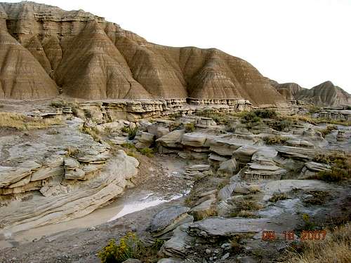 The Bison Trail through Toadstool Geologic Park
Roundtop Peak, while not a serious challenge to climb, is a fun hike because of its close proximity to Toadstool Geologic Park, Cedar Canyon and the Hudson-Meng Bison Bonebed. In one relatively small area, hikers can traverse through ponderosa pine forests, steep walled canyon areas, and stunning rock formations. In addition, the area is rich in fossils and a wealth of interesting rocks and crystals.
 Nearby Dirty Creek Canyon
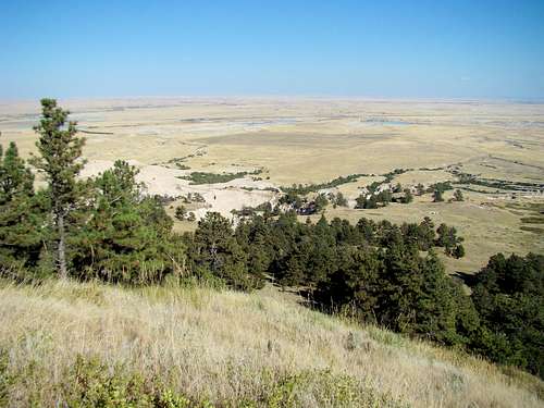
Roundtop Peak's summit offers great views of the Black Hills 30 miles to the north, the Pine Ridge peaks and buttes to the west and south, and prairie to the east. The small summit immediately to the west is Pine Butte. If you are feeling energetic, you can include a hike to the summit of Pine Butte, then go on further west-southwest and hike to the summit of Wright Peak. Eagle Eye Rock is not too much further south for those with a zeal for peak-bagging. These four summits can easily be reached in one day. All four summits mentioned above suffered serious damage in the great forest fires of 2012. The next year, the area was hard hit by Winter Storm Atlas, which knocked down many trees – both living and dead. Roundtop was the least damaged of the four summits and the forest service advises it’s OK to hike any of these peaks now, but that hikers should be cautious about falling dead trees (“snags”).
Getting There
 Bison Trail Panorama
 Road 918
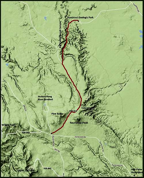
To get to the Roundtop access points, go north from Crawford, Nebraska on Highway 2/71. The Toadstool Road turnoff is just over 4 miles north, and is well-marked. It goes straight west for 2 miles, the sharply turns north-northwest. Six miles from the turn is the turnoff road for Husdon-Meng, and is shown on many maps as Sand Creek Road. That road is also well-maintained and well-marked. FSR918 is about 1 mile past the High Plains Homestead/Drifters Cookshack area. If you choose to access Roundtop by way of Toadstool Park, then skip the Hudson-Meng turnoff and continue north about 7 miles to the Toadstool Park turnoff. At the Toadstool parking lot, trail signs will direct you to the Bison Trail trailhead.
Route Options
 Roundtop Peak Hiking Routes
There are two good routes to reach the summit of Roundtop. Bison Trail Route: Hikers can park at Toadstool Geologic Park and take the 3-mile Bison Trail through Big Cottonwood Creek Canyon toward the Hudson Meng site. This trail is rather unique for the whole state of Nebraska, with incredible scenic rock formations throughout. Shortly after coming out of the canyon, hikers will cross a prairie 2-track road, which is FSR918. At the road, hikers should turn left and hike southeast toward Roundtop, which will be easily visible. Shortly before reaching the forested upper north slope of Roundtop, hikers will approach Cedar Canyon on the left. Caution should be taken about standing too close to the edge, as the sides are not very stable and it is a very long drop down. The road will soon curve almost straight south, exposing several clear off-trail access routes to reach the summit. With the danger of snags, a clear route is highly desirable. The smaller summit to the right (west) is Pine Butte. The elevation gain from Toadstool Park to the Roundtop summit is about 750 feet.
 Roundtop Peak Summit View
Southwest Route: If hikers prefer a shorter and easier route to the top, they can park by the junction of FSR918 and Sand Creek Road. FSR918 runs northeast to the saddle between Roundtop Peak and Pine Butte. This route is only about one mile to Roundtop Peak including your choice of a bushwhack route to the summit. There is about 280 feet of elevation gain on this route. Roundtop Peak lies in the Roundtop Quad. Good maps for the area include the Nebraska National Forest Map that can be purchased at forest service offices in the area. Also, the Motor Vehicle Use Map for the Nebraska National Forest is free and will help you will exploring the area.
Red Tape
All the land is public, so park entrance permits/fees will be your only costs if you bo by way of Toadstool Park. If you hike Roundtop Peak from forest service land, there are no fees. Hudson-Meng Bonebed charges a fee to see their bison bone excavation site building, if one wants to stop for that. Visitors to the area need to remember that it is illegal to remove fossils from the park, but there is no law against photographing them.
Hiking Safety
 After the 2012 Fire
 Cedar Canyon
Though very scenic, the greatest number of risks is focused around the Bison Trail. After any significant precipitation, the bed on the Bison Trail gets very slick in spots where the surface is clay. And there are deep pockets of soft sand that turn into the consistency of quicksand with enough water. There are rattlesnakes in the area. And there are rare sightings of mountain lions also. Ticks are a problem from early March through August. For those using the Bison Trail to reach Roundtop in the heat of summer, plenty of water is extremely important. Reflection from the almost white surface in many places creates very hot conditions in the bottom of the canyon. As previously mentioned, there are still risks for falling dead trees, especially on windy days.
Camping, Lodging & Resource Links
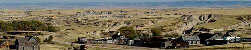 The High Plains Homestead
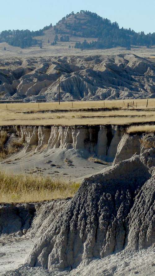 Roundtop Peak
Camping is available at Toadstool Geologic Park. Self-pay stations are located there. There are vault toilets and no showers or running water – you must pack in your own water. The nearest camping elsewhere would be in Crawford, 19 miles away, and at Fort Robinson, 2 miles west of Crawford. There is also some lodging just a few miles away at the High Plains Homestead - very rustic in a frontier theme. The Drifter Cookshack there is the closest place to get an excellent meal. For more information on any of these options, click on any of the links below:
Toadstool Geologic Park Information (308) 432-0300
High Plains Homestead / Drifter Cookshack & Bunkhouse (308) 665-2952
Fort Robinson State Park (308) 665-2900
Crawford Chamber of Commerce (308) 665-1462