
-
 30751 Hits
-
 82.48% Score
-
 15 Votes
|
|
Mountain/Rock |
|---|---|
|
|
37.78336°N / 118.34321°W |
|
|
Mono |
|
|
13559 ft / 4133 m |
|
|
Overview
Mt. Dubois is in the desert northeast of Bishop, California. It's quite remote, and seldom climbed. Plenty of solitude! In a tiny spiral notebook in the ammo box on the summit, only 4 pages have been used in over 2 years.Dubois is probably the flattest Thirteener I ever climbed, or ever will climb, but it's (tied for) the second highest peak in the White Mountain range. It ranks in the 50 highest peaks in California. It's so flat, you can't see the adjacent valleys on the east or the west, nor the more often climbed Montgomery and Boundary peaks at the north end of this range. Looking at the Pellisier Flats, north from the summit of White Mountain, Dubois is virtually indistinguishable from other bumps along a flattened 3 mile long 13000 foot ridge. It is one of the northernmost, and the second highest of the peaks on the Sierra Club Desert Peaks Section list.
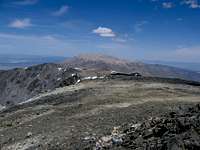 Dubois from White
From the summit, there are beautiful panoramic views of the Sierra Nevada range in California, and the Great Basin in Nevada, but you might want to allow time to roam around the plateau to get a complete view of the more local area. There is an unnamed summit exactly the same height as Dubois just 2 km to the north. The northern summit "13559" is less than 200 ft. up and 1/2 mile off your route if you come up Middle Creek/Chiatovich Creek ridge, and I assume it would have a view of the Jumpoff, Montgomery and Boundary to the north of it.
Getting There
Most easily climbed from Middle Creek, on the northeast, starting in Nevada. See the approach in Google maps here or open this file in Google Earth, or see this map picture with a verbal description.For an approach to climb Dubois from the west, see Larry Tidball's trip report at http://angeles.sierraclub.org/dps/archives/dps00426.htm
It has also be climbed various ways from the south (including a dayhike traverse (see picture at right) or as a backpack from White to Boundary, and from the north on a traverse from Montgomery.
Red Tape
None! There used to be a little kiosk where you could write a Boundary Peak Wilderness trip report at Morris Creek, but apparently it was torn down by vandals and used as firewood in the summer of 2007.Note that the 4WD road along Middle Creek appears to extend into the Boundary Peak Wilderness, but the boundary is labeled "indefinite" on my 1994 USGS topo. The 1st "Boundary Peak Wilderness" sign posted is on the trail just after the end of the road. The INYO NF Visitor's map shows the same boundary, but makes no mention of "indefinite". I hope I wasn't violating the wilderness! This wilderness is entirely in Nevada - its western boundary is the California/Nevada state line.