Your object was successfully created.

-
 18056 Hits
-
 92.32% Score
-
 38 Votes
|
|
Route |
|---|---|
|
|
41.83330°N / 111.7017°W |
|
|
Hiking, Scrambling |
|
|
Spring, Summer, Fall, Winter |
|
|
Most of a day |
|
|
Class 2 |
|
|
Overview
Green Canyon is the most popular route up Mount Jardine. The elevation gain is gradual even though it is a long canyon. Its name originates from the healthy growth of green vegetation that is located in the canyon. The trail through the canyon is in good condtion to about 8,500 feet. Then is begins to fade away. At the junction that is located between Mount Elmer and Mount Jardine you will have to leave the trail and climb up the ridge between the two peaks. Mount Jardine in located to the south. There was some water in the canyon but I would carry it all with you anyway since it was mostly dry. In my opinion, this is the best route to use if you want to climb Mount Elmer and Mount Jardine in one day. It is also the safest route to use in winter.
Getting There
Drive on I-15 north of Brigham City and take exit 362 (US-91/Logan). Keep driving on US-91 through Sardine Canyon. After 25 miles US-91 will merge into Main Street in Logan. Continue driving to the city of North Logan. Turn right at 1900 North and go passed K-Mart. Drive east and the road will turn into 1900 North. Keep driving on this road and there will be a parking lot about 1 mile or so near the mouth of Green Canyon. This is the winter trailhead and any vehicle can be driven here. From July to November 15, a dirt road continues for 3.75 miles to the summer parking lot. It is in good condition but some cars may find it a little rough. There are several side roads that go to quarries along the way. There was also a restroom near the trailhead.
Route Description
 Green Canyon
 Green Canyon
The upper trailhead is located here: (41° 47' 41.3" N, 111° 43' 06.5" W). The trail starts at the opening near the fence. There is little elevation gain on this part of the hike which is on a nice maintained trail. You will be in the forest for much of this time. After 1.5 miles you will walk by the Mount Naomi Peak Wilderness Sign. You will be following the dry creek bed on this part. The trail goes to the left side of the canyon until you are higher up. Some limestone cliffs will be on the right side of Green Canyon. The canyon starts to get narrower as you gain more elevation.
 Mount Jardine
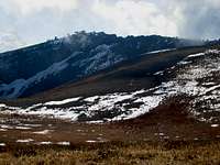 Mount Jardine
The trail goes near a trough with water coming out of a pipe that is located here: (41° 49' 20.1" N, 111° 41' 33.4" W). It was full of water in October but may have less in summer. This was the only significant water source I saw in the canyon. There is an unmarked trail junction farther ahead. A smaller trail goes straight ahead. The larger more obvious trail goes up a series of switchbacks. Take the maintained trail up the switchbacks up the hillside. There will be a sign pointing toward Beirdneau Peak on the right and you will be right beneath the mountain. I didn’t see a trail so it is just an indicator of where you can climb up the mountain.
 North Ridge
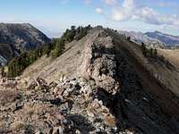 North Ridge
A trail junction will be ahead that is located. It wasn't marked with a sign when I was there. This is the junction that is shown on the map that splits into two. The trail on the right climbs up higher and goes in the direction toward Mount Elmer. You can climb both mountains from this trail which is what I did. Both trails go toward the ridge that is located between both peaks. Take the main trail on the right that goes north. You will come to a sign that says Beirdneau Peak and points right. The route to Mount Jardine goes left. Climb up toward the saddle to the west.
 Summit
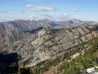 Mount Jardine View
Hike toward the ridge that is located between Mount Elmer and Jardine. Mount Jardine will be to the south along the ridge. Follow the ridge south toward Jardine Peak. The mountain has a row of dark cliffs on its north face so it is easy to recognize. Climb up the ridge that is located north of the mountain. The ridge will become more defined as you get closer. There are two ways to get to the summit. In my opinion, it is easier to stay on the ridge the entire time which involves some scrambling. The other way is around the right side of the ridge until you are below the top where you can climb up a talus or snow filled gully. The summit has a large cairn on it.
The summit of Mount Jardine is located here: (41° 50' 00"N, 111° 42' 08"W). The view from Mount Jardine includes the summit of Mount Elmer which barely reaches over the ridge to the north. The highest peaks in the range can be seen in the distance. They include Naomi, Doubletop, and Cherry Peak. Flat Top Mountain will be to the west and it is easy to see how it received its name from this vantage point. To the south, you can see Logan Peak. Beirdneau Peak looks rather diminutive below Mount Jardine. Cache Valley can be seen to the west.
Descent: The standard descent is down Green Canyon. I took a short-cut down the canyon that is located east of the summit. It didn't seem too bad even though it was a little over grown. By the time I had reached the main trail, my pants were covered in stickers and thorns. This is the only downside to that short-cut.
Traverse to Mount Elmer: If you decide to climb Mount Jardine and Mount Elmer in the same day, add 1 to 2 hours to your hike. I found the ridge between the two summits to be quite fun. There are a few false summits along the way. The west side of the ridge drops down into Birch Canyon for several hundred feet down vertical cliffs. The summit of Mount Elmer is located here: (41° 51' 11"N, 111° 41' 14"W).
Summer: Distance is 6.35 miles from the upper trailhead to the summit with 3,600 feet elevation gain.
Winter: Distance is 10.1 miles from the lower trailhead to the summit with 4,875 feet elevation gain.
Essential Gear
Summer: Bring regular day hiking gear including food, water, warm clothes, hiking boots, and topomap.
Winter: Green Canyon is the standard route in winter. Kelsey’s Utah Mountaineering Book describes climbing the mountain in winter. Snowshoes or skis will be needed because there will be deep power in the canyon. The ridge will probably be more hard packed due to wind. It is a long day to climb the mountain in winter. Ice ax is recommended and crampons are optional.
You can shed a few miles off by staying at the yurt near the upper trailhead. The Green Canyon Yurt is assembled and dismantled at the beginning and end of winter unlike the other yurts that stay up year round. Each yurt holds a wood-burning stove, a kitchen and sleeping bunks for as many as 12 different people. Renting a yurt costs anywhere from $50-$170 a night, depending on the day of the week and the number of days you are staying. USU students receive a discount off the basic rate. Here is more information on the Green Canyon Yurt