Plans for a Fall Day
Our ambition was a 7 peak day in the crisp November air of southern California’s San Jacinto Wilderness Area. The outing was conceived by SPer Travis (Linds). He solicited takers - and there were several - but for various reasons, only Travis and I ended up on the outing. We planned to do a loop from the top of the Palm Springs Tram (8,240’) going west in a counter-clockwise direction. In order, we would climb Cornell Peak (9,750’), Miller Peak (10,400’), San Jacinto Peak (10,834’), Folly Peak (10,480’), Drury Peak (10,160+’), Jean Peak (10,670’) and Marion Mountain (10,320’). Travis downloaded a route for us on his GPS and we were set.
We left my house in South Pasadena promptly at 5:30 a.m. and breezed to the tram with time to spare to catch the first tram up the canyon at 8 a.m. At the tram, we ran into a group of Russians (now living in the States) I had met the previous weekend on a climb of Mt. Baldy via Register Ridge. They had been an exuberant bunch and I was happy to run into them again.
When we got to the top of the tram, it was an invigorating 35º F. We hiked the short distance to the Ranger Station in Long Valley to pick up our self-issued permit and we were on our way.
Striated Rock to Cornell and Brush to Miller
![The Triangle Peak: Cornell]() The distinctive Cornell Peak
The distinctive Cornell Peak
After a short distance on the trail towards Round Valley, we veered off to follow the creek on its north side for a ways and then turned northwest up Cornell’s south slope. We encountered beautiful, striated rock on the ascent and enjoyed immensely this stretch of the climb.
![Ascent to Cornell Pk (9750 )]() Ascent to Cornell Peak
Ascent to Cornell Peak
The summit block of Cornell was a real treat. It has to be one of the best in southern California. It took a little bit of effort and a smidgin’ of daring to scoot out to the highest part of the summit in the face of strong, cold winds wanting to knock us off balance.
![SPer Travis (Linds) on Summit Cornell Pk (9750 )]() Travis on summit of Cornell
Travis on summit of Cornell![Mtn Impulse on Summit of Cornell Peak (9750 )]() Me on summit of Cornell
Me on summit of Cornell
The top of the route we took climbing down Cornell’s south slope also required some care. Travis went first and I noted that, because he is quite a bit taller than I am (I am 5'9"), footholds that he could reach in one move, took me two moves in some cases and extra time to find those intermediate holds.
![Route down from Cornell Pk (9750 )]() Our descent route from Cornell
Our descent route from Cornell
At the bottom of the slope we headed west and came upon a trail with a few long switchbacks that got us to the south slope of Miller Peak. There was some bushwhacking on the way up. However, this cross-country route to Miller is a lot more pleasing than simply stepping off the trail when approaching Miller from San Jacinto Peak. The winds continued their cold assault, and we found a sheltered spot below the summit to have a snack.
San Jacinto Peak and Folly's Summit Edifice
![San Jacinto Pk (10,834 ) from summit of Miller Pk (10,400 )]() San Jacinto Pk looking west from Miller Pk
San Jacinto Pk looking west from Miller Pk
We had started out from the Ranger Station at 8:40 a.m. and had done our second peak before 10:30, so we felt we were on pace to finish our loop well before dark. From Miller, we took the trail all the way to San Jacinto Peak. This was the only leg done all on trail today. On reaching the cabin below the summit, we ran into my Russian friends who had come up the trail from the tram. We completed the short distance to the top and enjoyed the views. Because of the winds, visibility was unparalleled.
![Russian Climber near San Jacinto Peak (10,834 )]() Russian Climber near San Jacinto summit
Russian Climber near San Jacinto summit![Travis on San Jacinto Peak]() Travis on San Jacinto summit
Travis on San Jacinto summit
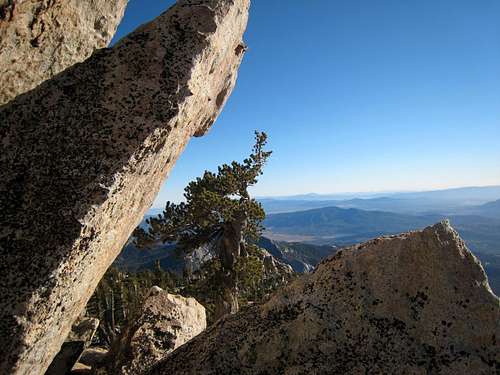
Our Russian friends were just approaching the summit as were leaving and we bade them farewell. This was the only summit where we saw other hikers today. Our next stop was Folly Peak. It lies northwest of San Jacinto Peak and you can see it from San Jacinto’s summit sitting toward the end of San Jacinto’s long northwest ridge.
![View towards San Jacinto Pk from near Folly Peak]() San Jacinto's NW ridge dropping to Folly
San Jacinto's NW ridge dropping to Folly
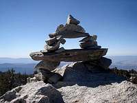
It was a fun scramble down the ridge, over and around rock, and through the trees. There were a couple of false summits along the way, but at last we came to the last saddle and then a short ascent to Folly’s summit. The summit of Folly is not easily missed as it has an elaborate rock edifice marking the high point. If anything, Folly had better views than San Jacinto Peak even though it is nearly 400 feet lower. Folly was the western-most point of our loop.
![Folly Peak (10,480 )]() Edifice marking Folly's summit
Edifice marking Folly's summit"Dreary" Drury and Sister Jean
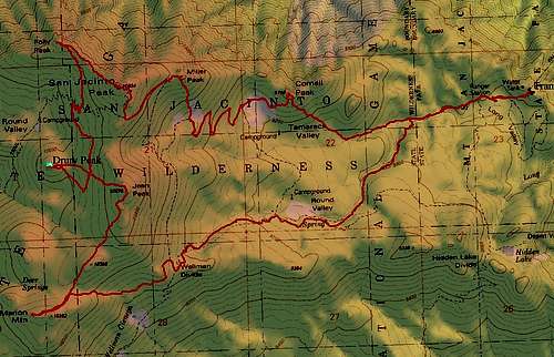
From Folly, we skirted below San Jacinto Peak’s northwest ridge on its west side dropping towards Drury Peak. Drury is about ¾’s of a mile directly south of Folly. We intersected a trail and continued south cross-country. At this point Travis’s GPS gave us its sole failing. If you look at the GPS track of our loop below, you will note a weird triangle pattern near Drury Peak. That represents going off route and our correction. We had followed the GPS track to a point equidistant between Drury and Jean, whereas we should have been much further to the west. We discussed whether we should do Jean Peak first because its summit looked so close. But we opted to cut northwest and continue to Drury.
Drury Peak is an unimposing prominence. In fact, someone in the peak register had dubbed it “Dreary” Peak. Nevertheless, it is a ten-thousand footer and the views from Drury’s summit are actually much better than that of its taller neighbor to the southeast, Jean Peak.
![Fresh Print right below Drury Peak (10,160+)]() Recent visitor below Drury's summit
Recent visitor below Drury's summit![Register Can on Drury Pk (10,160+)]() Drury's summit register and Jean Pk in back
Drury's summit register and Jean Pk in back
From Drury, 10,670 foot Jean Peak is visible most of the way. We took a route directly southeast to Jean’s summit. The configuration of trees and brush on Jean greatly restricts the views from its summit. After a brief pause here, we headed to our last stop, Marion Mountain. This peak is 1 mile directly south of Drury and southwest from Jean (I took out my compass and got a bearing to back up the GPS). We did a straight cross-country shot to Marion skirting just to the west of an unnamed bump shown on the San Jacinto 7.5 minute topo as elevation 10,388’.
Red Finger Tips and a Little Adrenaline on Marion
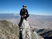
Marion turned out to be as thrilling as Cornell in terms of nice 3d and 4th class climbing to the summit block. Travis and I did different routes from the base of the summit block to the top. Travis found a 4th class section around the summit block and I managed a 4th/low 5th class section that was more direct than Travis’s route. By now, around 2:30 p.m., the winds were at their maximum velocity and chilliness. The temperature was somewhere between 20-25º F. The hose mouth on Travis’s hydration bladder had been freezing up all day and it froze here once again.
![Top of Chimney on Marion Mtn.]() Moving up Marion's summit block
Moving up Marion's summit block
Travis got to the top of the summit block and decided to turn around right away and find shelter from the freezing wind below the summit. However, once I got to the top and discovered that the views were the best to be had on a day where all the peaks except one offered great views, I decided to stay a bit. I signed the peak register for both of us and entered all the peaks we’d done today. Next, I took out my camera to snap away at the views. Then I looked at my topo map to try to get an orientation on our return route to the tram. Finally, Travis yelled up to me asking what I was doing all this time and reminding me that it was nearly 3 p.m. and we wanted to get back before dark.
![View South from Marion Mtn. (10,320 )]() View south from Marion
View south from Marion
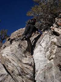
I started back down, but now felt extremely uncomfortable about downcliming the chimney I had come up. I yelled down for Travis to show me his route. As I got into position to descend, jolts of pain shot through my fingertips. I looked at them and they were bright red. I hadn’t donned my fleece gloves on the summit what with signing the register, taking pictures and looking at my topo, and this was the result. Rather than putting on my gloves to warm up my fingertips, I took a shortcut and thrust my hands down my pants. When my hands were warm enough to function, I started down Travis’s route.
Once again, I saw the advantages of Travis’s longer legs. Footholds he had apparently reached with his legs were a little too far down for me. The route was very exposed and the wind kept threatening to interrupt my balance. I groped for handholds and found some good nubs on the left and a nice vertical crack on my right. However, I got to a spot where the next foothold was a small ledge about 18 inches beyond my reach. Try as I might, I couldn’t see alternate footholds. I certainly couldn’t drop to the tiny ledge because my momentum would have taken me right over. I eased my right hand down the crack it was wedged in and found another hold for my left hand further down.
The problem was that the rock at my waist level was overhanging so that I could not see anything below me except for the ledge beyond my reach. I hung on two points from my handholds and started scraping my feet up and down the rock below the overhang trying to find a placement. Just as my mouth was getting very dry (just a little scared don’t you know), my right toe pressed onto a nub that felt secure and then my left foot found a large hold that signaled I could now reach the ledge below. That little struggle filled my quota of excitement for the day although I never mentioned anything to Travis about it.
Full Moon over the Desert
![Wellman Divide (9,700 )]() Sign at Wellman's Divide:Choices, Choices
Sign at Wellman's Divide:Choices, Choices
At 3 p.m. sharp we left Marion and headed east through the brush to intercept Wellman Divide. That was the last of the cross-country hiking. At Wellman Divide, we picked up the trail all the way back to the tram. We just missed the 4:30 tram. We got the 5 o’clock car and were accompanied down the canyon by a huge full moon hovering over the desert floor. Our outing had been 10-11 miles with about 4,000 feet of gain. According to my watch, the 7 peak loop took us 7 hours, 55 minutes.
Our mind-set about the great day was rudely interrupted when we hit Interstate 10. The traffic provided us with a 3-hour drive home, double the time coming in. Oh, well, a minor nuisance really. It couldn’t detract from a most satisfying day we both agreed.
![Route San Jacinto 7 Peaks]() Travis's GPS Track of 7 Peak Loop Hike
Travis's GPS Track of 7 Peak Loop Hike


Comments
Post a Comment