
|
|
Mountain/Rock |
|---|---|
|
|
46.04178°N / 8.03375°E |
|
|
Hiking, Mountaineering |
|
|
Summer |
|
|
10492 ft / 3198 m |
|
|
Overview
Punta di Saas, or Laterhorn, is the second summit from South of the range named 'Cresta di Saas', on the border line between Piedmont(Italy) and Wallis(Switzerland).This group of mountains, located in the East of the Pennine Alps range, divides The Italian Valley of Antrona from the one of Saas in Switzerland.
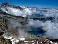
The main ridge of Cresta di Saas runs from South toward North with a steep East flank hanging over the rocky cirque of Camposecco lake in the territory of Antrona.
Tormented by cliffs and narrow couloirs this side of the range has only one easy route, the one of Camposecco pass, that is also the most frequented route to Cima di Saas from Italy.
The West flank descends instead more gently in the territory of Switzerland, in the long valley of Furggbach river, where these summits are often visited during winter by ski-mountaineers.
Latelhorn has four faces: the East flank, facing the village of Antrona Piana and carved by a large snowy colouir, the NE flank, once covered by Camposecco glacier but now almost completely snowless during summer, the small West flank, facing the Mischabel group over the rocky high lands of Furggbach, and the South wall, hanging very steep over the impound of Cingino lake.
This is a fascinating mountain for those who love solitary peaks but doesn't offer hard climbing routes, only scrambling and classical mountaineering in a savage environment.
 Punta Di Saas from Jazzihorn, W
Getting There
From Italy.Antrona valley is easily reachable from Milan (and Malpensa airport) in less than two hours following the highway Milano-GravellonaToce and then the SS33 toward Simplon pass.
Arrived in Villadossola an easy mountain road (SP67) leads to Antronapiana(1020m), the highest village of the valley.
From Antrona Piana a private paved road rises up to the barrage of Campliccioli lake(1300m) at the feet of the mountain.
This last road is usually open for everybody.
From Wallis, Switzerland.
From Brig to Saas Grund and then to Saas Almagell(1672m), the trailhead for approaching the West side of the Mountain across the long valley of Furggbach river.
Simplon pass is the most quick route for moving from the italian side to the swiss one of this range, both by car and by train.
Antrona valley has no railway or bus service so you can avoid the use of car to get to Saas Almagell but not to get to Campliccioli lake.
Huts
 | Bivacco di Camposecco(2300m): near the barrage of Camposecco lake, on the Italian side of the mountain at the basis of the NE face, reachable from Campliccioli lake in less than three hours by a well signed path. |
Cresta biwak(3000m); at the basis of the West face, in the territory of Switzerland, near Saas pass(often called Antrona pass in switzerland) that is easy reachable both from Saas Almagell across the long Furggbach Valley and from Campliccioli lake with a very long trail that gains more than 1700 meters of elevation and covers a long distance in Troncone Valley.
Routes
From West. Cingino lake - Antrona pass route. Expert hikers.From the parking near Campliccioli lake (1300m), cross the dam and reach the North shore of the lake, from here two trails start leading respectively to Camposecco and Cingino lake.
The most direct route to Antrona pass is the one from Cingino lake. This trail crosses all the long troncone till the beautiful cirque of Alpe Lombraoro, then climbs the steep slopes at north to reach the impound of Cingino where the pass is visible at North between Latelhorn and Jazzihorn.
The trail leads to the pass without difficulties crossing under the cliffs of Cingino peaks (no risk of rock falls).
From the pass you have to scramble along the ridge that descend from the summit of Latelhorn remaining on the side of Switzerland (NE), following the cairns (signs made by small pile of rocks) till Cresta Biwak.
From the Biwak climb to the pass on the left of the Summit (Camposecco pass) and then get on the top by the short and easy N ridge.
This trail is very long, it gains almost 2000 meters of elevation and covers more than ten kilometers.
An alternative to break the climb in two days is to reach Camposecco lake(2300m) from Campliccioli, there is a well signed trail that takes less than three hours to the lake.
Near the dam of Camposecco you find a small hut where you can pass the night freely, the hut belongs to the section of the Italian Alpine club of Villadossola.
The following morning you can get to Cingino lake without loosing altitude by the service Tunnel that connects the two impounds, it’s an hour of walking in plane. Take a light with you because the one in the tunnel has an automatic switch off by a timer.
 |  |  |  |
NE face. Camposecco route. Easy mountaineering (I and II of UIAA scale).
From Camposecco there are some cairns at the beginning of the route that guides you along the right trail.
Gaining elevation it becomes more difficult to see the cairns, I think that avalanches in spring usually erase these little pile of rocks.
If you have some doubt on the right direction to follow I suggest to scramble near the Ridge on the left(East), but not on the edge where is exposed and more difficult.
Staying in the proximity of the East ridge makes also easier to find the final couloir that permits to climb the summit ridge and get to Camposecco pass.
Finding this couloir is the most problematic part of the route, It’s usual in fact to find low clouds on this side of the mountain and the couloir could be hided by them.
The couloir is steep and the rocks are friable so be careful if you climb in group.
Once you reached Camposecco pass, the short N ridge leads you quickly to the summit.
If you ascend by this route it’s very pleasant to descend then by the more easy west face, crossing the mountain and enjoying other great views.
 |  |  |  |
 | Saas ridge (II and III UIAA scale). This is the route that from Cima di Saas ascend to Pizzo Bottarello (Sonninghorn 3487m) crossing the entire Saas range, the chain of summits that divides Antrona valley from the one of Saas Fee. Relatively Easy route, entirely on rocks, in a solitary environment with fantastic views. Descending from Bottarello is long and not easy, both from the Italian or Swiss side. If you descend on the italian side you will find your self in Loranco valley, but you can get back to the Camposecco impound by "coronette di Camposecco" pass. The rock is not always firm, but, for the fact the route follows the edge of the ridge, the risk of falling rock is very low |
 3D map by Google Earth
External Links
www.valleantrona.comInfo about the accomodations, trails and huts.
Saas Almagell
Info about the accomodations, trails and huts.
Weather in Italy and over the Alps