
-
 31281 Hits
-
 94.63% Score
-
 48 Votes
|
|
Area/Range |
|---|---|
|
|
49.35376°N / 87.51709°E |
|
|
14790 ft / 4508 m |
|
|
Overview
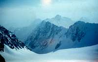
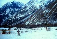
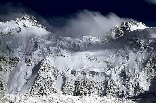 Belukha North Face
 Timberline winter camp in Katun'skie Belki
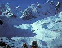
 Skiing Mensu Glacier, Belukha Massif
Altay Mountains, straddling the border area between Russia, Mongolia, China, and Kazakhstan, are a vast complex of rugged Alpine ranges, rounded iceshield domes, and endless taiga and grassland foothills and high plateaus.
The name Altay means Golden in Turkic and Mongolic languages, and this area was always referred to as Golden Mountains in the Chinese Chronicles.
The high point of Siberia, Belukha ( 4507 m ), and the high point of Mongolia, Nayramdal Peak (a.k.a. Nayramadlin Orgil or Huyten Orgil) ( 4374 m ), are located here. Numerous other peaks rise above 4000 m mark, and over a thousand extant icefields include vast shield and valey glaciers.
The valleys of Altay were a craddle of vast outmigrations of ethnic and linguistic groups. DNA studies of Altay tribesmen linked them to the Eurasian Ancestors of Amerindians. Samodian and Ket language groups are thought to have spread North from here. V century BC mounds of Pazyryk in Eastern Altay hold clues to the origin of the famed Scythians. The remnants of the earliest Turkic peoples, known to the Chinese chroniclers as the Dingling, still live here.
A 16,000 square kilometers swath of the area is designated a UNESCO World Heritage Site under the name of "Golden Mountains of Altai", and a network of National Preserves is established for protecting rare animals such as snow leopard and central asian mountain sheep.
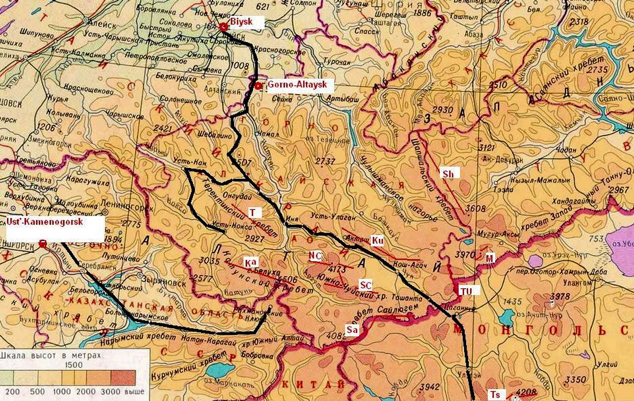
Sub-ranges of Altay
 |
|
Main Mountain Ranges (red lines) : Ka - Katun'skie Belki Ku - Kuraysky M - Mongun-Tayga NC - North Chuyskie Belki SC - South Chuyskie Belki Sa - Saylyughem Sh - Shapshal'sky T - Terektinsky TU - Turgen-Ula Ts - Tsast Main Roads into Altay (black lines): - Chuysky Trakt from Biysk into Mongolia, with its branch, Ust'-Koksinsky Trakt - Bukhtarma Valley Road from Ust'-Kamenogorsk to Rakhmanovskie Klyuchi |
Northern Ranges
The most extensive alpine glaciation in Altay is found in its three Northern Ranges, where all mouuntain groups are appropriately called Belki (Whites in Russian).
Katun'skie Belki
 East Summit of Belukha
 Mul'ta Lakes Group
Katun'skie Belki are named after famed Katun' River, which semi-circles these mountains from its source in the Southern glaciers of Belukha (4507 m), flowing South, then West, then North, and finally East. Timberline is near 2,000 m. The woods consist of lush South Siberian Taiga with abundant stands of Siberian Cedar, the source of all-familiar pine nuts.
The massif of Belukha, with its astounding North Face known as the Akkem Wall, is the highest in Altay and in the entire Siberia. Valley glaciers spread North, East, and South. The most popular access route leads to Akkem Lake from Tyungur, to the North-West on the left bank of Katun' River. Alternative access from the Kazakhstani (South) side is from Yazevoye Lake.
West of Belukha the crest of Katun'skie Belki drops sharply to below 3,000 m. However this region recieves the heaviest precipitation of all Altay, and the mountains of Multa Lakes Group carry very extensive modern glaciation. The taiga of lower valleys is used as a range for for semi-domesticated maral elk, prized for the medicinal properties of their young antlers.
Chuyskie Belki
 Krasavitsa Peak and Zelinsky Glacier, North Chuyskie Belki
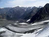 Maashey Glacier, view from Nadezhda Pass
East of Belukha, separated from it by the deep cut of Argut Gorge, are Chuyskie Belki, named after Chuya Valley at their North-Eastern base.
Chuyskie Belki consist of two parallel ranges, connected by a high ridge of Karaghem Pass. The climate is considerably more arid here, and much of the taiga is dominated by Siberian larch, although the cedars are common too. Both valley and shield glaciers abound. Lower timberline is at higher elevations, especially in the South-East where the forests nearly disappear from the mountain slopes, with the alpine tundra directly transitioning into the foothill steppe.
The highest point of North Chuyskie Belki is Maashey-Bashi (4177 m), North-East of the junction with the Karaghem Connector Range. Numerous rugged summits exceed, or approach, the 4000 m mark both East and West of Maashey. Access to this area is typically from the North-East, from the villages of Chibit and Aktash in Chuya Valley
 Abyl-Oyuk Glacier, North Chuyskie Belki
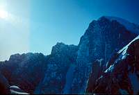 Rugged crest of North Chuyskie near Krasavitsa Peak
Karaghem Connector is a relatively short but rugged range joining together North and South Chuyskie Belki. A deep hollow of Karaghem Pass used to be the route of trading camel caravans between Kosh-Agach and Argut Valley, but it has long since fallen into disrepair.
Iiktu Peak (3936 m) a.k.a. Irbis-Tu is the highest point of South Chuyskie Belki, at its junction with Karaghem Connector Range. The area is typically accessed from the East, from Kosh-Agach in Chuya Steppe Valley.
Grassland valleys at the base of Chuyskie Belki are used as a winter range for sheep, yaks, and camels by the Telengit pastoralists, since there is hardly any snow in these valleys in winter. In fact in South Chuyskie Belki, the Eastern foothills don't have any appreciable winter snowcover all the way to the glacier zone. The taiga of the Northern slopes is used for sable-trapping.
Southern Ranges
Tavan-Bogdo-Ula ( Mongolian for Five Sacred Summits, 4374 m), and Saylyughem Range extending it to the East, mark the border between Russia and Mongolia. The 4000'ers are rounded ice domes towering alpine high steppe plateaus. The access here is mostly from the Russian side, from Kosh-Agach. The highest point of Mongolia, in Tavan-Bogdo-Ula group, is at the junction of China, Mongolia, and Russia, and it has been renamed Nayramdal (i.e. Friendship) Peak back in the Communist times to underscore the links between the three nations.
 Kuraysky Range , view from Oroy Divide
Further South into Mongolia, there are more 4,000er ice domes such as Tsast (4208 m) and Munkh-Khairkhan (4362 m), typically accessed from from Bayan-Ulghiy (80 km from the Russian border along the historical Chuysky Trakt highway).
Mongolian Altay ranges continue further South-East for hundreds of miles, all the way into Gobi-Altay aimak (district) of Mongolia, but these desert mountains are neither glaciated nor very rugged.
Eastern Ranges (Chikhachov Mountains)
Along the remote Eastern boundary of Russia's Altay Region, collectively known as Chikhachov Mountains, two glaciated mountain groups stand out.
In the South part of Chikhachov Mountains, which marks Russian-Mongolian border here, towers arid and virtually unvisited Turgen-Ula Range ( Turgen-Ekhini-Ula, 4029 m). Further North-East, along the Altay-Tuva regional border, is Mongun-Tayga Range ( Mongun-Menghi-Khayirakan, the highest point of Tuva) (3976 m)
Climate
 Naled Ice, Mul'ta Lakes Group
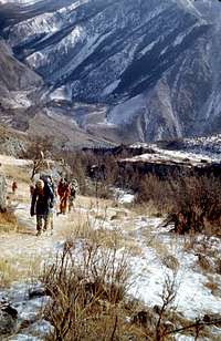 Snow-less Yedyghem Valley is the Telengits' winter yak pasture
Altay has pronounced continental climate with dramatic temperature variations and arid rain shadow areas.
While the higher elevations on the West flank of the mountains, and local lake effect areas near Teletskoye Lake, recieve as much as 2000 mm of precipitation a year, the Eastern Valleys typically recieve no more than 200 mm a year, and rain-shadow intermountain depressions of Chuya Steppe and Ubsu-Nur Lake as little as 100 mm.
Most of precipitation falls in spring and fall, with mid-winter dominated by an exceedingly stable Siberian High pressure area, which keeps the snowclouds away. As the result, the intermountain valleys loose snowcover to evaporation as early as in January-February. The temperatures remain extremely low however, with January averages in Chuya Steppe and Ubsu-Nur Depression at about -30 degrees C, and with cold spells up to -50 not too uncommon. So rivers and waterfalls remain frozen even in the absence of snow, and naled ice (aufeiss) is relatively common too.
The summer temperatures in the foothills are temperate, averaging approximately 20 degrees C.
Ethnic Groups and Languages
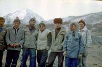 With Telenget herders in Argut Gorge
 The ice of Argut is Telengits' winter sheep trail
Altay is the ancestral land of Turkic peoples, who radiated out of its mountain valleys in several ways of expansion starting from the V century AD, most famously during Genghis-Khan era. High plateau tribes of Teleut and Telengit are the remnants of the era of Turkic ascendancy.
Telengit language is an archaic and Mongol-influenced Turkic, and their dominance over the steppe intermountain valleys of Altay dates back to the upheavals of early Tang dynasty era, and to the obliteration of Eastern (Blue Turk) Qaghanat by the ascending Emperor Taizong in A.D. 630.
After the campaign of 630, some ex-Qaghanat tribes of Tele (Chin. Dingling) moved to Altay and subjugated Qarlug of Irtysh Basin and Kyrgyz of Enisey Basin. In the following decades, expeditionary forces of the Tang destroyed Tele's regional dominance, but they held on to their Altay heartland ever since.
 Camel Winter Pasture at Karaghem
 Kazakhstani (Southern) Altay
Three centuries after Genghis, Western Mongolia and much of today's Kazakhstan broke away from the dominace of the more numerous Khalkha Mongols under the egidae of Oirat tribal Union. The Oirats expansion brought the Mongol tribes as far away as to Eastern European steppes before they succumbed to Manchu and Russian empires in mid-XVIII century. The remnants of Oirats are spread throughout Mongol and Chinese Altay, principally the Turguud (Torguut), Zakhchin, and Khoshut tribes to the South and Derbet, Oliot, Uzemchin, and Miangat to the East.
Kazakhs, who like most Turkic people trace their distant origins to Altay, moved into the grasslands South and West of the Range after Genghis scattered their Kipchak anestors from their Great Steppe homeland. Today Kazakhs live in Kazakhstan proper as well as in China and Mongolia. Large numbers of them moved East to avoid Soviet collectivization of agriculture in 1930s, but later, especially after Kazakh independence, the direction of migration reversed.
Russians live predominantely to the North, both in Russia and in Kazakhstan. Old Believer Russians started emigrating here in the XVII century to avoid religious persecution in this mystical land of White Waters. By XVIII century, mining attracted a new wave of Russian migration, with the fort of Semipalatinsk (Semey) established in 1718. Soon the area was annexed into Russian Empire.
A number of other smaller Turkic groups are autochtonous to the mountain valleys of Altay, including Altay-Kizhi of the Northern Slopes (which were formerly known as Oirots due to their subjugation by the Oirats of Western Mongolia), and Uriankhai of Mongolian Altay (the Mongolian word Uriankhai originally applied to many Khangai woodland tribes, and especially to the Tuva, but now it is limited to lingustically Mongolized descendants of Tuva). To the East, in Tuva proper as well as across the border in Mongolia, live Tuva people, decendants of the historical Dingling as well as now-extinct Southern Samoyeds. In the Ubsu-Nur Valley on Tuva-Mongol border, East of the crest of Turgen-Ula, live Khotons and Bayats.
Sacred Mountains
 Katun' Valley in winter
Shamanist Lady Katun'
The name of Katun' River, the main waterway of Altay, is ancient Turkic for "Lady" - the river herself is the sacred Woman Spirit. And another ancient Turkic spirit-worship word Kam, which means shaman, is still commmon in the place names around Altay mountains.
Buddhist Tavan-Bogdo-Ula, the Gate of Shambhala
Tavan-Bogda-Ula, or Five Sacred Summits, is a chain of giant ice domes at the border of Mongolia and Russia. Their holy nature is related to the Buddhist myth of the Hidden Kingdom of Shambhala, which rests high in the mountains, and which can only be seen by those pure of heart. Specifically in Mongolia, an epithet "Northern" frequently accompanies the word "Shambhala" in the hymns, to reinforce the idea that it is not somewhere in Tibet, but in fact in the Sacred Summits of Altay.
 Skazka Peak, Fairy-Tale in Russian, is one of Enchanted Mountains of Chuyskie Belki, with the names like Dream and Fairy-Maiden
Orthodox Old Order Quest for Belovod'ye
Mythical Belovod'ye, or the Land of White Water, is very much a Russian Schismatic reflection of the Buddhist ideal of Shambhala, and it was sought in the same places, from Altay to Himalayas.
The roots of this myth go back to the violent schism of Russian Orthodox Church of XVII century. The Old Believers were persecuted and their prisoner labor has been widely used in Czarist Russia since late XVII century. An imperial decree of 1737 ordered their use at the Factories and Mines of the Treasury in Siberia. In 1762 another decree offered Old Order refugees in Poland assistance to resettle in Altay. Although escapes from the mines were severely punished, by early XIX century the secret villages of Old Believers abounded in the taiga of Altay.
About the same time, Arkady Belovodsky, an impostor "envoy" from the Hidden Kingdom of Bolovod'ye, started preaching among the European Old Believers about his mystical, powerful country in the East, somewhere beyond China. The White Waters Land of Arkady's sermons retained pre-schism Antioch Orthodoxy, with seven hundred churches on a huge island. It had a distinctly Shambhala-like quality in that only the truly enlightened people could reach the White Waters.
Also about the same time, a splinter Old Order group formed the Community of Truly Orthodox Travelers, better known simply as the Runners. They moved from a safe house to a safe house using hand-written route charts.
 Pyramid of Roerich Peak
By 1830s, these three developments crystallized together into the Old Believer quest for Altay Belovod'ye. Believers were trickling from all over Russia, guided by their route-scripts. Some sought the Hidden Land up in the highlands, where all the peaks where called, indeed, Whites. Other continued up Bukhtarma Valley and crossed the border with China. The Old Believers' searches for White Water Land did not abate until 1910s. Today's folk wisdom in Russia pretty much equates White Water Land with the White Peaks of Altay.
Agni-Yoga and the Origin of Shangri-La
Nicholas Roerich (a.k.a. Nikolay Rerikh), the founder of Agni-Yoga mysticism and the popularizer of Shambhala myths, is better known to the Western world through the story of Shangri-La they inspired.
The Shambhala, "somewhere North and West of the Himalayas" is alternately placed in the mountains of Altay or Kunlung. Roerich's followers seek it in the shadow of Belukha, and the valley trails see quite a bit of esoteric pilgrim traffic.
Getting There, Red Tape, etc.
 Chibit Bridge at Chuysky Trakt is the gateway to North Chuyskie Range
The area's principal airports are in Barnaul, Russia, and Semipalatinsk, Kazakhstan.
The main ground transportion artery of Russian and Mongolian Altay is the Chuysky Trakt highway (Russian route M52), commissioned by the merchants of Russian city of Biysk back in 101-1903. A principal branch road splits from Tuekta to Ust'-Koksa and then towards Mul'ta and Tyngur, the staging points for Western and Eatern Katun'skie Belki, resp. There is limited bus service on both roads from Gorno-Altaysk, the capital of Highland Altay. Private mini-buses and trucks may be hired both at Gorno-Altaysk bus terminal and, more conveniently, at Biysk RR terminal plaza.
There are border area restrictions in place near the borders between Russia, Kazakhstan, China, and Mongolia, and additional visa / customs hurdles for those crossing the borders.
Help on up-to-date information about transportation links, permits, visas, and customs restriction is appreciated. Actually there is a lot more missing in this page, especially maps and images, and all kinds of help / co-ownership of the page are welcome!