
-
 4311 Hits
-
 76.66% Score
-
 7 Votes
|
|
Route |
|---|---|
|
|
42.16190°N / 123.7831°W |
|
|
Hiking |
|
|
Spring, Summer, Fall |
|
|
A long day |
|
|
some Class 2 |
|
|
Getting There

Zero your odometer here and start heading west on this paved road. At 1.0 the pavement narrows, at 2.7 cross the famous green steel bridge over the Illinois River. This green bridge has been the sight of many logging protests and some violence. At 3.1 the pavement ends at the Josephine Campground. At 3.7 stay right and then just stay on the good main road for several miles as it climbs up over 4,000 ft. At 14.3 go left and ignore several spur roads that branch off the main road. At 15.0 miles arrive at the Babyfoot Lake trailhead on the right. There is a nice new vault toilet at the trailhead.
Route Description

Take the well marked trail south from the trailhead for about .3 of a mile where you come to a signed fork in the trail. Take the left fork marked as the Babyfoot Lake Rim Trail 1126. The right hand trail goes down to Babyfoot Lake and you lose about 400 ft of elevation.
Stay on the trail as it passes above Babyfoot Lake that you can see about 700 ft below you to the north. The trail climbs over a little ridge and reaches an elevation of about 4,780ft. before it drops down to an old road bed. This is about 1.8 miles from the trailhead. At the roadbed, make sure you look around so that you recognize where the trail is. There is a small sign marking the spot, but you have to be alert to see it nailed to the tree. Where the trail meets the roadbed, turn left or south and follow the road for about another 1.4 miles towards Canyon Mountain.
[img:363993:alignright:small:]
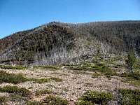
At the saddle before Canyon Mountain there is another sign and a fork in the road. This one indicates the Bailey Cabin Trail 1131 is to the right. Do not take this trail. Instead, continue straight ahead along the ridge towards Canyon Mountain. The trail is a little overgrown in spots, but it is a good trail.
Stay on the trail as it passes Canyon Mountain (a side trip to its summit is worth the effort). The trail descends towards Cold Spring and loses 400ft in elevation. Before Cold Spring there is a fork in the trail, pay attention, otherwise you will end up down at Emily Cabin on the Chetco River. Take a left at the fork and follow the trail to Cold Spring. There are several large old growth trees that have blown down across the trail at Cold Spring. Make your way around the trees and to the small level clearing on the other side where the spring is. There is a campsite nearby. The trail is hard to follow here, but continue on past the campsite up the hill and you should find the trail as it starts to climb back up to the ridgeline.
[img:363996:alignright:small:]
If you can’t find the trail, just hike up the hill to the ridge where you will find the trail. Once up to the ridge, you will finally catch a view of Josephine Mountain off to your front left. Continue on the Kalmiopsis Rim Trail to a rise about a mile beyond Cold Spring that has elevation 4441 on the topo. This is where you leave the trail and head eastward cross country towards Josephine Mountain. There is no trail here, so you have to pick the best way down to a saddle at elevation of 3,775 ft and then back up the western ridge of Josephine Mountain.
There is no easy way down the ridge and it is brushy in spots. The left side of the ridge looks more clear but it is steep. The right side is not as steep, but it is more brushy. There are also some rocky areas that are steep also. Once you get down to the saddle, the brush has been burned off and it is easier hiking. Hiking back up to the summit of Josephine Mountain you have options. The slope is quite rocky and steep and you have to pick your route up to the summit. I found an old trail off to the right of the nose of the ridge heading up. It has been abandoned and is overgrown, but it may be easier than boulder hopping up the ridge. Don’t spend a lot of time looking for this old trail, just head up.
Once you get up to the ridgeline, you will see the highpoint at the head of the Rocky Bar Gulch Canyon. Follow the ridge around to the highpoint. The bare highpoint has a couple rock piles that are about 10 ft high. They are about the same height and either one could be the highpoint.