
|
|
Mountain/Rock |
|---|---|
|
|
45.27745°N / 7.13566°E |
|
|
Hiking |
|
|
Summer |
|
|
10876 ft / 3315 m |
|
|
Overview
Punta Maria seen from refuge Gastaldi seems like a rocky pyramid on the left side of Col d’Arnas, it is well know and frequented for the easy access. The name was defined by the first ascents climbers in honour of miss Maria Castellano, the pretty keeper of refuge Gastaldi at the beginning of 1900.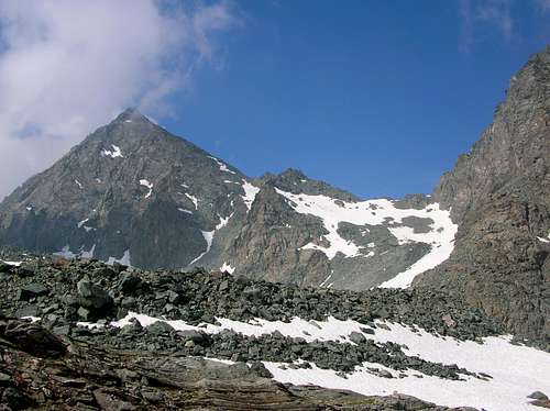
Punta Maria
Getting There
- Italy: from Turin motorway A55 exit Venaria Reale follow indications for Lanzo Torinese and go on through Germagnano and Ceres, here you enter in Val d'Ala, continue passing Ala di Stura and Balme and reach Pian della Mussa (1830 m.) where the road ends (78 km from Turin). From here in 2.30 h on a good path you can reach the Rifugio Gastaldi.- France: from Modane motorway A43 exit Le Freney follow indications for Val Cenis, Bessans, Bonneval sur Arc and Col de l'Iseran. Just after Bessans turn right towards Les Vicendieres and Averole. Reach the parking just before Les Vicendieres (1880 m., 45 km from Modane), only allowed person could go on with the car. From here in 1.30 h on the road or 1.10 h on a good path you can reach the Refuge d'Avérole.
Red Tape
There are no fees or permits.Pay parking at Pian della Mussa, at the start of the route to Rifugio Gastaldi, there are no limitations for climbing and hiking. No problem for one night free camping, take care of nature as usual!
Park at Les Vicendières, at the start of the route to Refuge d'Avérole, it is free and there are no limitations for climbing and hiking. Free camping is forbidden, the whole region is part of the Parc National de la Vanoise you should take care of nature as usual limitations of natural parks.
Normal route
Here we describe the normal route, this route is used both from Italian and French side.ITALY - From Rifugio Gastaldi (2659 m) descent on a good path to the Crot del Ciausiné, reached a terrace turn right and proceed on rocks and grass ledges till the slope (snow in spring and summer start) who finish with the Colle d’Arnas (1.15 h).

Col d Arnas
FRANCE - From Refuge d’Avérole (2210 m) proceed to SE on the path to the torrent, go on following the right bank (hydrographic, left bank mounting) and reach the Arnès Glacier. The glacier is easier, without big crevasse and finish a few meters below the Colle d’Arnas (3 h), for Punia Maria summit (normal route) it isn’t necessary to reach it.
Punta Maria
DESCENT: Descend on the same route, pay attention on the glacier some big crevasse are present.
Other route: NO ridge
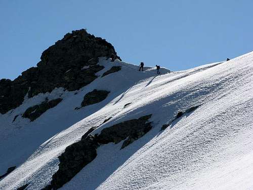
Here we describe the NO ridge route, it is a beautiful and interesting route on the ridge from Colle d’Arnas, at the beginning on debris and after on a sequence of small rocky steps on an exposed ridge, this route is used both from Italian and French side.From Colle d’Arnas (3010 m) see normal route to reach the Colle d’Arnas, proceed directly on the ridge on debris and reach the first rocky step, overcome it directly and traverse a little bit on the Italian side, from here climb a chimney to return on the ridge and proceed directly on the exposed but not difficult ridge where there is the more safety route. (About 1.45 h from Colle d’Arnas, difficulty PD, II depending on the conditions).
DESCENT: Descend on the normal route, pay attention on the glacier some big crevasse are present, if you do not have crampons and ice-axe descend on the same route NO ridge be careful for the exposition of some pass.

Punta Maria - NO Ridge
When To Climb
The best time is from June or July (depending of snow quantity and conditions) to September.For the normal route we suggest before the end of July.
First Ascents
NO ridge: L. Barale, M Borgarelli con P. and P. Castagneri – Aug 14, 1904NE wall: E Calcagno, C. and E. Chioatero, A. Paracchi – Sept 5, 1920
E wall, direct: A. Sancito, I. Negro – Aug 13, 1943
O wall: L. and G. Bonis
Accomodations
You can find accommodations in all villages of Valli di Lanzo and Vallée de l'Arc.You can use Rifugio Gastaldi as base for the ascents to: Uja di Ciamarella (3676 m), Albaron di Savoia (3627 m), Bessanese (3604 m), Piccola Ciamarella (3540 m), Punta Chalanson (3466 m), Punta Maria (3302 m.). Refuge is open from 01/04 to 21/05 and from 1/06 to 17/09
Contacts: Rifugio Gastaldi phone +39 0123 565008 www.rifugiogastaldi.it
You can use Refuge d'Avérole as base for the ascents to: Albaron di Savoia (3627 m), Bessanese (3604 m), Punta d'Arnas (3560 m), Punta Maria (3302 m.).
Contacts: Refuge d'Avérole phone +33 04 79 05 96 70, Club Alpin Français de Lyon phone +33 04 78 42 09 17
Books and Maps
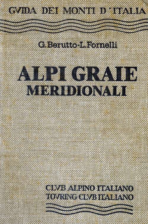
-BOOKS- G. Berruto, L. Fornelli " Guida dei Monti d'Italia - Alpi Graie Meridionali" Club Alpino Italiano/Touring Club Italiano (1980). (Italian)
google books - Guida dei Monti d'Italia - Alpi Graie Meridionali
MAPS
- IGC- Istituto Geografico Centrale
N° 103, 1:25.000
Rocciamelone Uja Di Ciamarella Le Levanne
- ASF- Alpi senza frontiere / Alps without frontiers (IGN Institute Geographique National)
N° 13, 1:25.000
Mont-Cenis Ciamarella
- IGC- Istituto Geografico Centrale
N° 2, 1:50.000
Valli di Lanzo e Moncenisio
www.nimbus.it
www.regione.piemonte.it official site of the Regione Piemonte
www.meteofrance.fr
Mountain Rescue phone n°: Italy 118 , France 04 79 05 11 88
Avalanche Bulletin: www.aineva.it
Union of Mountain Guides (Piemonte-Valle d'Aosta) phone n°: +39 011 5171628
- IGC- Istituto Geografico Centrale
N° 103, 1:25.000
Rocciamelone Uja Di Ciamarella Le Levanne
- ASF- Alpi senza frontiere / Alps without frontiers (IGN Institute Geographique National)
N° 13, 1:25.000
Mont-Cenis Ciamarella
- IGC- Istituto Geografico Centrale
N° 2, 1:50.000
Valli di Lanzo e Moncenisio
Mountain Conditions
You can get whether forecast at this site:www.nimbus.it
www.regione.piemonte.it official site of the Regione Piemonte
www.meteofrance.fr
Miscellaneous Info
Useful:Mountain Rescue phone n°: Italy 118 , France 04 79 05 11 88
Avalanche Bulletin: www.aineva.it
Union of Mountain Guides (Piemonte-Valle d'Aosta) phone n°: +39 011 5171628