
|
|
Canyon |
|---|---|
|
|
37.41735°N / 111.00483°W |
|
|
Hiking |
|
|
Spring, Summer, Fall, Winter |
|
|
Overview
One of the more popular canyons in the Escalante River tributary system, Coyote Gulch is an adventure of exploration and wonder. Though located in the remote Glen Canyon National Recreation Area of Southern Utah, Coyote Gulch is worth the time and effort required to visit, and worthy of its famed status. While exploring Coyote Gulch, you will see the landscape much the same way that the Anasazi culture and early Western explorers, soldiers, and settlers did. Characterized by sparkling streams, impossible arches, and daunting vertical walls of Navajo Sandstone, you will be raving about this canyon for years after your trek. Plunge yourself into the heart of geologic time as you contemplate the eons that have preceded your insignificant life span. How will you navigate these emotional floods of humility and adventure as you gaze over the matchless beauty before you?
Features
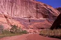
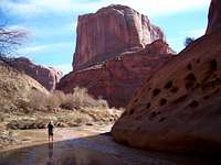
| Jacob Hamblin Arch | ||
|---|---|---|
 |
 |
 |
 |
 |
 |
Three main attractions lure visitors to this beautiful canyon. These are two arches and a natural bridge. Jacob Hamblin Arch (also known as Lobo Arch) is the furthest up the canyon. (See Above) Its dwarfing size is truly amazing. Coyote Natural Bridge is very picturesque. (See Below) The sandy stream banks and shady trees make this a nice place for lunch or a campsite. Cliff Arch (also known as Jug Handle Arch) can also be seen further down stream. Truly it looks like a mug handle jutting out from the canyon wall.
| Coyote Natural Bridge | ||
|---|---|---|
 |
 |
 |
 |
 |
|
As a bonus, Steven’s Arch (also known as Skyline Arch) on the Escalante River can be seen at the confluence of the canyon and also from the rim at the crack-in-the-wall.
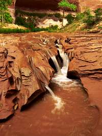
On top of all this, you will see waterfalls and possibly traces of the ancient Anasazi culture, which formerly inhabited this region.
History
There is a variety of human history surrounding Coyote Gulch and the adjacent areas.
--The ancient Anasazi culture has left clues to their inhabitation of the canyons. Petroglyphs and pictographs can be seen in the canyons. Nearby at Boulder, Utah, Anasazi State Park is located with a visitor center and museum.

--Most likely, the first white man to visit this area was due to activities during the Black Hawk War in 1866. The territorial militia under command of Captain James Andrus would have led his cavalry through these parts.
--Hole-in-the-rock road was the result of an immigration expedition where a direct route to the San Juan River was blasted through the canyon walls of Glen Canyon down to the Colorado River. Dance Hall Rock, near the turnoff to Fortymile Ridge Trailhead, was a popular stop along the road for the early immigrants. Follow this Park Service link for more details of this story.
--Uranium mining operations also took place in the area during the 1940s and 1950s.
Getting There & Trailheads
The closest town to Coyote Gulch is Escalante, Utah which is remote in and of itself. Goods and services should be available there. Escalante is located on State Highway 12, which is the same highway that makes a big loop between Bryce Canyon National Park and Capitol Reef National Park. Escalante is about 41 Miles East of the Bryce Canyon turnoff, and about 118 miles East from Cedar City on I-15. The entire route is a scenic byway. Or if you are coming from the East on I-70, you can exit at Sigurd and follow State Scenic Byway 24, which eventually turns into Highway 12. The distance from I-70 is about 130 miles. Either way, you will definitely want a road map to follow.
Just about 5 miles East of the town of Escalante, Highway 12 makes a big U curve from SE to NE. At the bottom of the U, you will be exiting the highway to the South on a large, maintained dirt road. Coming from the East, this road is about 5.5 miles from Boulder. The road is called Glen Canyon Recreation Area Road. It also used to be called Hole-in-the-Rock Road. You should be heading SE on this road. Fortymile Mountain will be on your right as you travel down this road. You will continue down this road between 30 to 35 miles, depending on where you will begin your hike.
CAUTION: The roads to these trailheads may be washed out or have stretches of soft sand. A four-wheel drive vehicle is recommended.
Here's a link for Scenic Highway 12
A Link for Hole-in-the-Rock Road
Lower Coyote Gulch via Fortymile Ridge Trailhead
This is the approach you will want to take if you intend on only exploring the lower portion of Coyote Gulch. This happens to be the longest drive between all the routes. You will drive SE on Glen Canyon Recreation Area Road for 35 miles from Highway 12. You will take a road that turns to the left called Fortymile Ridge Road. This road definitely has deep sand in places. You will follow this road for 7 miles to the trailhead parking lot. There will only be one intersection along the way, where you will stay left.
Hurricane Wash Trailhead
This is probably the easiest entry into Coyote Gulch. This trailhead is about 33 miles from Highway 12. There are no roads to turn off onto. When you are approaching this trailhead you will see a turnout to your left that leads to a livestock corral. Immediately after this turnout, there will be another turnout to your right. Pull off here: this is your destination. You have already parked in the dry Hurricane Wash. Just head downstream (East) from here.
 Hurricane Wash. Submitted by tp
Red Well Trailhead
An alternative to Hurricane Wash, Red Well takes a different dry wash into the Coyote Gulch. The turnoff for Red Well is 30 miles from Highway 12. The turnoff will be to the left. There should be a sign for the turnoff. Take this turnoff for a little over a mile where you will come to a fork. Take the left fork, which will finally end in a turnaround less than a mile later.
When to Go
Best times to go are March to mid-June and September to October. Flash floods are more common in the summer, but can happen at any time. Nights can be cool in the spring. Temperatures can fall below freezing in the winter. During the summer you will be fighting heavy heat and endless deer flies.
Red Tape
Coyote Gulch resides in the Glen Canyon National Recreation Area. Use of the area is free, but please obtain a backcountry permit. These can be obtained at the trailheads of Red Well and Hurricane Wash, or at the Visitor Center in Escalante. Please contact the Visitor Center if you plan on taking organized groups like the Boy Scouts.
Escalante Interagency Visitor Information Center,
PO Box 511
Escalante, UT 84726
435-826-5499
Routes
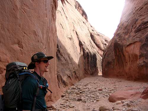
The routes are all very simple; get into the canyon and follow the stream. The course is a very easy hike, but your feet will get wet, so wear appropriate footwear. There are a few exceptions to the ease of travel. They are the waterfalls. You will have to climb up or down (depending on your direction) steep sandstone ledges. I climbed them without ropes, while wearing my 40 pound pack.
Red Well and Hurricane Washes
These trails are very straightforward. Follow the dry streambed until you join up with Coyote Gulch. Your general direction will be to the East.
Hurricane Wash- Remains dry for about four miles. It is about 12.3 miles to the Escalante River.
From the junction with Coyote Gulch to the Escalante River is almost 8 miles.
Red Well-Red Well joins Coyote Gulch at a point that it is also sandy. Red Well to the Escalante is over 13 miles.
Fortymile Ridge Trailhead to Crack-in-the-Wall
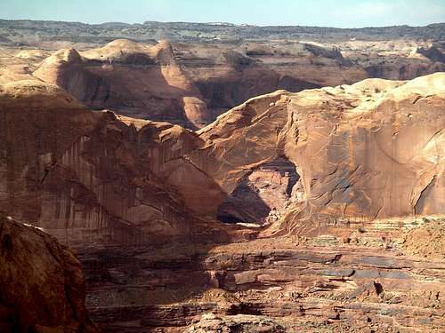
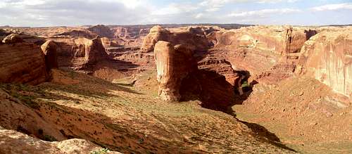
 The Confluence
This route is a little trickier. From the parking lot you need to follow an approximate NE direction. You will be traveling across the desert plain to the rim of the lower canyon. From the parking lot you can see the confluence of Coyote Gulch and the Escalante. (See above.) Get your compass bearing for this landmark before you leave the parking lot. From the trailhead, you will lose a little elevation and then the landmark will no longer be visible. A trail should normally be visible.
Eventually, the trail becomes slickrock and you will have to keep an eye out for a cairn on the rim of the Coyote Gulch that marks the location of the crack-in-the-wall. Crack-in-the-wall is a slice of sandstone that has broken off from the canyon wall and has created a nice pathway from the top of the rim to the giant sand slide below. Crack-in-the-wall is narrow enough that you will have to remove your pack as you slide through. From here, it is a 700-foot descent from the top of the sandslide down to the stream. (See Below.) Stay to the left of the large sandstone formation in the middle of the slide. If you go to the right of the formation, you will find a nice overlook of the Escalante River. Please stay on the trail to help prevent excessive erosion. Once down at the bottom, you can follow Coyote Gulch downstream to the Escalante River. From the trailhead to the Escalante River, the distance is 2 miles. Of course, you can trek upstream through Coyote Gulch, if you desire. Many who go this direction often exit the canyon by ascending some slickrock near Jacob Hamblin Arch. Once out of the canyon, you will travel cross-country back to the parking lot. The author took this course and completed it in two pleasant days.
 Above Crack-in-the-Wall. Confluence is directly below. Steven's Arch across the way. Submitted by SteveMarr
These are the approximate routes:
View Coyote Gulch in a larger map
Camping
This country is pretty remote; any camping you do will be done on your own. Because of the harsh conditions please be considerate of your impact on the plants and soil. There are some shady high-ground locations that can be found in the canyon. You just have to look out for them. I found a nice spot just East of Coyote Natural Bridge on the North bank. There’s also a nice place just downstream from Jacob Hamblin Arch. Here is a link to the Canyons of the Escalante Information and Hiking Guide.
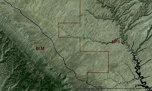 For clarification: the agency border is in orange, Hole-in-the-Rock Road is in black, and Coyote Gulch is located right under the NPS label. Image produced by the page author in ArcGIS using data from the Utah GIS Portal.
Here’s a summary of the information:
-Groups size limit is 12, recommended 8
-Campfires are not allowed in the Glen Canyon NRA and discouraged on BLM lands.
-No pets in the canyon
-Do not collect historical artifacts. Fines may be imposed.
Please review this Park Service guide for more guidelines on minimum impact camping and hiking.
If you’re looking for a campground to stay at overnight before heading into the canyons, there are two back on Highway 12. Escalante State Park is located in the town of Escalante. Calf Creek Recreation Area is located halfway between the towns of Boulder and Escalante. Fees apply.
Utah State Parks Link
Needless to say, this is a harsh desert, so please drink adequate amounts of water.
--National Geographic Trails Illustrated produces a nice map for this area called Canyons of the Escalante Trail Map. Click here for the link.
USGS Maps
7.5 Minute—King Mesa, Big Hollow Wash, Sooner Bench
15 Minute—The Rincon
1:100,000-- It’s not on the Escalante, UT or Navajo Mountain, UT maps. Maybe there is none??
Get your Glen Canyon NRA wildlife checklists here:
-Groups size limit is 12, recommended 8
-Campfires are not allowed in the Glen Canyon NRA and discouraged on BLM lands.
-No pets in the canyon
-Do not collect historical artifacts. Fines may be imposed.
Please review this Park Service guide for more guidelines on minimum impact camping and hiking.
If you’re looking for a campground to stay at overnight before heading into the canyons, there are two back on Highway 12. Escalante State Park is located in the town of Escalante. Calf Creek Recreation Area is located halfway between the towns of Boulder and Escalante. Fees apply.
Utah State Parks Link
Water
There is no water at the trailheads. You will have to rely on natural water sources. Springs can be found inside the canyon. Heading downstream, the first one is found just past Jacob Hamblin Arch. Otherwise, you can treat the water from Coyote Gulch or Hurricane Wash.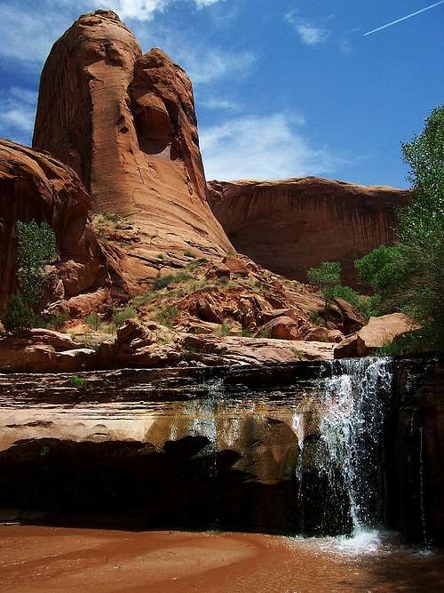
Needless to say, this is a harsh desert, so please drink adequate amounts of water.
Maps
--National Geographic Trails Illustrated produces a nice map for this area called Canyons of the Escalante Trail Map. Click here for the link.
USGS Maps
7.5 Minute—King Mesa, Big Hollow Wash, Sooner Bench
15 Minute—The Rincon
1:100,000-- It’s not on the Escalante, UT or Navajo Mountain, UT maps. Maybe there is none??
Wildlife
A great variety of habitats are found in this region. The desert plain and the canyons offer distinct communities of mammals, reptiles, birds and amphibians. Among the inhabitants of the desert plain you can find coyotes, jackrabbits, mice and rats, lizards, larks, sparrows and nighthawks. Inside the canyons bats will be a common sight. Mountain lions, deer, foxes, coyotes, mice and rats also can be found in this zone. Waterways, like the Escalante River, may be home of beavers, muskrats, ducks, great blue herons, egrets and hummingbirds. Frogs, toads and snakes are also common. Four subspecies of venomous rattlesnakes are present in the area.Get your Glen Canyon NRA wildlife checklists here:
D-bo - Feb 27, 2009 1:29 pm - Hasn't voted
New PhotosThanks to everyone who has submitted their wonderful photos to this page. Today I decided to update the page with these submissions. Enjoy!