
-
 30196 Hits
-
 84.27% Score
-
 18 Votes
|
|
Mountain/Rock |
|---|---|
|
|
38.64268°N / 122.58178°W |
|
|
Napa |
|
|
Hiking, Trad Climbing, Toprope, Bouldering, Scrambling |
|
|
Spring, Summer, Fall, Winter |
|
|
2462 ft / 750 m |
|
|
Overview
 Table Rock at the west end of the Napa Valley's Palisades.
 The American West is filled with formations with steep sides and flat summits dubbed Table Rock. These are joined by an even greater profusion of flat-topped monuments identified as mesas, Spanish for "table". The Table Rock located in Napa Valley is at once among the most obscure and one of the most interesting formations to bear the Table Rock moniker. Located at the northern end of California’s fabled Napa Valley, Table Rock maintains its silent vigil above the town of Calistoga, guarding the pass leading from the Napa Valley to the Clear Lake Basin. The best vantage points to observe Table Rock are brief vistas along Highway 29 as one climbs toward Saint Helena Pass. Table Rock can also be easily observed from numerous places around Calistoga.
Table Rock is a large block of igneous rock. Protruding from the mountains above Calistoga, it has sheer cliffs on three sides. The west face is the most impressive, soaring 150 vertical feet above the slopes below. This face has numerous excellent features for climbing, including good cracks and pockets of large huecos. Although not a sheer, vertical surface, the slopes beneath the south and west faces drop away at a rapid pace. This give the impression that Table Rock is much larger than it is. The north face is not as sheer as the west and south faces, but it contains numerous fissures that provide swift access to the base of the formation. Further below the north side of Table Rock is Garrett Creek Canyon. Garrett Creek has a perennial flow, but during winter and spring is respectably large stream. The walls of Garrett Creek Canyon are littered with smaller, craggy formations similar to Table Rock. Garrett Creek drains Bear Valley, a wilderness of hoodoos, badlands and other bizarre rock formations reminiscent of the Bisti Badlands in New Mexico.
 Mount Saint Helena viewed from the summit of Table Rock
Although it does have good climbing possibilities, the summit of Table Rock can be reached via a non-technical route. One can approach the formation via the Table Rock Trail, which departs across Highway 29 from the trailhead that leads to the summit of Mount Saint Helena. The top of Table Rock evokes images of a moonscape, pale and otherworldly. Numerous crags, gullies, and other unusual formations give the top a most unique appearance. Indeed, as stated previously, it bears some resemblance to various badlands found on the Colorado Plateau. Some areas are even reminiscent of pahoehoe, the thick ropy lava typical of the Hawaiian Islands.
As interesting and impressive as Table Rock may be, it keeps spectacular company. To the west Mount Saint Helena looms 2,000 feet above the summit of Table Rock. The mountain maintains a constant presence when one is in the Table Rock area, and there are numerous vantage points along the Table Rock trail of this most excellent Wine Country summit. Mount Saint Helena is not the only neighbor that requires mentioning. A short distance to the east of Table Rock are the magnificent Palisades, comprising a band of volcanic rock extending east from Table Rock for 2.5 miles. Together with Mount Saint Helena and Table Rock, the Palisades form an amazing skyline for Calistoga and the numerous wineries in the surrounding area. Table Rock appears to be an extension of the Palisades formation. While it is certainly true that Table Rock is an extension of the Palisades, it is considered its own formation by virtue of the 0.5-mile interruption in the cliff face between Table Rock and rest of the Palisades. The USGS considers it a separate peak.
Climbing On Table Rock
 The west face of Table Rock
Climbing beta for Table Rock is difficult to acquire. Nearby Mount Saint Helena has four well known climbing areas: the Bubble, the Bear, the Ganja Rocks and the Quarry. The Bubble and the Bear in particular are common climbing destinations. Table Rock is visible from these formations, and no doubt many climbers have looked to the east and wondered at the tall, mysterious cliff. Up close, anchors bolted in the face of the west cliff are clearly visible, so it is certain that climbers have spent time on it. However, the mountain has a reputation for having bad rock. Proprietors at a local climbing gym in Santa Rosa have hinted at this. First hand investigation has confirmed that the bottom 7.0 – 8.0 feet is indeed bad. However, above this band of crumbly rock there seems to be solid rock. The summit is certainly solid. There are numerous boulders and ledges at the base of the cliff that can be used to rise past the crumbly band at the base. Moreover, the rock that constitutes the nearby Palisades is akin to that which forms Table Rock and the Palisades rock is good. Conversations with State Park personnel have disavowed a formal condoning of climbing on Table Rock on the grounds of bad rock, but they do admit that people do it and there is no move to prohibit it.
Of course, anyone desiring to attempt climbing on Table Rock does so at their own risk.
Getting There
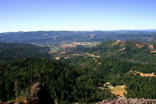 Napa Valley vineyards from the summit of Table Rock
From Calistoga, proceed north, out of town, on Highway 29. The highway immediately veers west and passes through numerous vineyards at the base of the mountains. Table Rock and the Palisades are prominently visible. Continue west on Highway 29 for a few miles. The highway will begin its tortuous ascent up to Saint Helena Pass. This road is EXTREMELY convoluted and many people speed up and down it. Care should be taken. Near the pass, signs will proclaim entry into Robert Louis Stevenson State Park. Immediately after these signs, turn into parking lots on either side of highway, the right side being preferred. From the parking lot, the trail departs to the east.
Red Tape
Table Rock is located in Robert Louis Stevenson State Park. The park is closed from Sunset to Sunrise. There is no backcountry camping. The backcountry around Table Rock is a checkerboard of public and private land. Although it is a wilderness for all intents and purposes, care should be taken not to intrude on any obviously private property.Robert Louis Stevenson State Park
707-942-4575
Camping
 Table Rock from the Napa Valley
There is no camping at Robert Louis Stevenson State Park. Moreover, there the park is closed from sunset to sunrise. This precludes any backcountry camping. The nearest public campgrounds are at Clear Lake State Park and Bothe-Napa State Park. Both these options are at least a 0.5 hour drive from the trailhead.
The Napa Land Trust owns the land east of the Palisades and they are negotiating the sale of 3,000 acres of land to the California State Parks for inclusion in Robert Louis Stevenson State Park. Once this transaction is completed (pending funding from the state, of course) the State Park intends to construct a few backcountry campsites.