
-
 14277 Hits
-
 85.36% Score
-
 20 Votes
|
|
Mountain/Rock |
|---|---|
|
|
40.54205°N / 111.68457°W |
|
|
Salt Lake |
|
|
Hiking, Mountaineering, Bouldering, Scrambling, Skiing |
|
|
Spring, Summer, Fall, Winter |
|
|
10719 ft / 3267 m |
|
|
A Quick Word About How This Page Came About
This page originally was created by SP Member d.shorb. Dan did an excellent job creating this page and the majority of it's contents will not be changed with the exception of a new photo or two here and there in the future. Eventually Wasatchvoyage claimed this page and after maintaining for years he passed it on to me.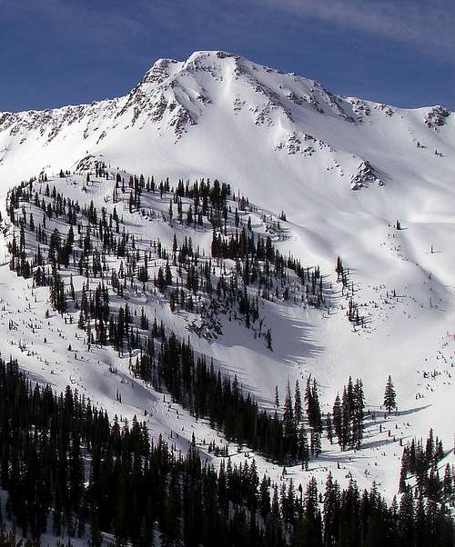 TyeDyeTwins perfect shot of the large east face of Lake Peak.
Lake Peak....Another cool Pink Pine Ridge gem
 edevart's photo of Point 10719 from Red Pine
This highpoint is a sweet place bathed in beautiful views of the surrounding mountains. Though it being a 'summit' may be in question, this place is noticed by all hard core Wasatch enthusiasts in all seasons.
It has many different names: referred to as No Name Peak in Tyson Bradley's Backcountry Skiing Utah book, this highpoint is now more often referred to by local guides as Lake Peak. MOCKBA points out that USGS maps have it as Thunder, and also notes it's known with many backcountry travelers as Pink Pine Peak. Whatever it is called this peaklet is worthy of the respect of a minor summit in its alpine setting.
It rises just north of White Baldy between White and Red Pine drainages, along the Alpine Ridge area.
Part of Pink Pine Ridge, it's slopes touch White Pine Reservior and Red Pine Lake (thus the name, Lake Peak). It has several couloirs and buttresses, that are most frequently skied rather than climbed, but that provide great scrambling. It's easiest access would be from the White Pine Trailhead, from either the White Pine Trail, or the Red Pine Trail, and can also be done as part of a Pink Pine Ridge traverse. The page author has done a White Pine/Red Pine loop, in both directions, over this peak, though cutting White Baldy out of a summer loop wouldn't make as much sense.
Pink Pine's Point 9947 is also worth attention: Point 9947 page
The Mountains around this ridge highpoint include:
1. White Baldy (south)
2. Red Baldy (southeast)
3. American Fork Twins/ Red Top (east) (see Joseph Bullough's great Alpine Ridge page for more info)
Getting There
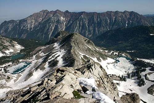
 PellucidWombat's awesome northeast view of Baldy and Pt. 10719
 Grandwazoo took this beautiful morning shot of pt. 10719
The main access point is the White Pine Trailhead in Little Cottonwood Canyon..
Though White Pine trail is the most direct, most hiker's have other objetives in the area as well, and, so, Red Pine may also be a nice choice.
Red Tape
 Pink Pine Ridge from White Baldy, with Pt. 10719 and its lakes on either side.
Note that PowderBirds do fly here in the winter, so always try to figure out if there's anyone above you when approaching this peak (even when there's no visible tracks). As PellucidWombat's picture (at right) notes, this is avalanche terrain.
Additionally note that this peaklet has 'wilderness' rules on its west side and normal forest service rules on its east side, because it is part of the Lone Peak Wilderness boundary.
The following are prohibited:
- Group sizes exceeding 10 persons.
- Camping within 200 feet of lakes, trails, or other sources of water.
- Camping for more than 3 days at one site.
- Short cutting a trail switchback.
- Disposing of garbage, debris, or other waste.
- Open fires in the Red Pine Fork
Camping
[img:391058:alignright:small:Lake Peak's SE couloir rising above White Pine Reservior][img:31104:alignleft:small:Grandwazoo took this beautiful morning shot of pt. 10719]As noted above, pt. 10719, and Pink Pine Ridge in general, makes up the eastern Lone Peak Wilderness boundary and different rules apply to those drainages.
The rules for this area say that you can camp anywhere 200 feet from any water source. Drainages are avalanche traps in winter anyway, so camp away from them even when melting snow. Also Don't Poop Within 200Ft. Of Water Sources.
External Links
Utah Avalanche CenterLakes on either side, this is a sweet photo by Marauders.
[img:115244:aligncenter:medium:Pink Pine Ridge from White Baldy, with Pt. 10719 and its lakes on either side.]Summit Views
[img:395843:alignleft:medium:Southern View][img:395828:alignright:medium:Northern view][img:395817:alignleft:medium:Western view: Red Pine, the Pfeifferhorn, and Thunder Ridge] [img:395837:alignright:medium:Eastern view, Snowbird Twins] [img:395833:aligncenter:medium:Southeast, Red Baldy]
