
-
 28222 Hits
-
 75.18% Score
-
 6 Votes
|
|
Canyon |
|---|---|
|
|
31.84304°N / 106.49001°W |
|
|
Hiking, Sport Climbing, Toprope, Scrambling |
|
|
Spring, Summer, Fall, Winter |
|
|
Overview
McKelligon Canyon is nestled on the south-eastern side of the Franklin Mountains, just minutes from downtown El Paso. Just a 10 minute drive takes you from a dense multi-cultural urban center to a rural desert environment. McKelligon Canyon is a popular destination for local rock climbing, hiking, and biking. Many people also use the Canyon to train for the annual Bataan Death March which is held at nearby White Sand Missile Range.Getting There
From Montana or I-10: Take Airway North and make a slight turn onto Airport. Airport becomes Fred Wilson and for 3 miles and then becomes Alabama. Follow Alabama to the left for .6 miles and turn right onto McKelligon Canyon Road.From Trans-Mountain/Loop 375: Take 54 W towards Fort Bliss, Exit towards Fred Wilson/Airport and turn right onto Fred Wilson. Fred Wilson becomes Alabama, follow it to the left and turn right onto McKelligon Canyon Rd.

Red Tape
McKelligon Canyon is part of the Franklin Mountains State Park and therefore subject to fees and restrictions from the Texas Parks and Wildlife Department.Rock Climbing
One of the best top roping and sport climbing spots in El Paso, McKelligon Canyon features numerous established routes ranging from 5.7 - 5.13c. The best source for information on rock climbing at McKelligon Canyon is vcrux.com.

Hiking
The Ron Coleman Trail leads from McKelligon Canyon to Trans-Mountain Road by traversing South Franklin Mountain. A minor diversion through the brush will lead to the peak of South Franklin Mountain.The trailhead is at the end of McKelligon Canyon Road in the back parking lot. It is recommended that you leave one vehicle at Smugglers Pass on Transmountain and then drive another to the trailhead at McKelligon Canyon.
From the trailhead follow the blue trail markers. Continue up and to the right past the first cave, then to the left past the second cave.
At 0.58 miles as you reach the ridgeline, turn right and follow the trail north.
At about 1.45 miles, there is a split in the trail. Follow the slightly lower trail to the left. The trail is hard to find over a few rocky areas that you will have to scramble over.
At 1.75 miles, you will climb a wall to The Window. At The Window, climb the left wall up to find the trail on the top.
Continue along the trail to the FAA towers, which are located on the peak of South Franklin Mountain. To reach the peak you have to detour from the trail and travel up to the towers. The descent is steep and loose.
Once back on the trail follow the ridgeline to the left down to the parking area at Smuggler's Pass on the crest of Trans-Mountain Rd.
The trail is strenuous in places and requires scrambling over rocks and steep inclines. Be sure to take plenty of water and give yourself The trail is 3.8 miles one way, not counting the detour to the summit. Give your self at least 3-4 hours to complete the hike.

McKelligon Canyon Amphitheater
Surrounded on three sides by dramatic canyon walls, the 1,500-seat amphitheatre, which is used for concerts and special events, is special feature of the park. For upcoming events at the McKelligon Canyon Amphitheater visit Ticket Master.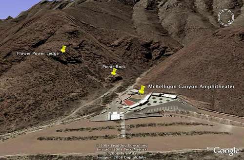
Other Activities
Many people use the paved McKelligon Canyon Road as a place to run, walk, ruck, or bike. Surrounded by the desert canyon walls and fellow outdoor enthusiasts, many find McKelligon Canyon a great place to get away from the city below and train for marathons and marches or simply to exercise outdoors.External Links
Franklin Mountains State ParkTexas Parks and Wildlife Department
VCRUX
Franklin Mountain (South) on SummitPost
Bataan Death March
Ticket Master