
|
|
Route |
|---|---|
|
|
39.19820°N / 120.2869°W |
|
|
Hiking |
|
|
Spring, Summer, Fall, Winter |
|
|
Most of a day |
|
|
Class 1 - Walk Up |
|
|
Overview
The Granite Chief Trail is a popular hike located northwest of Lake Tahoe. The hike to the summit involves 5.6 miles of hiking and 2850 feet of elevation gain. There are several websites and even books that claim this hike is only 9 miles round trip. However, both GPS and the trail markers indicate it is 5.6 miles to the summit.
While much of the trail is in the forest, the open areas are very beautiful, with rock cliffs and rock benches that are quite colorful. Because the trail starts at around 6,270 feet and ends at just over 9,000 feet, the trail takes hikers through a diversity of natural scenery. Views are excellent throughout the hike. Including views of the surrounding mountains all the way up, and then views of Lake Tahoe once the hiker reaches higher elevations.
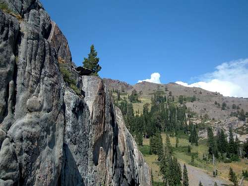 What a beautiful trail! Photo taken on the way down in August 2008.
Getting There
The Granite Chief Trail is pretty simple to get to, but sometimes a little more difficult to find once at the parking area. Getting there is easiest from Truckee and I-80. From I-80 head south on Highway 89 towards Truckee. Approximately 8.5 miles south of Truckee on Highway 89, there is a left turn (west) towards Olympic Valley. About 5 minutes up the road is the Palisades Tahoe ski area, which once hosted the Olympic Games in 1960. Before entering the Olympic Village, there is a right turn towards the Olympic Valley Inn. There is a large parking area, which tends to be wide open in during the summer, but is usually packed during ski season. Head towards the Olympic Valley Inn. To the right is the trailhead. It has enough room for about 10 cars. There are no markers and no bathroom and no indication that this is anything special. Trust me, this IS the start of the trail.
Route Description
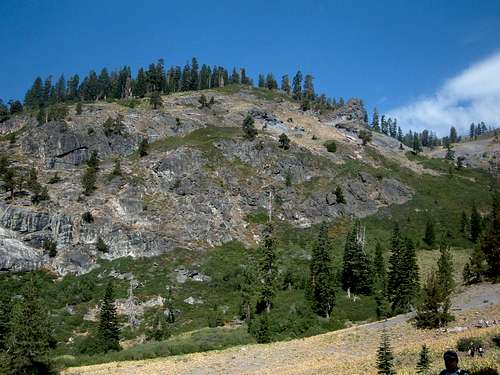
Start at the small trailhead next to the Olympic Valley Inn. Head west (left) up the main trail. After about 1/2 mile there is a trail sign that points the way to the Granite Chief Trail. Don't expect any other markers. Follow the trail as it heads generally north. The trail follows the right side of a creek. The creek was empty in August when we hiked it, but it was clearly a creek. Water does flow down the creek after snowmelt, but sometimes becomes dry during the summer. Continue up the trail as it enters an open slope. Here there will be the first wide open views of the mountains to the west, including the tram that heads up to the ski lift area as well as Granite Chief in the distance. Continue north up the trail further until you get to a cross over point at an elevation of approximately 7,300', seen in the photo below.
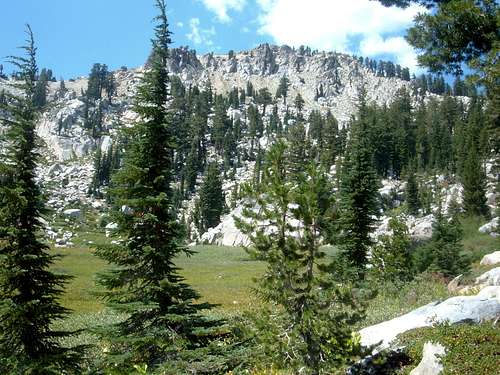
 The trail continues along the rock cliffs
Take the trail down to the base of these rock cliffs, cross the creek, and head west up the trail. Eventually there is an open slope of rock and no trees. This wide area provides wonderful views of the surrounding mountains, as well as Olympic Valley. Past this open area, the trail returns to the forest. Through this section, the trail continues to wind up switchbacks, heading generally to the west. About four miles from the trailhead, the Granite Chief Trail meets the Pacific Crest Trail (PCT). A sign points the way west (left) towards Granite Chief. Now there is only 1.5 miles to go. However, there is also approximately 1,000 feet of hiking still to come. The first 1/2 mile is generally level, with only a minor elevation gain. Soon Granite Chief is visible to the northwest.
 Granite Chief from the trail, with about 1/2 mile and over 700' of elevation gain to go to the summit.
Once at the meadow seen in the photo, follow the trail as it continues westward to the base of the final ascent. Head underneath the tram wires where a sandy trail begins up the mountain. The trail is quite steep, and the sand makes it slow-going. Eventually the trail has some rocks, making it a little easier. In about ten minutes, the summit is finally reached. Great views to be had by all!
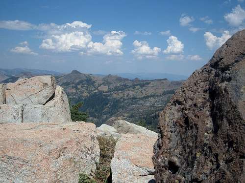 Tinker Knob from the summit of Granite Chief. One of the many great views from the summit.
Descend the same way you came. The steep sandy slope that makes up the final ascent is actually rather easy going down. The way down the mountain is quite a bit faster than the way up. Overall, the hike involves between 4½ to 6 hours of hiking for most hikers. The 2,850 feet gained in 5.6 miles makes this a moderately steep hike. Despite its lower elevation than some of its neighbors, like Mount Tallac, Mount Rose, and Mount Freel, this is quite a respectable mountain in terms of difficulty and should be treated as such.
Essential Gear
During the summer, a walking stick, bug spray, sunscreen, and good hiking shoes are required. During the winter, snow shoes are needed, but not crampons, unless it is very cold and icy.