
-
 3292 Hits
-
 74.01% Score
-
 4 Votes
|
|
Route |
|---|---|
|
|
34.27610°N / 118.0722°W |
|
|
Hiking |
|
|
Spring, Summer, Fall, Winter |
|
|
Half a day |
|
|
Class 1 |
|
|
Overview
This route to Barley Flats abounds in pleasant ridge travel and is a nice alternative to the standard trail route, although it is longer. It begins at the Red Box trailhead.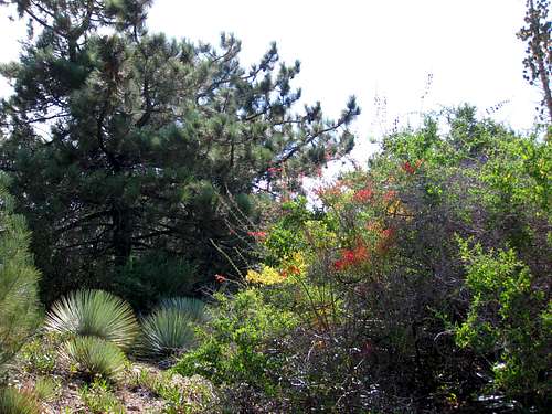 On Mt. Lawlor's east ridge towards Barley Flats
Getting There
From the 210 Freeway, exit at Angeles Crest Hwy (SR 2) and go north. At 9.5 miles, you will come to the Clear Creek Information Station and the junction with Angeles Forest Highway. Continue straight on SR 2 about 4.5 miles to the junction with the Mount Wilson Road at the Red Box Ranger Station. This is your trailhead and you will find plenty of parking here. Your trailhead for this route
Route Description
From the Red Box trailhead, cross the Angeles Crest Highway and go northeast along the highway for about 100 feet. Take the fire road that comes up on the left. Continue about ¾ of a mile to a trail junction. The trail going right is the Barley Flats Trail, an old roadbed. Continue left at the junction and follow the trail going past the very steep ridge just south of Mt. Lawlor until you reach the signed saddle between Lawlor and Strawberry Peak (elev. 5,200’). Here, you are 2 miles from the start.From the saddle, turn right (east) and head up the use trail on Lawlor’s northwest ridge about 0.6 miles to the summit. You will be afforded some great views of Mt. Wilson, Occidental Peak, San Gabriel Peak and Mt. Disappointment as you climb this ridge.
 San Gabriel Peak (L) and Mt. Disappointment (R) from Lawlor's NW ridge
From Lawlor’s summit, looking northeast, you will see Barley Flats’s long, forested ridge heading north to its summit. It is 2 miles from Lawlor’s summit to Barley Flats.
Proceed down Lawlor’s east ridge along a firebreak/use trail that connects with the Barley Flats ridge. You will go over three major bumps before you gain the Barley Flats ridge. As with Barley Flats’ tree carpeted ridge, Lawlor’s east ridge is lush with trees and beautiful flora.
 Mt. Lawlor's east ridge
Continue following the ridge as it turns north towards the summit. Presently, the use trail is greatly overgrown and you will lose the trail in a number of places. As you proceed, look west and you will get unique views of Strawberry Peak and Mt. Lawlor.
 Forested ridge of Barley Flats
  Strawberry Peak from Barley Flats ridge
Within about ½ mile of the summit, the trail peters out and you must start descending through thick forest. As you descend, bear to the left and you will eventually hit a road that leads straight to the green water tank and summit.
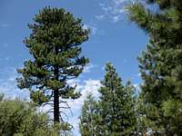
 Typical forest growth on Barley Flats ridge
A lock on the gate in front of the spiral stairs climbing to the top of the tank is usually left unlocked. Go through the gate and climb the stairs to the top to get additional great views of the area.
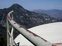 On top of Barley's green water tank
To return, you can either do this route in reverse, meaning that you will have 800 of gain to ascend Mt. Lawlor once again, or take the Barley Flats Trail, at 3 miles, a more direct route back to Red Box.
Essential Gear
As a Class 1 route, running shoes are perfectly adequate for your feet. However, because of the overgrowth along much of Barley Flats' ridge, long pants are advised.Red Tape
You will need an Adventure Pass or Golden Eagle Pass to park your vehicle anywhere within the Angeles National Forest, including this trailhead. These passes are currently sold at the trailhead you will use, the Red Box Ranger Station ($5 per day or $30 for a yearly pass). Otherwise, the passes are sold at most sporting good stores.No permits are required for hiking.
Other Information
USGS Topos: Chilao Flat 7.5External Links
Angeles National ForestAdventure Pass information
California Dept. of Transportation