
|
|
Mountain/Rock |
|---|---|
|
|
40.67443°N / 110.50605°W |
|
|
Duchesne |
|
|
Hiking |
|
|
Summer |
|
|
12124 ft / 3695 m |
|
|
Overview
Swasey Knob is a very mellow peak that sits at the southern end of the ridge lining the west side of Garfield Basin in the Uinta Mountains of Utah. The highpoint sits atop an almost flat plain 1.75 miles long by .4 miles wide scattered with red rocks amid clumps of yellow green grass. Swasey Knob lies ahead 1.1 miles away, the highpoint of a featureless plain
But, even though its top may be flat, its east side is a 600 foot cliff. Scenic Swasey Hole is below immediately to its southeast and many lakes can be seen from above.
 Swasey Hole
To its south lies bump 12007 whose southern ridge comes to a symmetric point, the sides of which seem to have identical coloring, red at the very top and orangish red down below.
 Heading toward 12007 on the way to Swasey Knob
At 12124 feet, Swasey Knob with prominence of 304 feet ranks 98th on Scott's list of Utah 12,000+ Foot Peaks with 200+ Feet Prominence.
Kings Peak (13528), Utah's high point lies 10 miles to the northeast. But the most striking 13000 footers viewed from this peak are Lovenia, Wasatch, and East Lovenia 7.8, 9.7 and 7.3 miles to the northwest.
 Lovenia, Wasatch, and East Lovenia
 Swasey Knob from the north Swasey Knob from the northThe summit is a 7.2 mile hike from the Center Park Trailhead to the south. It is so flat at the top that you might find it useful to know that the "x" on the map is at N40 40.466 W110 30.363. Most people would not want to climb this peak by itself but would do it as part of a multiday trip to several summits. The best months to climb are July, August, and September. |
Getting There
Access from the south is via the Center Park Trailhead.Red Tape
Group size is limited as per wilderness area rules. Many lakes have proximity restrictions. These restrictions change from time to time so check the sign board at the trailhead to see what restrictions are currently in place.Camping
There are 5 established campgrounds near the Center Park Trailhead as descriped in the trailhead page. There are numerous places to camp in Garfield Basin.Routes
From Center Park on the south Topo map Topo map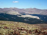 Yellow Benchmark from S ridge of Swasey Knob Yellow Benchmark from S ridge of Swasey KnobStart at the Center Park Trailhead and head north on the trail to Garfield Basin. After about 2.9 miles, leave the trail at N40 38.259 W110 27.603 and head for the 11193 benchmark to be found at N40 38.636 W110 29.439. Follow the ridge west and then northwest to the 11842 benchmark, the remains of which are found at N40 38.686 W110 29.439. Follow the ridge north to the 12007 bump and then continue another 1.1 miles on flat terrain to Swasey Knob (12124). For the return you could either retrace your steps or descend into Swasey Hole and make your way east back to the trail. A reasonable way to do this would be to walk the east ridge that starts just south of Swasey Knob until you reach the saddle between 11552 and 11337 and then descend south to Lake 10810. Pass south of Lake 10715 and Lake 10706 and then head east to the trail. |
Garfied Basin Rim Loop
There are seven peaks above 12000 feet ringing Garfield Basin and they all can be done in one trip. See Garfield Basin Rim Loop.