
|
|
Mountain/Rock |
|---|---|
|
|
40.28838°N / 5.13504°W |
|
|
Hiking |
|
|
Spring, Summer, Fall, Winter |
|
|
7297 ft / 2224 m |
|
|
Page optimized for a screen resolution of 1280 x 1024 pixels
Overview
 Peña del Mediodía seen from the East
 Peña del Mediodía seen from the West
The full name of this mountain is "Peña del Mediodía" (Noon Rock), or "Peñón del Mediodía" in some maps. It is the Easternmost important summit of the main sector of Sierra de Gredos, in Sistema Central. There are some other mountains with the same name in Spain and, in all cases, the reason is the moment in that the sun is seen just upon the summit. For that, we know that the origin of the name in that case is in the North slope, possibly in the village of Navarredonda, that was the most important population in the area in the Middle Age.
 View to the East
This mountain offers no chances for difficult climbing. The southern slopes are not rocky and the ground is too steep and unstable for direct climbings. The routes to summit consists in reach one of the three passes in the area (Peón, Cabrilla or Arenal) and go by the ridge. So, the appeal of this mountain is to be a good viewpoint; in the following link, you can find a 360º interactive panoramic view from summit. On the ridge section between passes of Peón (Spinning top) and Arenal (Sandy ground) there are several secondary peaks, with prominences under 100 ms (300 fts): Mojón de las Tres Cruces (Three crosses landmark), La Cabrilla (Small goat) and Andrinal (the ground where a certain kind of berry grows). But all these have not interest except as passage points.
 Paved road of Puerto del Arenal
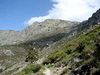 Going up to Puerto de la Cabrilla
The passes in this area have an additional interest as historical places. To the two main of them (Peón and Arenal) come roads even partially paved, which were built when to pay a tax was required for crossing with cattle or goods (from Middle Age to XVIII Century). The third one, La Cabrilla, was the smuggler’s choice and it's crossed by a correct footpath but not so good as the others. The three path crossing Sierra converge in Navarredonda, in the North side, and El Arenal in the South, which indicates the importance of both populations, small villages today, at past times.
 Sketch of Peña del Mediodía area
Getting There
 Peña del Mediodía false summit
 True summit
Depending from which side you want to climb Peña del Mediodía, you must first go to one of these villages.
- North: Hoyos del Espino, 175 kms away from Madrid, or Navarredonda de Gredos, 5 kms before in the same road. There is bus service from Madrid or Ávila to both; the company is CEVESA, phone 00 34 91 539 31 32. Navarredonda has more limited services but is possible to start the route in the same village.
- South: Arenas de San Pedro, 170 kms away from Madrid. There is bus service from Madrid or Ávila and you can find information about in the website of the Arenas de San Pedro town council.
In Hoyos del Espino and Arenas de San Pedro, there are shops, hotels, banks etc but bases of ascent can be up to 15 kms away, without other option to go on that a taxi or to walk. For that, the most advisable mean to get there is by car. You can see the most convenient route from your point of departure in the Michelin website.
Red Tape
No one in general, but:To do fire (in any form) is forbidden during the summer (july to mid-september) in woods.
In the north side, the route of Garganta de la Covacha pass through private lands. Passing by foot or even camp one night is tolerated but owners are not obliged to.
Camping and Huts
 El Arenal Village
North side: Camping in Hoyos del Espino, 2 or 3 km away from town, towards La Plataforma. Its website is www.campingredos.com.
South side: There are a free hut in Mingo Fernando (4 places, without commodities but clean). You can find some photos and a more accurate descripciton (in spanish) in this link.
Most Common Routes
 The famous "Peón"
North:
- From Navarredonda de Gredos, by Puerto de la Cabrilla or El Arenal. Elevation gain 800 ms.
- From Navarredonda de Gredos, by Garganta del Jabalí. Elevation gain 800 ms.
- By Garganta de los Conventos and Puerto del Peón. 700 ms.
South:
- From Mingo Fernando, by Puerto del Peón. 1,050 ms.
- From El Arenal, by Puerto del Arenal or La Cabrilla. 1,300 ms.
All of them are hiking routes and, except for Garganta del Jabalí, running by good roads. The two routes starting in any side can be combined as there are roads that connect bases of departure not exceeding 6 kms. Obviously traverses are also possible.
Really, there are some directs possibilities in the south face by Arroyo de las Malezas or Cuerda del Collado de la Huerta (Mojón de las Tres Cruces Souteast ridge) but they are unaccurate, exposed and non-interesting and I wouldn't advise it.
When to Climb
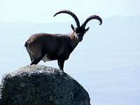 To meet Ibex is frequent
 View to the West
All the year, with the following cares:
- Snow persist usually untill early may and can appear at any time between october and january. A strong snowfall persisting a few days is possible one month before or after that period.
- In summer, it could be very hot and springs are sometimes dryed. Take it in account.
Other Practical Infos
For local weather forecast, visit the webpage of AEMET (Spanish government weather agency).Cartography:
Editorial Alpina, sheet "Sierra de Gredos", 1:40,000.
Editorial Adrados, sheet "La Sierra de Gredos", 1:25,000.