
-
 6257 Hits
-
 79.78% Score
-
 11 Votes
|
|
Mountain/Rock |
|---|---|
|
|
15.1789°S / 72.7861°W |
|
|
La Union |
|
|
Hiking, Mountaineering |
|
|
Spring, Summer, Fall, Winter |
|
|
15043 ft / 4585 m |
|
|
Overview
 Area Map
 Cerro Santa Rosa, from the South
 Village of Cahuana
 Cerro Santa Rosa From Above Achambi
 Company On the Trails
The top of Santa Rosa is a long ridge running northwest by southeast. The northeast side has steep shear cliffs making it look quite formidable, but the southeast end is an easy walk up. There are surprisingly few ruins on the top of Santa Rosa, only a few rock walls on the edge of one cliff and a number of circular rock walls on the east end. There are three main peaks on the ridge, and I haven't been to the mostly westerly one yet, so there could be more there. I am guessing that as much as the Incas liked the high places, with all the fertile valleys and lower peaks around it, there wasn't much reason to build a village up that high.
That doesn't make it a totally desolate or abandoned peak however. There are animal paths crisscrossing the slopes up to the cliffs on the northeast, and going all the way to the summit on the southeast side. This also makes for a great number of possible routes to the summit. I have gone up to the summit plateau from four different villages, two on each side. From there it is best to go around to the southwest side to reach the summit, unless you are prepared for serious fifth class rock climbing. The northwest end rises steeply from the Cotahuasi River, I have not tried that end yet but I would be surprised if there are not some possible routes there as well. On the southeast end of the ridge is the saddle that connects with the high plains, which looks like it might be another good way to get up there to approach Nevado Firura, the third highest mountain in the area (18,038 ft - 5,498 meters).
Getting There, Lodging
 The Trail Up to Cahuana
 Calla Ruins
 Calla Ruins Are On This Saddle
From Cotahuasi there are combis that leave for Alca every hour on the hour, starting at about 6:00 am. Look for the "Alca" sign in the windshield. These all go through Tomepampa as well as past Luicho Hot Springs (The Yumasca route), taking about an hour to get to Alca. The cost from Cotahuasi to Alca is three soles (2008). They leave Alca for Cotahuasi on the half hour, with the last one at 5:30 pm (sometimes 6:00 pm). If you return too late to catch the last combi, there are hostels in Tomepampa and in Alca. There is also a hostel near Luicho Hot Springs, right along the river. There are many hostels in Cotahuasi, see the Cotahuasi Canyon page.
The Routes
 Looking Up at Santa Rosa From Above Cahuana
 Looking Down the Main Trail To Cahuana
 Main Route Up Santa Rosa
 The Cattle Make Good Trail Guides
 Summit Ridge, Santa Rosa
The trail goes up the Cerro Cahuana side, separated from Santa Rosa, by a small river in the bottom of the canyon, and above the river by steep slopes going up to the mountain. At the top of the canyon it branches out into four smaller gullies, all of which have to be crossed to get to the summit. The first one is shallow and easy to cross; there is also a nice spring here and room for a small tent. The next three gullies are much deeper and you need to follow animal trails to find the routes to cross them.
Continue climbing up towards the east end of the summit using whatever trails are going in that direction. There isn't one good trail that went the whole way, but look for ones that have the yucca plants trimmed, which is an indication that humans use them as well. You will also need to find the best route up between some cliffs but it is fairly easy to see the best way to go. From the northeast, the summit is on top of a plateau, with a possible rock climb on the southeast end. The easiest way is to go around towards the southwest side, and you will soon find an easy walk up to the summit.
An alternate route to approach the summit from the north goes though the small village of Yumasca.
This trail starts at a shallow stream crossing on the main road to Alca, going east across the road from the entrance to Luicho Hot Springs. The trail follows the new road to Cahuana for a few minutes before starting a steep climb to the right up to Yumasca. (There is no scheduled public transportation to Cahuana and the road is rarely used.) Once reaching the plateau that Yumasca is sitting on, you need to aim for the left side of the visible peak of Santa Rosa, passing through the village and climbing up. The trail is hard to find and in general the villagers are not helpful to strangers trying to go up the mountain. It's best not to mention any ruins, just say you want to climb Santa Rosa and you may find someone willing to give directions. Depending on the trail you find, this will bring you out on the northwest end, or near the middle, of the summit plateau. It is easiest to go around the saddle on the northwest end and then go up the middle peak from the southwest, which is the summit.
 Yareta Near the Summit Plateau
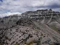 Summit Ridge, Looking East Toward Cerro Leonhuachana
 I Tried Going Down Here - No Good
To ascend from the southwest side, start at the village of Tomepampa, which is about half way between Cotahuasi and Alca. This is probably the shortest and most direct route, but the least interesting as well. Follow the quebrada east up from Tomepampa and then head up towards the summit, which will be off to your left a bit. Again there are many animal trails, but I don't remember any good trail, it is mostly cross-country. As you are climbing up towards the summit, keep a lookout for a natural stone arch on the other side of the shallow quebrada.
From Tomepampa, it is also possible to go up the steep climb to Locrahuanca to the right and then follow the trail east to Achambi, a higher village where lots of potatoes are grown. Continue east along the quebrada on the north side of Achambi and the trail will take you down to the stream at the bottom. After crossing the stream you will be going in the general direction of Santa Rosa. There is a trail going that way for a while, and then just head to the summit. For both of these routes, it is easiest to go towards the southeast end to get up to the summit ridge, although there may be a more direct route up the cliffs.
The last two of these routes are doable as reasonable day hikes. The second route, through Yumasca can be done as a long day hike if you find the right trails. The first option is best done as an overnight backpacking trip, taking time to explore the ruins on the way up and camping at the spring at the top of the canyon. Of course you can mix the routes as well, go up any one of them and come down one of the others. Or even make up one of your own! If you come down through Yumasca or Cahuana, Luicho Hot Springs is only a few minutes away. It is a nicely developed springs, with three different pools, temperatures and prices (one, two or five soles).
After The Climb
 After the Climb, Hot Springs
My recommendation is to at least go one way through Cahuana, and then make a side trip up the canyon between that and the village of Ayahuasi along the Chococo River. From the ruins follow the upper canal around above the village, going northeast towards Ayahuasi. There is a very delightful narrow path on the edge of the canal that will connect up with the main trail to Ayahuasi in about 20 minutes. Follow the main trail around to the right and it will climb up around a few cliffs, giving you great views of the quebrada and the terraced fields of Ayahuasi on the other side. Then it drops down to a small bridge crossing the river and starts to climb up again. Don't take the trail straight ahead (a minute later) but turn right and follow up the canyon on another beautiful Inca trail.
Follow this trail along the left side of the river, steadily climbing and meandering up the canyon. After 30 or 40 minutes the trail drops down to the river again, with a metal roofed adobe house on the other side. Just past here, behind a large boulder, is a small log bridge and then the trail climbs up steeply through some white rocks. In 10 or 15 minutes you will see another house on the other side of the river off to your left. Take the small trail going down towards that and the hot springs just below the trail. You may see a farmer or two in the fields here, as well as a few herders passing by on the trail. Unless you are here on a weekend, you will probably have the hot springs to yourself. Disfrutalo! (Enjoy it!) I have camped right alongside the pool, as well as in the grass over by the rock wall.
Camping, Water, Permits
 Good Camping
 A Protected Spring
You can camp almost anywhere outside of the villages, if you can find a level spot. The terrain is mostly mountainous, but there are flat spots around if you search for them. The lower areas are mostly terraced so there are many options there. Many of the terraces are abandoned or are pasture; I have never had a problem setting up my tent in these. There is little, if any, danger from the people, although I try to camp away from the villages, mostly because of the multitudes of dogs that are everywhere. I have camped in village plazas and the dogs have not bothered one bit during the day, but they come out and bark near the tent all night long. I also don't recommend leaving your tent set up alone during the day. I pack everything up and hide my pack somewhere if I don't want to carry it to the top. If you are interested in a cultural experience, ask in almost any village for a room to sleep in and someone is usually willing to take you in.
As everywhere in Peru, the water in the villages should be treated, even if they call it "agua potable". Some villages have running water, but it is not potable, I don't remember the word they use. You will be near streams and rivers much of the time, even on the mountainside. Consider EVERY stream contaminated, there are cattle, sheep, horses and burros in the seemingly most remote areas, as will be evidenced by the manure and tracks. Assume that there are animals grazing above that beautiful waterfall or up that steep canyon stream. You will most likely see them as you climb higher. The only time I trust the water is if I see the source of a spring flowing out of the ground or a rock. That said, there are many springs here as that is where all the water is coming from, you just have to trace it up to the source if you don't want to filter or treat it.
No permits or red tape of any kind.