
|
|
Mountain/Rock |
|---|---|
|
|
48.66024°N / 1.51234°W |
|
|
La Manche |
|
|
Hiking |
|
|
Spring, Summer, Fall, Winter |
|
|
157 ft / 48 m |
|
|
Overview
If it wasn't for it's location and approach, Tombelaine wouldn't be worth mentioning here on SP, as a meagre 50 metre outcrop of granite, 3.5 kilometres north of world-famous Mont Saint Michel.Tombelaine, Mont Saint Michel, Lillemer and Mont Dol (Dol de Bretagne) are ancient volcanic plugs, similar to those seen on the Clyde coast west of Glasgow (such as Dumbarton Rock), or in the Lothians, with one major difference; the plugs scattered along the Bretagne/Normandie border are igneous intrusive plugs, meaning that they formed below the earth's surface, and have only been bared because of erosion. The rocks in Scotland are all igneous extrusive rocks, meaning that molten lava made it to the surface.
Somewhere in the 10th century, some monk decided it was a great idea to built a church on top of the highest rock, and dedicate it to the Archangel Michael. (Every Saint Michael's church is built on top of the highest point in the vicinity)
From the 12th century CE, Mont Saint Michel started to draw more and more pilgrims which in the late 18th, early 19th century became more and more the mass-tourism fest you'll find here today. The hike to, and ascent of, Tombelaine will allow you to take in the beauty of the area, sans the madness of mass-tourism.
 Summit of Tombelaine
The Approach
Drive or take public transportation to Mont Saint Michel.Here is where the fun starts. Most tourists will enter Mont Saint Michel, and spend excessive amounts of money there, but Tombelaine is what Mont Saint Michel once was, before human habitation came. Also, this is probably the only object on Summitpost which approach is done barefoot on mostly quicksand. And that for 3.5 kilometres.

The approach needs to be done barefoot, and you need to set out at most 7 hours before high tide, if you don't want to race against the incoming tide, or involuntarily spend 5-6 hours on that rock.
Make sure you carry a backpack in which you can put your boots. You need them for the last bit, but you're sure to lose them on your approach.
By the gate of Mont Saint Michel, put your boots in your backpack and take your socks off. If you have convertible trousers, zip the legs off up until above the knee, otherwise take them off, and replace them with shorts, a kilt, or anything similar. Now you're ready to set out on the silt.
Walk around Mont Saint Michel, until you see the outcrop of Tombelaine. From here you may walk in a straight line towards it, but there are two tidal burns needed to be crossed. The first one you will reach within a kilometre or so, and is part of the outflow of the Couesnon River, the second is just before Tombelaine.
About 50% of the walk towards Tombelaine is over quicksand, which is generally not dangerous, unless one stops moving. Even if you get stuck in the quicksand, you won't sink away further than to about the waist, the problem is the tide which may reach 7-10 metres in some parts.
There are helicopters flying over Mont Saint Michel Bay, for this reason, still it's better to avoid it. If you start sinking, keep on moving.
 Mont Saint Michel seen from Tombelaine
Also, when crossing those tidal burns, the currents can be particularly strong at some places. Look for flat banks when crossing them, these will consist of quicksand, but that's less of a hazard than 3 metre/s currents in water that may be 6 foot deep.
Once you'll reach the south end of Tombelaine, look for a nice rock to sit upon and put your boots back on. The final hike/scramble will only take about 5 minutes, but will reward you with views 99.99% of the people visiting Mont Saint Michel will never see. Don't linger around too long though, you'll need to move 4.5 hours before high tide again to ensure safe passage across the bay. If the time until high tide is less than 3.5 hours, it's best to wait out the tide on Tombelaine.
Red Tape, Camping and Tides
No red tape, although the Mont Saint Michel tourist office discourages venturing out in the bay on low tide. You'll have to though if you want to get to Tombelaine. Also, when driving, be prepared to get your car out before the tide comes up.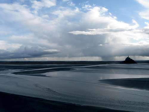 The vast expanse of mudflats during low tide
It's possible to camp on Tombelaine, and if you don't time your departure, you might be forced to camp there. It's recommended to leave Tombelaine 4.5 hours before high tide, and no later than 3.5 hours before high tide. Tides come up here fast, 7 metres in 1 hour. if you find yourself on Tombelaine less than 3.5 hours before high tide, it's best to wait it out.
Tide times and height can be seen on this website;
Mont Saint Michel Tourist office