
-
 17146 Hits
-
 87.31% Score
-
 24 Votes
|
|
Mountain/Rock |
|---|---|
|
|
44.75740°N / 109.3744°W |
|
|
Park |
|
|
Hiking, Scrambling |
|
|
Summer, Fall |
|
|
8673 ft / 2644 m |
|
|
Overview
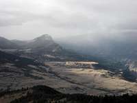 Sugarloaf and Antelope Mountains
 Clark's Fork Canyon
Dead Indian Hill sits near the top of the Chief Joseph Scenic Highway and overlooks Sunlight Basin, which is one of the most visually spectacular areas in Wyoming. Though not exceptionally high compared with its many neighbors that top 10,000 feet, this mountain is easily visible from a large part of the North Big Horn Basin. Its top is covered with large rocks and boulders, remnants of the volcanic activity that shaped much of this area.
 Summit ridge
The rugged pass near this mountain is where Chief Joseph led his band of Nez Perce Indians as they were being pursued the U.S. military in 1877. From Thomas Turiano's Select Peaks of Greater Yellowstone:
"The name 'Dead Indian' derives specifically from one or two incidents on an 8,600 foot mountain northwest of Cody, Wyoming. In 1878, General Miles attacked a small war party of Bannock Indians near today's Clark, Wyoming. The Indians retreated on a historic route over this high ridge, known today as Dead Indian Hill and Dead Indian Pass. Near the top of the pass, the defeated left behind a wounded warrior, who was scalped the following day by Crow scouts. Another legend recounts that a group of prospectors killed an Indian in a skirmish and propped up his body to warn other Indians of their intent to explore the territory at all costs. The name 'Dead Indian' then propagated gradually from Dead Indian Hill to Dead Indian Pass to Dead Indian Creek and finally to Dead Indian Peak."
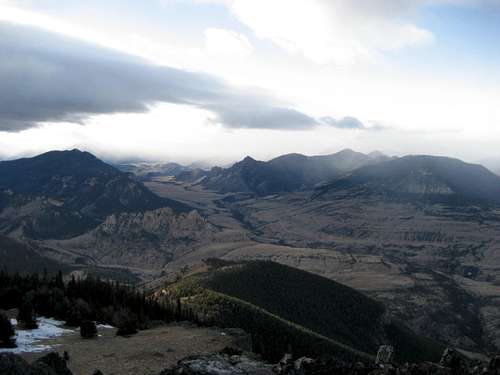
Prominent mountains seen from here include Dead Indian Peak (12,149), which is visible 15 miles away from Dead Indian Hill looking southwest. It is the rightmost of the two highest mountains, the one on the left being Trout Peak (12,244). On a clear day, Pilot and Index Peaks are visible, and the Beartooth Mountains are a stunning sight. There is also a great view of the Clark's Fork Canyon, which is seen down in the valley to the northwest.
 Sunlight Basin
Getting There
 Dead Indian Hill
From Cody, WY, take Highway 120 north for almost 17 miles, turn left on the Chief Joseph Scenic Highway, and travel for about 13.5 miles. You will see the radio towers on Dead Indian Hill and turn right onto the dirt road that leads up to them. You can drive to the towers with a 4WD vehicle or park at the gate (which is usually open) and walk.
 1933 Marker
 Near the third summit
As you walk past the towers, stay left and enter the large rock and boulder field; stay on the left ridge to reach the high point. The U.S. Department of Agriculture/Forest Service marker from 1933 is the affixed to the top of the highest flat boulder. This is the point marked 8673 feet on the topo map, but looking further north down the ridge from this point, there are two more summits that appear to be slightly higher. All three points appear within the same contour on the topo map, so I checked them using the elevation tool on Google Earth, which shows them all within five feet of each other, with the middle one slightly higher than the others. It is well worth reaching all three, especially since the third one requires some Class 3 scrambling to stand on top.
Reaching the top of Dead Indian Hill entails a 3/4 mile hike on the road from the gate to the radio towers, and a Class 2 scramble over the rock field for 1/2 mile to reach all three summits along the ridge. Total elevation gain is about 600 feet.
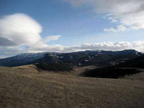 Lenticular clouds over Pat O'Hara Mountain
Red Tape
There are no fees or permits required to hike here. This is prime grizzly country, so carry bear spray and know what to do in case you encounter one.Camping
The nearest campground is Dead Indian Campground, which is located just off the highway to the right after the road descends down the other side of the mountain.External Links
Plaque on the scenic overlook from the highway:http://web.winco.net/~frankbay/raw/summit_text.htm
Geological Information:
http://gsa.confex.com/gsa/2008CD/finalprogram/abstract_135373.htm