
-
 9560 Hits
-
 85.87% Score
-
 21 Votes
|
|
Canyon |
|---|---|
|
|
42.83035°N / 103.57704°W |
|
|
Hiking |
|
|
Overview
 Some "toadstools" in the park
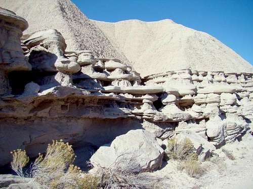 Canyon Rock Formations
One of the most scenic badlands areas in the USA is found in northern Sioux County, Nebraska. Toadstool Geologic Park is well-known for the “balanced rock” sandstone formations that resemble toadstools. The park centers around the canyon of Big Cottonwood Creek. Astonishing rock formations have been carved in the sandstone walls of the canyon. The entire area is rich with fossils, including prehistoric animals like hyaenodons and entelodons. It is illegal to remove any fossils from Toadstool Park. Before the major forest fires of 2012, this badlands area stood in stark contrast to the thick pine forests a few miles northwest. Big Cottonwood Creek Canyon, due to its lack of any significant vegetation, remained unscathed by those fires. There are two trails in the park. One is a 1-mile interpretive loop trail. The other trail, the Bison Trail, is a 3-mile trail that runs through the heart of the canyon south to the Hudson-Meng Bonebed, and archeological excavation site open to the public.
Getting There
 Bison Trail in Big Cottonwood Canyon
 Roundtop Peak and Cedar Canyon's edge
To get to the trailhead at Toadstool Geologic Park, travel north from Crawford, Nebraska on Highway 71 just over 4 miles to Toadstool Road, then follow the road for about 14 miles to the park entrance road. Toadstool Road is rough gravel road, and is very difficult to travel on in rainy weather. When you arrive at the parking area of Toadstool Park, you will find an old sod house, some parking spots, camping spots and a few picnic tables. There are also two vault toilets there. Trail maps are posted, and some handout maps are often available.
Red Tape
There should be no red tape, so long as you just pay your user fee, which is small. Removing fossils from the park is illegal, so keep that in mind while hiking. Please comply with all posted campfire and fireworks restriction. All campground regulations are posted. Trails are off-limits overnight.
Route Information
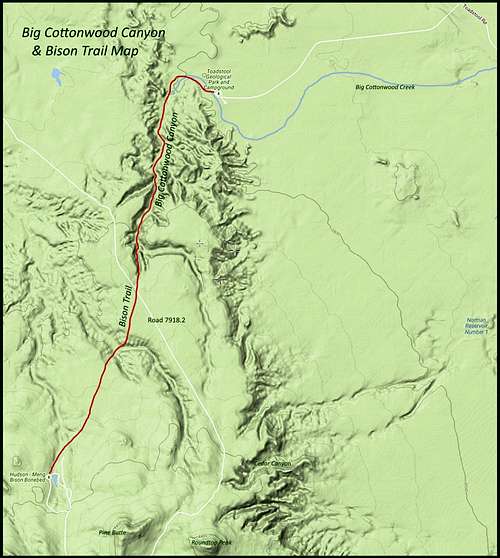 Big Cottonwood Canyon - Bison Trail Map
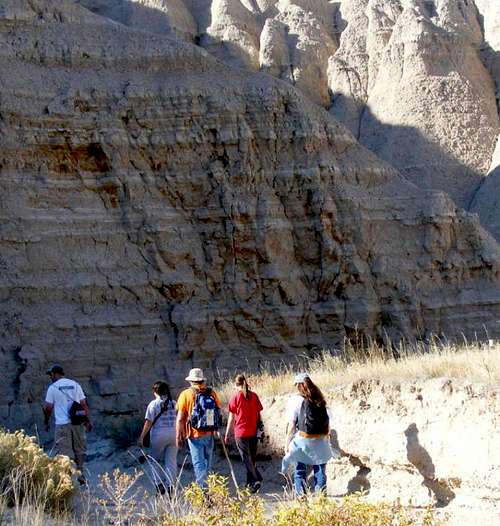 Canyon Explorers
Big Cottonwood Creek is dry most of the time, so the stream bed is used for the Bison Trail, which runs about 3 miles from the parking area in Toadstool Geologic Park, through the upper reaches of the creek bed all the way to the Hudson-Meng Bonebed. Around the midpoint of the trail, it crosses the divide between the White River and Cheyenne River watersheds, and drops into the upper reaches of Whitehead Creek. This is not very noticeable since it is so near the uppermost reaches of either stream bed and the terrain has softened from deeper canyon to simple badlands. Near the midpoint, the trail crosses Road 7918.2, which also provides a hiking option to Roundtop Peak and Pine Butte. At the end of the trail, hikers have the option to scramble up the sides and hike a short distance over to the Hudson-Meng Bonebed, choose a jaunt over to Roundtop Peak, skirting Cedar Canyon, or they can head back to the trailhead. The elevation gain from the trailhead to the high point of the trail is about 340 feet. Poor trail conditions always exist in rainy weather, making hiking the canyon not advisable until the trail dries out.
When to Explore
Because of the problems of poor trail conditions and very muddy roads on rainy days, visitors will want to keep up to date on the forecast & conditions. You can check these out at this link: Toadstool Geologic Park – Crawford Area Forecast & Conditions
Area Camping, Lodging & Other Resources
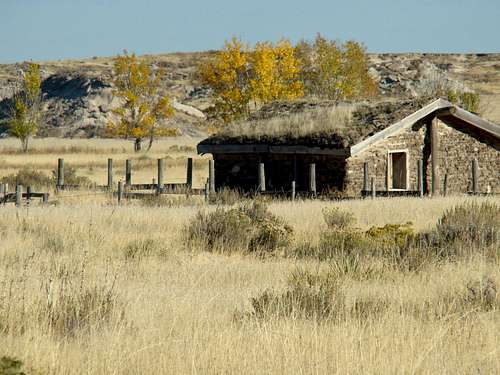 An old sod house in Toadstool Geologic Park
Limited camping is available at Toadstool Park. However, there is no water at the campground, due to a shallow, mineral-laden aquifer. So, if you prefer a campground with more conveniences, here are some links to more camping and lodging resources in the region:
 Narrow Side Canyon
Fort Robinson Camping & Lodging
Chadron State Park Camping & Cabins
Crawford Nebraska Hotels & Businesses
Safety
 Trail Hazard
 Hiking Crew on the Shelf
There are some hazards for hiking the canyon, but none so serious that caution and planning should not circumvent. Hiking the canyon in very warm weather can rapidly dehydrate a hiker, so pack plenty of water. Rattlesnakes are occasionally seen, especially in early morning and in evening hours. If you get off in brushy or grassy areas, bear in mind the abundance of ticks in the area, from March through August. Crossing the railroad tracks into Toadstool Park, requires one to be aware of the frequent trains passing through the area, often every 7 minutes. And, as previously mentioned, rain messes with the roads and trails. If you go out on the trail anyway, be prepared for slippery footing, and in some short stretches, sand and mud with the consistency of quicksand.