
|
|
Area/Range |
|---|---|
|
|
14.70039°N / 91.20002°W |
|
|
Hiking |
|
|
Overview
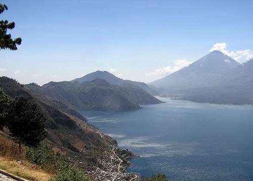
The Lake Atitlán area lies in the southwestern region of Guatemala. With a surface area of approximately 125 square kilometers and a depth of about 400m at the center, the lake and surrounding region is perhaps one of the most picturesque in Central America. It has been selected as a World Heritage Site by UNESCO. The word "atitlan" is a Mayan word that translates as "the place where the rainbow gets its colors." Indigenous communities live around the lake and more than forty archaeological sites have been identified.

Continued volcanic activity formed the three volcanoes that today surround the lake: Tolimán (3,158m/10,361 ft), Atitlán (3,557m/11,670 ft), and San Pedro (3,020m/9,908 ft). These volcanoes are joined by Cerro Chicul or Santa Clara peak (2282m/7,487 ft) and, on the western shore, Cerro San Marcos (2,538m/8,327 ft.) and Cerro Cristalino (1,712m/ 5,617 ft), subsidiary cones of the three volcanoes. See the topo maps below for more details on the peaks surrounding Atitlan.
Getting There
 Roadmap
Although Lake Atitlan is only 40 miles West of Guatemala City, curving roads and mountainous volcanic terrain result in about 100 miles of road and over 3 hours of driving time. The towns of Panajachel and Santiago Atitlan are the two primary arrival points on Lake Atitlan. They can be reached by bus, shuttle, or driving.

Buses
Buses leave for Atitlan from the capital on an hourly basis from the Rebuli in zone 1. Fare to Lake Atitlan will generally run about $10 per person, and will take 3-4.5 hours. For details on specific carriers, go to my page “Getting Around in Guatemala.”
Shuttles
Guatemala has a number of door-to-door shuttle services that service Guatemala City, Antigua, Panajachel, and Santiago Atitlan. These shuttles will meet you at the airport or your hotel and drive you directly to your destination (usually picking up a few more passengers along the way) in a van-sized vehicle with reasonable seating. They typically cost about $25 per person from Guatemala City to Panajachel.
Driving
If you are driving, you have a choice of routes. The highland route offers incredible vistas and some interesting scenery through wild windy roads. The coastal route provides straight well-maintained roads through the sugar-cane growing coastal plain of Guatemala, until finally climbing the back of the Lake Atitlan volcanic basin. Both routes take a little over three hours to reach Santiago Atitlan from the capital.
Communities and Villages
Thirteen towns or villages lie on the perimeter of the lake, mainly inhabited by traditional Mayan peoples with a sprinkling of foreign settlers. Below is a short introduction to a few of them.
PANAJACHEL
Panajachel (or Pana) is the town that most tourists visit. The complete name of this town is San Francisco Panajachel. It is a pre-Columbian settlement of Kakchiquel origin founded on the Panajachel river and at the lake's edge. It was the scene of the final battle between the Spaniards and their Kakchiquel allies against the Tzutujiles, and the site at which Franciscan friars founded a convent.
Pana is a great place to hang out and visit the local market. You can usually get whatever you need here in the way of supplies. Pana is full of restaurants, hotels, and tourists. It's a good starting place if you want to go visit other towns by boat.

Santiago Atitlan was the original capital of the Tzutujil Mayans. Built on the slopes of Volcan Toliman and Atitlán, is it surrounded on three sides by water and faces Volcán San Pedro across a small bay.
A unique blend of Mayan and Catholic religious beliefs and practices evolved in this village. The "Atitecos" ask "brujos" or witch doctors to beseech Mayan gods for help when they are sick or need rain while Catholic priests conduct services just as they would in Spain.
 Mayan god Maximom
Maximom lives in someone’s home for a year. Every year during Samana Santa (Easter week) there is a big procession and then he moves into a new home. Its easy to find Maximom, just ask any child where he lives. For a small tip they will be happy to introduce you.
SAN PEDRO
San Pedro is one of the two Tzutujil speaking villages on the lake, the other being Santiago Atitlan. If you are looking for something a bit less touristy, but still offers good lodging options and a places to eat (especially great Vegetarian food), then San Pedro is a good choice. San Pedro La Laguna attracts the greatest number of tourists after Panajachel and Santiago Atitlán, almost all of them young backpackers. The hotels and restaurants here are some of the cheapest in the country, and if you plan to climb Volcán San Pedro, this is the ideal base for an early-morning start.
SAN JUAN
Not many people stop in the Tz'utujil village of San Juan La Laguna. This makes it a great place to get away from the crowds and get a more authentic look at life on the lake. There are several artisan collectives in the town's center including a weaving co-op run by the village women. Their work is of the finest quality.The village is located a few km north of San Pedro.
SAN MARCOS
Surrounded by fruit trees, San Marcos La Laguna is known for its tranquil atmosphere. It attracts travelers who are looking for a peaceful spot to relax and center down. The town is most famous as the home of the Pyramid Center which is a magnet for meditating and alternative therapy enthusiasts. So if you practice Yoga, Reiky, or meditation, this is an ideal place to visit.
SAN ANTONIO
San Antonio Palopó, another 5 km from Santa Catarina Palopó, is a larger farming village and the bursts of color from traditional Mayan dress and the lively weekend markets are no less alluring. This is one of only a handful of regions in Latin America where men still dress in traditional costumes on a daily basis. Tunecos, as they call themselves, raise onions and anise in terraced fields extending up from the lake, which give the landscape a sculptural look.
Camping
Opportunities to camp in the Lake Atitlan area are pretty much limited to the volcanoes, hills, and to locations such as the following:
Hotel Reserva Natural Atitlán
This “reserve” is located in Panajachel and is part of the Hotel Atitlan facility. Hot showers, a restaurant, and access to the lake are available.
Private Nature Reserve Pachipac
Pachipac is located in the village Novillero in the municipality of Santa Lucia Uspantán, Department of Solola. It belongs to the protected area of the Multipurpose Reserve Basin of Lake Atitlan. Contact Aurelio Chavez Cochoy, Tel: (502) 77234140 or (502) 77670407, E-mail: corazondelbosque@yahoo.com
Private Nature Reserve Monte Quina
It is located in the Santiago Atitlan municipality, department of Solola. Contact Thomas Nottebohm, E-mail: tnottebohm@macnutspatzulin.com
San Buenaventura de Atitlán Nature Reserve
This reserve is located in the town of Panajachel in the Department of Solola. Contact Ricardo Carlos Rivera Reynolds Ricardo Carlos Rivera Reynolds, Tel: (502) 2331-9711, 2332-2791 Ext. 101, E-mail: rrivera@intelnett.com