
-
 2825 Hits
-
 84.27% Score
-
 18 Votes
|
|
Mountain/Rock |
|---|---|
|
|
44.46430°N / 109.3152°W |
|
|
Park |
|
|
Hiking, Scrambling |
|
|
Spring, Summer, Fall, Winter |
|
|
7187 ft / 2191 m |
|
|
Overview
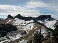 Summit View West
Located about 35 miles east of Yellowstone National Park, Point 7187 is the summit of the butte that is seen when facing south from the Sheep Mountain trailhead. This prominence makes up part of the northern wall of the Sheep Mountain mass, and the two canyons that run generally north-south on either side of its base provide the easiest access to the greater part of the mountain. The lower north side of Point 7187 is thinly forested, while the upper half of the mountain consists of a wide and very steep band of rocks. The south side runs gently down to a saddle which connects to the ridge that runs down the middle of Sheep Mountain.
 Point 7187
This summit offers outstanding views of the Buffalo Bill Reservoir and the Northern Absaroka Wilderness, as well as a spectacular 180-degree view of the alpine meadows and rock pinnacles on Sheep Mountain.
 Summit View Northwest
Getting There and Climbing Information
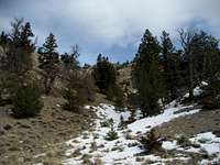 Gully on Sheep Mountain
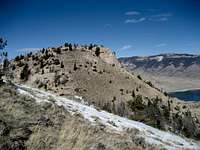
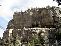 North Face of Point 7187
To get to the Sheep Mountain Trailhead, start from the traffic light at Wal-Mart in Cody and travel about 12.7 miles. This will take you through Shoshone Canyon and past Buffalo Bill Reservoir. There are signs marking the Sheep Mountain Day Use Area; turn left here and drive for 0.5 miles, turn left onto Stagecoach Trail, and drive for another mile. You will see a small sign on the right that reads "Sheep Mtn. Pit" across from the South Shore turnoff. Turn right at the gravel and dirt pit and drive up the road for 0.35 miles before parking at the sign at the trailhead.
Follow the two-lane track for a very short distance until a single trail splits off to the right. Take this trail, which will take you to the right of Point 7187, which is the butte that you will see in the center of the view looking towards Sheep Mountain. You will travel on a steep trail through a small, beautiful canyon with a spectacular rock face on the right of the valley that stretches up over 600 vertical feet. Once out of the canyon, the scenery changes from thick forest and rugged rocks to gentle meadows and wide open spaces.
The quickest way to the summit is to scramble 400 feet up the first gully on the left after you leave the trees. The route is slightly easier if you start heading up after a few hundred more yards on the trail; the main goal is to reach the ridge. Once on the ridge, head left up the remaining 200 or so feet to reach the top. The total distance to the top from the trailhead is about two miles, and the total elevation gain is 1600 feet.
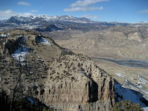
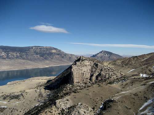 Shoshone Canyon from Point 7187
Red Tape
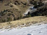 Deer on Sheep Mountain
The are no fees required to hike the Sheep Mountain Trail; however, the nearby fishing, picnic, and camping areas in Buffalo Bill State Park require a day use fee.
This mountain is teeming with wildlife; both black and grizzly bears roam this area, and mountain lions, elk, deer, and a large array of birds can found here as well, so bring your bear spray and stay alert.
Camping
The closest campground is the North Fork Campground and the North Shore Bay Campground is located a little closer to Cody; the two have a total of about 100 spaces.External Links
Information on Buffalo Bill State Park:http://wyoparks.state.wy.us/Site/SiteInfo.asp?siteID=3
http://www.wyomingtourism.org/cms/d/buffalo_bill_state_park.php
Information on Land Ownership on Sheep Mountain:
http://www.nature.org/wherewework/northamerica/states/wyoming/press/press2740.html