
-
 4352 Hits
-
 80.95% Score
-
 13 Votes
|
|
Mountain/Rock |
|---|---|
|
|
49.18667°N / 7.74730°E |
|
|
Sport Climbing, Toprope |
|
|
Summer, Fall |
|
|
232 ft / 71 m |
|
|
Overview
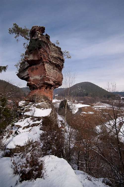 Heufelsen Main Summit above the Lauter Valley Heufelsen Main Summit above the Lauter Valley |
At the south-western end of the village of Hinterweidenthal in the Südpfalz Climbing Region you can find one of the many standalone formations of the vicinity - Heufelsen. Standalone, in this case, is relative - there is a big tower, which at its back is connected to a second summit via a narrow ridge. However, as the main summit is about twice as high as the other features it appears to deserve the standalone attribute.
The tower rises vertically out of the broad Lauter Valley. When driving B 427, the road which connects Hinterweidenthal with the town of Dahn in the south, it makes an appearance for the fraction of a second, then disappears again behind some trees. It took me quite a while and several tries until I finally managed to figure out the best approach, which goes right through the village. Once at its base you can only wonder what the trouble was about: two bike routes combine right underneath and several hiking paths do likewise.
 |  |  |  |
The Heufelsen main summit is based on a firm and broad foundation. The toweris slightly cone shaped and ends about 20m from the ground. Upon the tip a second formation is balanced precariously with a small foundation and a bulky body. Scramble to the top of the Heufels-Ridge and you get an idea. On the other hand - as the pictures on this page illustrate - the formation looks different from any angle.
The main summit of Heufelsen was first climbed in 1918 already by Südpfalz pioneers Otto Hartler and Jakob Otto.
Climbing Routes on Heufels
 At the base of Heufelsen Main Summit
The most important feature of Heufels is its main summit, which rises vertically out of the Lauter Valley. However, there are several more features, the routes of which are much less difficult, however.
Lately the main summit has been closed completely, due to rockfall on the south-east face.
| Feature | Routes link | Summary |
| Heufelsen Hauptgipfel | Heufelsen main summit | 10 routes with variations ranging from 3 - 8+ |
| Heufelskamm | Heufels Ridge | 5 routes ranging from 2 - 4+ |
| Heufelsen Westgipfel | Heufelsen Western Summit | 2 routes with variation ranging from 1 - 3+ |
| Heufelstisch | Heufels Table | 3 routes ranging from 3 - 4 |
Getting There
 West face of Heufelsen Main Summit
The Heufelsen are located a little south of the village of Hinterweidenthal For a brief second it is visible from B427, the road which connects the village to Dahn in its south. The best starting point is in Hinterweidenthal, either near the little train station or on the village square. You'll have to hike for about 5 - 10 minutes (just follow the road beside the railway tracks, which after a while crosses them and leads south-westward. There is a home for senior citizens near the end (right side) after which you'll see Heufelsen plainly.
Hinterweidenthal is pretty deep inside the Pfälzerwald area so itineraries from the nearest airports Frankfurt and Stuttgart tend to be lengthy:
From Frankfurt
There are two possible routes which both take equally long- Via Ludwigshafen
- From Frankfurt take motorway A5 southward to Darmstadt.
- There change to A67 south.
- At Viernheimer Dreieck turn onto A6 west.
- Leave it at Frankenthaler Kreuz for A61 south.
- At Mutterstädter Kreuz take A65 south until you reach Landau.
- At Landau turn on B10 west.
- At Hinterweidental turn onto B427 south and immediately follow the signs to Teufelstisch (right).
- Don't cross the railway line but search for a parking space near the crossing. The next one is to the right near the station, the village square is 200m further onwards to the left.
- Via Kaiserslautern
- From Frankfurt take motorway A3 west
- At Mönchhofdreieck turn onto A67 south
- At Rüsselsheimer Dreieck take A60 west
- At Kreuz Mainz Süd take A63 south
- At Kreuz Kaiserslautern turn onto A6 west
- At Kreuz Landstuhl turn onto A62 south
- At Pirmasens turn onto B10 east
- At Hinterweidental take B427, then follow the instructions above
From Stuttgart
- Take motorway A8 to Karlsruhe
- At Karlsruher Dreieck turn north onto A5
- Take the next exit to head for A65
- At Kandel you can leave onto B427 which will lead you directly to Dahn. However the detour to Landau and B10 will take less time as the roads are better (three or four lanes).
- At Hinterweidental take B427, then follow the instructions above
Red Tape
Yes, there is red tape and lots of it. The sandstone of Südpfalz forms lots of caves and overhangs. Though this makes it most interesting for climbers, two species of birds of prey compete for this habitat: the peregrine falcons and the eagle owls. Both are endangered and wherever there is a eagle owl pair found nesting in the sandstone the crag will immediately be closed. Generally this closure lasts from the beginning of each year through Aug. 1st. If breeding is not successful the closures will be cancelled even before that date. For a list of closures see the Closure List of PK. The Schillerfelsen are so close to the nearest houses of Dahn, that usually birds don't nest there. However, please adhere to "stop signs" if there are any.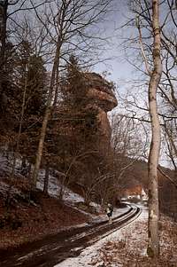 |  |  |
The use of magnesia is not allowed in the whole Südpfalz region. This is rather a directive or an arrangement than an outright law. Thus you probably will get away with using it but do so only when absolutely necessary. Magnesia closes the pores which you find in the sandstone and together they form a smooth surface which will get very slippery in wet conditions. The rule of thumb is to use magnesia in the highest difficulty sections and only extremely sparingly.
A list of guidelines can be found here (in German).
Accommodation
Hinterweidenthal has only a few inns and one hotel. The latter is to the east of the village on B10 and certainly is pretty noisy. A few kilometres to the south, at Dahn you can find everything that you need. See the following link:Dahn tourist information site
Dahn has a youth hostel and several campgrounds. The closest one is between Hinterweidenthal and Dahn at Neudahner Weiher.
Weather Conditions
Maps & Books
Maps
As for maps there is a good overview map (1:50000) by Kompass Verlag but the best ones are the official topographic maps by the state government of Rheinland Pfalz, scaled 1:50000, 1:25000 and 1:5000. All official maps can be found on the web page of Landesvermessungsamt Rheinland Pfalz
1:50000
- Naturpark Pfälzer Wald
Kompass Map WK766
ISBN: 3-85491-523-3
- Pirmasens Süd<
LVA RLP Map L6910
ISBN: 3-89637-193-2
1:25000
- Dahn
LVA RLP Map 6812
ISBN: 3-89637-147-9
Books
There are a number of climbing guidebooks on the region of Südpfalz. The best ones, however, have been published privately and are sold only in selected bookshops of the region.
- Hiking
- Pfälzerwald
B. & J.-Th. Titz
Rother Verlag
ISBN: 3-7633-4268-0 - Klettern im Buntsandstein
U. Daigger, H.-J. Cron
Westpfälzische Verlagsdruckerei St. Ingbert
ISBN: 3-00-0155457-4
- Pfalz - Klettern im Buntsandstein des Pfälzer Felsenlands
J. Richter, S. Tittel
Panico Alpinverlag
ISBN: 978-3-936740-41-7
- Pfalz ++, Klettern im Buntsandstein
R. Burkard, P. Weinrich
Published privately
- Klettern im Naturpark Pfälzerwald
Naturfreunde Lambrecht
Published privately - Pfalz & Nordvogesen en bloc
A. Wenner, Y. Corby, I. Bald
Panico Verlag
ISBN: 3-936740-19-4
  Climbing Guidebook |
Climbing