
-
 6663 Hits
-
 88.19% Score
-
 26 Votes
|
|
Mountain/Rock |
|---|---|
|
|
34.01372°N / 116.16892°W |
|
|
Riverside |
|
|
Trad Climbing, Sport Climbing, Toprope |
|
|
Spring, Summer, Fall, Winter |
|
|
4273 ft / 1302 m |
|
|
Overview

West Face
I’m not sure how this formation got its name, but it sure lives up to its reputation. The climbs on the north face are at a higher level of difficulty, making them out of the reach for most climbers. And the climbs on the south face, well, they are more manageable. However, they still don’t get as much traffic as you would expect. During my last three visits to Sport Challenge Rock, I didn’t see anyone climbing on the south face, let alone on the more difficult north face. And, these visits were during the peak climbing season. I wonder what has happened to the Crofts and Suzukis of the world! They would have soloed most of the routes on Sport Challenge Rock before breakfast.


Clean And Jerk, 10c is the obvious crack on theleft.

Leave it To Beaver follows the chalk marks.
When you look at the profile of Sport Challenge Rock you realize how overhanging the north face really is. The easiest climb here is a beautiful crack called “Clean and Jerk, 10c” and the difficulty jumps to 5.11s and higher from there. There are such classic climbs as “Leave it to Beaver, 12a” and “Cool but Concerned, 11c.” There are also several top ropped climbs in the 5.12 range. Many climbers leave leading the climbs on the north side to better climbers.
Climbs of The East Face

| Climbs of The N. East Face | |
| A | Clean & Jerk, 10c |
| B | Cool But Not Too Concerned, 11c |
| C | The Lobster, 12a |
| D | Leave it Beaver, 12a |
Climbs of the West Face

Being vertical, it’s only the south face of Sport Challenge Rock that offers a few more manageable climbs, and I found even those harder than their grade would indicate. However, climbs on the south face are moderate enough for a mid level climber to contemplate leading any of the routes. However, if you find yourself not in the mood for danger, getting to the top via the east shoulder seems to be a reasonable way for setting up an anchor for top roping.
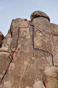
| Climbs of The West Face | |
| A | Sphincter Quits, 5.9 |
| B | What's It to You, 10d |
| C | Sport Climbers Are Weak, 11c sandbag |
| D | Ride A Wild Bago, 10a |
Camping and Noise Considerations

Joshua Tree Camping
Noise considerations,
When you are camping with friends and sitting around the fire, it is easy to forget that there are other people trying to sleep in the nearby campsites. It is important to put yourself in their shoes. Keep the noise and music to a minimum and certainly not too much past 10 p.m. Your neighbors will smile at you in the morning instead of giving you dirty looks.
For current Campground information please see the link bellow:
Environmental Considerations
Please tread lightly. The Access Fund has gone to great lengths posting trail marker for approaches to many of the more popular crags. Do you best to stay on these trails, and where you are forced to use a different path, choose the ones that rain can mend in time. Drainages make for good trails where there are no established trails.Avoid stepping on native and fragile plants, and do not feed the coyotes. Coyotes are very much used to people and often hang around picnic areas and camp grounds in hopes of getting a hand out. It’s better to let them live their natural life.
How To Get There
From the western entrance to Joshua Tree National Park drive on Park Boulevard, formerly known as Quail Springs Road, for about nine miles to a major rock formation called “Intersection Rock.” Intersection Rock is a major landmark on the north side of Park Boulevard with ample parking for visitors and climbers alike. This rock, true to its name, sit at the cross roads to Hidden Valley Campground, Barker Dam Road and the road to Day use and picnic area.Turn right onto the road leading to day use area with a large parking lot and bathrooms. The Trail to “Real Hidden Vally” is obvious and starts here. This trail leads to “Nature Loop Trail” and “Real Hidden Valley.”
When you get to the Loop Trail take the right fork. After a few minutes you will see a large and steep blocky rock formation to your left. That’s Sport Challenge Rock.
Red Tape
There are no permits required to climb or hike in Joshua Tree National Park. However, there are fee requirements for entering and camping within the park boundaries.7-Day pass for each passenger car---$15
7-Day pass on foot, bicycle or motor cycle ---$5
Joshua Tree Annual Pass/non transferable---$30
Interagency Annual Pass---$80
Campsite fees are $15/night for Black Rock, Cottonwood and Indian Cove campgrounds.
The fees for the remaining campgrounds are $10/ night.