
-
 18576 Hits
-
 88.19% Score
-
 26 Votes
|
|
Mountain/Rock |
|---|---|
|
|
48.97751°N / 114.04793°W |
|
|
Hiking, Mountaineering |
|
|
Summer, Fall |
|
|
9406 ft / 2867 m |
|
|
Overview
If the chief measure of a mountain’s worth were the number of lakes visible from its summit, Chapman would unquestionably rank among Glacier’s finest. Certainly one of the most scrambler-friendly peaks among its peers in the splendid but daunting northwest boundary region of the park, Chapman most notably commands vertiginous birds-eye views of Lake Cameron’s gem-like neighbors, Nooney, Wurdeman, and Carcajou; elsewhere in view along the climb are Bowman, Francis, and Upper Waterton Lakes, among countless other unnamed but no less spectacular ponds on both sides of the international border just north of the summit ridge.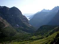 Bowman Lake as seen on the ascent, with Numa Ridge to its R. and Thunderbird Mtn in the L. foreground
Chapman’s peak-gazing opportunities are similarly remarkable in all directions: Custer and Thunderbird loom large in the foreground, while the behemoth Cleveland hovers not far away. With good visibility, expect to pick out some of the more conspicuous profiles in the Many Glacier and Logan Pass-area skylines.
Some discouragingly slippery talus and a curiously fecund population of flies at the summit are the small price you pay for it all.
 Looking north from the summit into Waterton. From left, Lakes Cameron, Nooney, and Carcajou
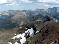 Following the ridge to Olson Mtn (R) and Campbell Mtn (L) down to Upper Waterton Lake. From the farther distant right, Cleveland, Chief, and Goat Haunt, among many others
Getting There
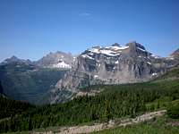 The Sentinel (snow-covered in the right foreground). One of many fine over-the-shoulder views during the climb
 A view from the trail near Brown Pass. From the upper left, Boulder Peak, the Boulder Pass area, and the outer edge of the Hole-in-the-Wall cirque
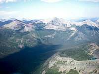 From the summit, north across the border into Waterton. From L., Mts. Carthew (in partial shadow), Alderson (the tallest) and Richards
The Route
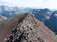 Chapman's summit ridge, with Cleveland in view to the far L.
Edwards includes two routes: a north face route--which poses the technical challenge of glacial crossing and the bureaucratic challenge of off-trail border crossing—and a far more readily accessible west slope route. To his sparse but adequate west slope route description I offer some supplementary detail:
From roughly the juncture of the Boulder Pass trail with the entrance to the Brown Pass campsite, scramble up any one of the several drainages that scour the mountain’s southwestern face. About two-thirds of the way up the mountain you will encounter a band of cliffs (class 3, although quite rotten in some places); work your way through them until you reach the final ridge and enjoy a scenic final stroll to the summit cairn on the easily discernible highpoint. From trail to summit you gain about 2,900 ft.
For a somewhat gentler way home, continue westward from the summit (in the direction of towering Custer) until the ridge descends abruptly into a very pleasant meadow. From there it’s a straightforward descent back to the trail. (N.B. If you are camping at Brown Pass, you may want to keep an eye out for the seasonal streams that materialize along the lower portions of this route, as it’s a surprisingly long and rather less scenic hike to the water source at the campsite.)
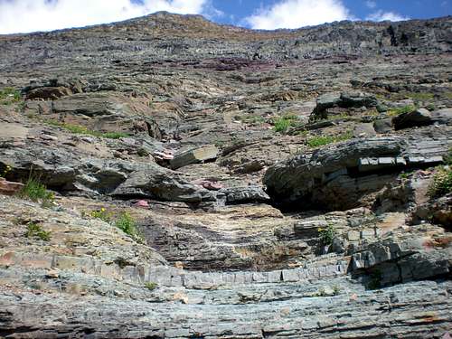 A grand staircase up Chapman
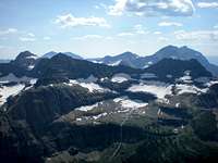 Thunderbird Mountain and Glacier across the valley from Chapman. Beyond and to the right (in the haze), Mt. Carter
 Chapman's western slope seen from Brown Pass, with several promising drainages visible
Precautions
Pack enough water to last the entire climb; once you leave the streambeds near the base of the mountain, you are unlikely to encounter more than the occasional trickle of snowmelt, and sun exposure is maximal along the entire route.Observe all the usual bear-country precautions.
Red Tape
 Porcupine Ridge and its double visible on the haul out to Goat Haunt
 Lake Wurdeman vertigo
 Chapman (far L.) seen from Boulder Peak. Thunderbird Mtn. on the R. across the valley