Your object was successfully created.

-
 22991 Hits
-
 87.76% Score
-
 25 Votes
|
|
Mountain/Rock |
|---|---|
|
|
36.16412°N / 115.42146°W |
|
|
Scrambling |
|
|
Spring, Fall, Winter |
|
|
4714 ft / 1437 m |
|
|

Overview
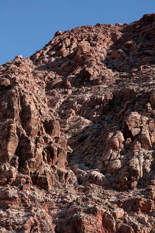
Kraft Mountain is one of several minor summits in the Calico Basin section of the Red Rocks area that offer short but enjoyable scrambling routes and excellent views of desert peaks and canyons. Calico Basin is just east of the beautifully colorful Calico Hills and can be used as an alternative approach to them if one wants to avoid paying the fee for the Scenic Drive in Red Rock Canyon National Conservation Area, which is the means of access most visitors to the Calico Hills use. Another drawback to the Scenic Drive and thus advantage in using Calico Basin is that the Scenic Drive is one-way only and the Calico Hills are accessed from points one to three miles in, meaning anyone who wants just to visit the Calico Hills must drive the entire loop road, where traffic can be infuriatingly slow on busy days.
On maps, Kraft Mountain is Point 4714, which is almost due north from the end of Sandstone Drive, where the parking area for Calico Basin is. Much of Calico Basin is private property, but a few locations accessible to the public do provide legal access to the mountains and canyons there. Always respect any posted property boundaries, though, lest landowners grow irritated and begin agitating for closure of these access points, something that happens all too often where private land abuts wilderness-quality public land.
Kraft Mountain is in the La Madre Mountain Wilderness Area. The name is an unofficial one but is not my own; my sources for the name are SP member MoapaPk and the guidebook Rambles & Scrambles: The Definitive Guide to Peakbagging Around Las Vegas by SP member cp0915; this book is a wealth of information on peaks within a day's drive of the Las Vegas area and has an extensive collection of route descriptions for peaks in Red Rock Canyon National Conservation Area. From the guidebook, I also learned that the mountain is also known as La Hija, Spanish for “the daughter.” In addition to that, I found out that the south side is known for bouldering opportunities and that there are technical climbing routes in Gateway Canyon (north side). Unfortunately, that book is now out of print.
This peak is nothing to brag about over beers in the evening, but it makes a great short objective if time is limited. During my April 2009 visit to Las Vegas with my 4-year-old son, I was looking for high-quality things to do early in the morning before my son woke up (we were staying with my brothers, so I wasn’t leaving him unattended) or with my son later in the day. Some other SP members recommended this and other peaks; their recommendations were spot-on.
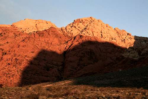
As the desert glows at dawn...
Routes
I know of at least four routes up the peak, two of which I have climbed; both of those are Class 3 routes. Consider using one route for your ascent and another for your descent in order to get to know the mountain better. Better yet, consider climbing this peak with the peak to its immediate west, New Peak; this will give you the option of two different routes on Kraft plus climbing a second peak during your outing, and the total distance can still be under three miles.
By the shortest route, the climb of Kraft is less than a mile and involves an elevation gain of about 1000’. The parking area’s elevation is about 3700’.
West Ridge
The west ridge was suggested to me by MoapaPk as the easiest way up Kraft; I used this as my descent route and found several short but enjoyable Class 3 sections and some minor route-finding challenges in places where the ridge cliffed out.
From the parking area, hike north along a trail until you meet a wider trail paralleling the south side of Kraft Mountain. Hike west until you reach a trail heading north to a pass between Kraft Mountain and New Peak. Hike to the pass, which is at about 4300’, and then head east up the ridge to the summit. There are some cairns to guide you if you need them, but you probably won’t need them.
South-face Chute
This route has several spots of Class 3, and you can make it harder if you want to; this is the route described in the guidebook mentioned above. As you hike west along the trail parallel to Kraft’s south face, you will notice three gullies or chutes on the south face. The first two, as viewed from right to left, appear to end in impassable cliffs somewhere around the middle of the face. The one on the left, though, close to the west end of the south face, goes all the way up to the summit ridge. Hike to that gully and then scramble/clamber up it. When you reach the top, the summit will be a short walk to your left (west).
North Face
Another suggested route in the guidebook is to ascend the north face from Gateway Canyon to a point somewhere west of the summit. I have no personal experience with that route but would go expecting at least Class 3 conditions. The book mentions a short dryfall near the bottom that some parties may want to rope up for. This is the longest of the four routes mentioned here.
East Ridge
Finally, I also know from a map someone shared with me that the mountain’s east ridge presents a feasible route. Again, I have no personal experience with that route but would go expecting at least Class 3 conditions.
Technical Routes
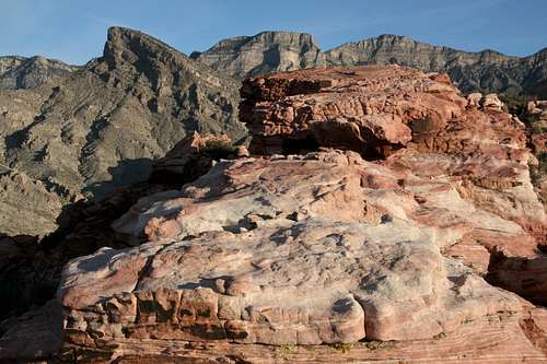
Summit View
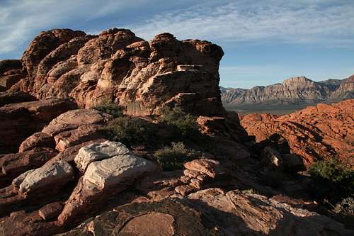
Summit View
Getting There
From Charleston Boulevard (Route 159) west of I-215 and Summerlin, turn onto the signed road to Calico Basin; this road is about one mile east of the entrance to the Scenic Drive in RRCNCA. Keep right when you reach the spur to Red Springs Picnic Area and soon bear left onto Sandstone Drive. Follow that road to its end; there is a large and obvious parking area on the left. The distance from 159 to the parking area is about two miles.
Red Tape
There are no fees for Calico Basin, but please respect property boundaries and posted wilderness regulations.
This area is unpleasantly and dangerously hot on most summer days. Climb here very early in the morning or at night if at all.
Camping
There are no campgrounds in Calico Basin. The area is best-suited for day hiking and climbing, anyway.
External Link
BLM site for RRCNCA