
-
 19035 Hits
-
 84.82% Score
-
 19 Votes
|
|
Area/Range |
|---|---|
|
|
44.74760°N / 109.48°W |
|
|
Hiking, Mountaineering, Trad Climbing, Scrambling |
|
|
Spring, Summer, Fall, Winter |
|
|
8071 ft / 2460 m |
|
|
Overview
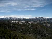
 Antelope Mountain Cliffs
Much of the northwestern part of the state of Wyoming is either National Park, National Forest, or Wilderness Area, and for good reason; some of the wildest, most rugged, and isolated places in the entire United States are located in the mountain ranges, canyons, rivers, and unique natural wonders that make up this area. Arguably one of the most beautiful highways in America, the Chief Joseph Scenic Byway runs through parts of the North Absaroka Range and gives breathtaking glimpses of the wonders that are found in this truly awesome place.
 Clark's Fork Canyon
Several forest roads turn off of the main highway and lead deeper into the wilderness; these are closed during the winter and generally open sometime in May. The most important of these is the Sunlight Basin Road, which heads west off of the highway near Dead Indian Campground. This road can be used to reach many of the peaks listed below, but keep in mind that the last few miles of this road are closed to vehicles for nine months out of the year to protect grizzly habitat. Opportunities for hiking and scrambling are found very close to the highway, and for those that want to explore farther away from the road, the options for peakbagging in this area are virtually endless, with everything ranging from half-day hikes on steep 7,000-foot mountains to multi-day approaches to peaks that soar over 12,000 feet.
The road is named after the Nez Perce leader Chief Joseph, who lived from 1840 to 1904. In 1877 he led his band of about 800 people through this area in a miraculous escape after being nearly surrounded by the 2,000 troops of General Howard. Trying to reach freedom in Canada, he and his people were finally caught about 40 miles from the border in the Bear Paw Mountains of Montana.
  |
 North Absaroka Range
 Sunlight Creek under Peak 9100
Getting There
 View from Dead Indian Pass
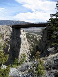 Sunlight Creek Bridge
Starting 17 miles north of Cody, Wyoming, the CJSB turns off of Highway 120 and heads west up over Dead Indian Pass, reaching an elevation of 8071 feet. Right at the top, there is a turnout with information signs and restrooms; the views from this overlook are nothing short of amazing. After this, the road descends seven switchbacks down into Sunlight Basin and generally follows Clark's Fork Canyon, ending where it intersects with the Beartooth Highway (212). While this is the official end of the scenic byway, the highway continues on to Cooke City and enters Yellowstone Park. The total distance of the byway is 46.3 miles.
One interesting attraction to visit on the road is the Sunlight Creek Bridge. This short bridge spans a 300-foot drop and is the highest bridge in the state of Wyoming. According to locals, it holds a world record relating to the ratio of its short length when compared to the depth of the gorge it spans, but I have been unable to substantiate this claim at this point in time.
 Cliffs on Antelope Mountain
Mountains and Peaks
This list shows the summits that can be reached during a day hike from the Chief Joseph Scenic Byway and the Sunlight Basin Road. The highest peaks in this area (not listed here) are situated south of Sunlight Basin and require much longer hikes to reach, both from this side and from the North Fork of the Shoshone side; these include Trout Peak, Dead Indian Peak, and Jaggar Peak, among others. Peak 9100
 White Mountain
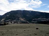 Dead Indian Hill
 Antelope Mountain
| Peak Name | Elevation | Prominence | Map Link |
|---|---|---|---|
| Windy Mountain | 10,262 | 2,042 | Map |
| Peak 9417 | 9,417 | 1,157 | Map |
| Peak 9371 | 9,371 | 471 | Map |
| Peak 9352 | 9,352 | 332 | Map |
| Russell Peak | 9,186 | 846 | Map |
| Peak 9100 | 9,100 | 1,120 | Map |
| Hunter Peak | 9,034 | 774 | Map |
| Peak 8885 | 8,885 | 345 | Map |
| Sugarloaf Mountain | 8,782 | 762 | Map |
| White Mountain | 8,763 | 383 | Map |
| Table Mountain | 8,761 | 301 | Map |
| Dead Indian Hill | 8,673 | 602 | Map |
| Peak 8639 | 8,639 | 379 | Map |
| Bald Peak | 8,633 | 1,053 | Map |
| Peak 8580 | 8,580 | 320 | Map |
| Peak 8420 | 8,420 | 360 | Map |
| Peak 8324 | 8,324 | 424 | Map |
| Little Bald Ridge | 8,100 | 360 | Map |
| Peak 7982 | 7,982 | 442 | Map |
| Peak 7700 | 7,700 | 400 | Map |
| Peak 7658 | 7,658 | 558 | Map |
| Peak 7460 | 7,460 | 360 | Map |
| Peak 7242 | 7,242 | 622 | Map |
| Antelope Mountain | 6,980 | 160 | Map |
| Peak 6942 | 6,942 | 402 | Map |
| Peak 6918 | 6,918 | 338 | Map |
| Peak 6804 | 6,804 | 344 | Map |
Thanks to the Lists of John site for the numbers.
 Sugarloaf Mountain
Red Tape
There are no fees to travel this highway unless you go all of the way into Yellowstone Park, which charges a $25 entrance fee. As mentioned before, the forest roads that branch off of the main highway are closed during the winter; all roads that are open to vehicle travel are clearly marked, and restrictions on off-road vehicle travel are also posted.There is some private property along the highway, so pay attention to posted signs; some of this property blocks the way up Antelope Mountain.
 Bear track
The North Absaroka Wilderness a wild place, and it contains thriving populations of grizzly bears, black bears, mountains lions, and wolves. Hike smart and carry bear spray, as the number of human encounters with these animals is rising; I saw tracks from two different grizzlies on a short hike not far from the highway.
Michael Hoyt - Jul 23, 2010 4:10 pm - Voted 10/10
Missed up displayTim, I think (but am not sure) that the thing which is messing up your page may be the panorama - not something you did, but the way SummitPost is trying to display it at the bottom of the page. To test my theory, detach that picture from the page. It will still display properly in your layout, but should no longer show up at the bottom. Just a thought... Mike
musicman82 - Jul 25, 2010 10:49 pm - Hasn't voted
Re: Missed up displayMike, Thanks - I'm sure that the problems started after I put the pano in there. I'm in Glacier NP this week, but I'll try it out after I get back home. If I can't get it, I may have you take a look at the code, if you don't mind... Tim