
-
 21040 Hits
-
 92.04% Score
-
 37 Votes
|
|
Mountain/Rock |
|---|---|
|
|
43.74116°N / 110.08584°W |
|
|
Mountaineering |
|
|
Spring, Summer, Fall, Winter |
|
|
10724 ft / 3269 m |
|
|

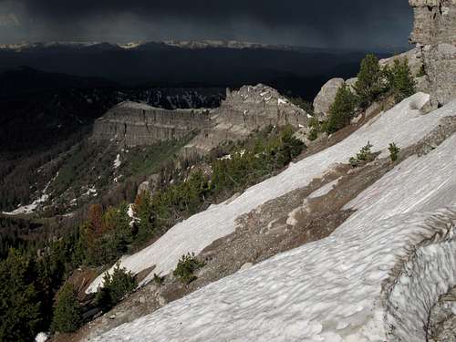
Views of the summit from various approach points...

By musicman82
Overview
Just south of Togwotee Pass is a high, isolated summit that stands out for miles as one drives along U.S. 287 from the west. The rocky western face of this small peak competes with the cliffs of Breccia Peak and Mount Sublette for travelers' attention, and although much of the rest of the peak is tree-covered, climbers will notice and feel drawn to the long, rocky summit ridge.
This is Two Ocean Mountain, which I have occasionally seen mislabeled as Tripod Peak by some professional photographers. Tripod Peak, however, is south of and lower than Two Ocean Mountain, and it is not visible from the road.
Two Ocean Mountain gets its name from the fact that it lies on the Continental Divide, the great wilderness spine that courses through the Rockies and determines whether drainages ultimately flow to the Atlantic or the Pacific Ocean. Interestingly, or so I think, the CD does not cross the actual highpoint; instead it appears to cross the breccia "tower" depicted in two pictures on this page.
For a mountain that is only about a mile from a major paved road, Two Ocean Mountain offers a remarkable feel of real wilderness. There are a few reasons for this:
• It is in Wyoming, which is one of the most sparsely populated states in the country (it actually has the lowest total human population and is 49th in population density, ahead of Alaska only).
• Despite being in sight of a U.S. Highway and only about an hour's drive from busy, world-famous Grand Teton and Yellowstone National Parks, it is in an area of the region that is relatively remote and lightly traveled in relation to some of the other human-used corridors.
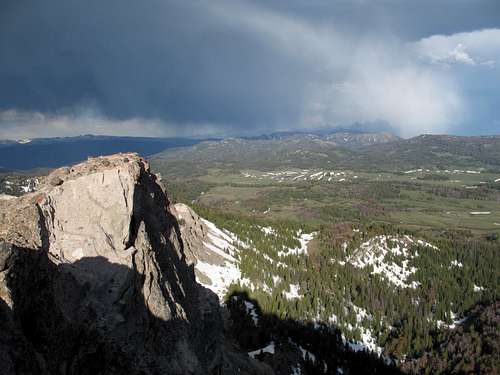
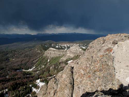
• It has views of some of the Greater Yellowstone Ecosystem's most striking and most important peaks in all directions, including the Grand Teton and Mount Moran; Gannett Peak, Wyoming's highest; Younts Peak, perhaps the most remote mountain in the Lower 48; the rugged, little-known Gros Ventre Range; the "Brooks Lake Cliffs" (Mount Sublette); and the Pinnacle Buttes, truly one of the most dramatic mountain complexes found anywhere in the country. So when one is atop Two Ocean Mountain, instead of noticing the nearby road, one is noticing the sea of mountains all around.
• It is in the Absaroka Range, itself perhaps the wildest and one of the most rugged mountain wildernesses in the country.
About that last point-- Togwotee Pass is the official meeting place of the Wind River Range and the Absaroka Range, but it is a nebulous transition, and many of the peaks in the area resemble the Absarokas far more in both appearance and makeup than they do the Winds. Being south of the pass, Two Ocean Mountain arguably belongs to the Wind River Range, but no one familiar with both ranges will doubt that Two Ocean is an Absaroka peak after having been on it.
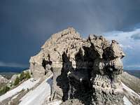
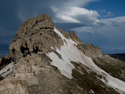
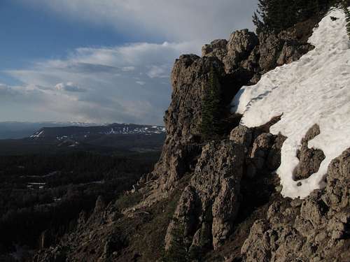
What pretty much cements (pun somewhat intended-- read on) Two Ocean Mountain's status as an Absaroka peak is the fact that its rocky summit ridge is composed of breccia, which is a dominant rock type in this area of Wyoming.
Breccia is rock composed of other rock fragments that have been cemented together. Though it sometimes is stable, breccia is often hideously loose even though it is beautiful to look at, as it often forms spectacular cliffs and spires. The rock often looks like a knob-studded conglomerate seemingly made for climbing, but those knobs pull out easily and frequently, making climbing on them treacherous. Some hardened Wyoming mountaineers refer to the substance as "kitty litter." The name fits, as anyone who has climbed on it can surely attest.
Breccia
The breccia on this peak is in better condition and is thus more reliable for climbing than on some other nearby mountains, most notably Sublette Peak, but do not fool yourself into believing this rock is trustworthy. It isn't. Don't jam a cam and go swinging away like Tarzan; if you do, you'll be taking the fast, hard way down the mountain.
Back in 2007, another SP member I met for a climb told me that the summit block on Two Ocean Mountain is technical, in the 5.3 range. Fortunately, he was wrong. I say fortunately not because the peak is a walk-up or an easy scramble-- it is not-- but rather because if it were technical, all but the best or most reckless climbers would never touch the summit, for protecting a climb on the rock here would be dangerous at the least and maybe impossible.
When To Climb
Because U.S. 287 is open all year, the mountain is accessible all year. I cannot speak to conditions, especially pertaining to avalanche danger, from late fall through early spring. I recommend late spring and early summer for climbing because the snow will facilitate the climbing through the forested areas. Although the fall hunting season offers some wonderful weather windows and whatever crowds that do hit this area are gone, there are enough hunting "accidents" in this country each year to make me discourage people from heading out in these mountains then, even if they (the people) are wearing the brightest orange they can find.
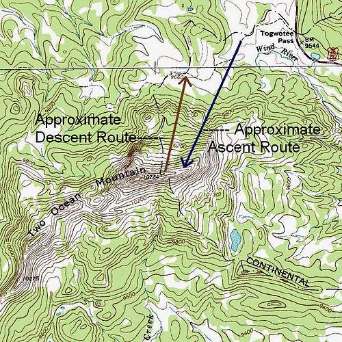
Getting There and Route Information
Approach view
Approaching the Peak
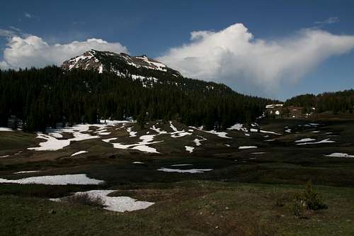
You pretty much have to be blind in order to not find this peak. It sits just south of Togwotee Pass and has nothing but subalpine meadows between it and the road. At a pullout on the south side of the road, look for a dirt road that heads off in the direction of the peak. This road actually winds for many miles into some of Wyoming's least-known road-accessible country, but the road can get one to within about a quarter-mile of Two Ocean Mountain.
Drive the road as far as you dare. In dry conditions, regular cars can go maybe half a mile before encountering some ruts and a stream crossing that will be too much for them. Vehicles with high clearance can go a bit further, but it will be difficult or impossible for unmodified vehicles to get as close to the peak as the road goes. In wet conditions, four-wheel-drive will be necessary.
When you park, make sure you do not block the road.
Wherever you do park, follow the road as much as possible on your foot approach to the peak; the boggy meadows are unpleasant to walk through and easy to damage.
The road distance from Togwotee Pass to the point closest to the peak is about 1.5 mi.
Climbing Details
If you start from Togwotee Pass and follow the 4WD road, the round-trip distance will be up to 6 miles. Subtract accordingly for how far along the road you can drive.
Elevation gain is about 1200'.
There is no trail. Expect bushwhacking or, if you're lucky, snow climbing through the trees to the long summit ridge. On the rocks of the upper ridge, including the summit block, the scrambling stays at Class 3 with some exposure at times, but it will take Class 4 or harder moves to reach the upper ridge itself.
You can directly approach the exposed rocks of the upper summit ridge through a combination of steep hiking/bushwhacking/snow climbing through forest that is moderately dense at best (though it could be much worse when the snow is gone and the undergrowth gets going) and hiking up loose dirt and scree-- this is the way SP member musicman82 and I descended-- but it will be exhausting even though it will be short.
Instead, we took an indirect approach. See the photograph at the start of this section as you read this description:
To get up, we approached the rocky face on the left (east face) but actually ascended through an open, snow-filled chute just right of it and on the north face of the mountain (the north face is what you mostly see here). The snow was at times steep, deep (postholing-quality), and slushy; however, it beat the other options-- dirt and deadfall (the dirt, when dry, was steep and hard, making it slippery, and in other places it was just mud). After that, it was a short distance along some snowbanks and rock/dirt sections to gain the summit ridge proper.
Photos of the approach to the summit ridge:
 |  |  |
You were able to see this formation from where you parked and have probably been thinking about it since. If you were thinking that it looked technical, you were right, but the good news is that you don't have to climb it; the bad news is that you must bypass it, and both options for doing so involve aspects that will unnerve some climbers.
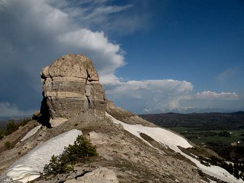
The "tower"
I scouted the right-side bypass from both ends; it is doable, but you will be hugging the block and inching along a very narrow "path" that is on loose dirt and is inches away from a long, nasty fall.
The left-side bypass is much easier and has two options itself. The first is to drop a few yards and bypass it that way near the edge of the ridge. I thought conditions looked a little muddy, and I also hate giving back any elevation gained, so I chose the other option, which was scrambling along the edge of the block. In my opinion, exposure was not an issue, but keep in mind that perception of exposure is highly subjective. This was, in my estimation, easy Class 3, but there was plenty of loose rock, though it was not as terribly loose as some other breccia I have encountered in the area. Still, though, I easily pulled a large round stone from the conglomerate in order to demonstrate to musicman82 how unreliable and treacherous breccia can be. I repeat that I pulled it out easily; I am not a weakling, but I am no pro weightlifter, either, and I had no trouble at all pulling that rock out. This is what you deal with when you climb on Absaroka breccia.
After getting past the block, you'll find that the ridge narrows to the point that you have just two options: stop and say you got close enough, or find a way onto that upper ridge of breccia.
I hardly claim that my way was the only way or the best way, but on the next section of breccia ridge, I climbed a cleft close to the nearer end. Using stemming and chimneying moves, I climbed this pitch of maybe 10-12' without any trouble with the moves or the rock. I am calling this a Class 4 pitch, but keep in mind that there is little consensus on what defines Class 4; what one person calls Class 4 could be a tough Class 3 to another and low Class 5 to yet another.
Atop the ridge, you find a catwalk-like situation approaching the summit block. It was narrow, wide enough to accommodate both feet side-by-side though not much wider than that, but since it was just a walk, the exposure (significant) did not bother me; again, though, remember that perception of exposure is highly subjective. And remember that conditions can have an effect; had there been strong winds, I would have felt quite differently about the exposure.
At the end of the "catwalk," drop a few feet and then study a way up the summit block. I took one way up and another way down; both were Class 3 on somewhat loose rock. Remember-- do not blindly trust any of the nice knobs conveniently poking out from the "cement."
Final approach and summit block-- click for route details.
Topo Map
Views
From both the climb and the summit...

Red Tape
Nothing official pertaining to the mountain. Do be aware that this is grizzly country and that special behavior and precautions are in order.
Camping
The Falls Campground is located about 10 miles east on 287; it is a large CG with 80+ sites, and the sites fill first-come, first-served. Two smaller, prettier campgrounds are slightly longer drives away; take the well-signed turnoff for Brooks Lake and drive 5 miles to the Brooks Lake and Pinnacles Campgrounds. These campgrounds are also first-come, first-served, and they have around 20 sites each. Even on summer weekdays, the sites often fill by early afternoon, as the area is very popular with anglers.
Sleeping in your car at scenic Wind River Lake, about half a mile from Togwotee Pass, is also an option, as is sleeping in your car at the pass (probably too noisy) or along the 4WD road that approaches the peak.
More Information
Shoshone National Forest
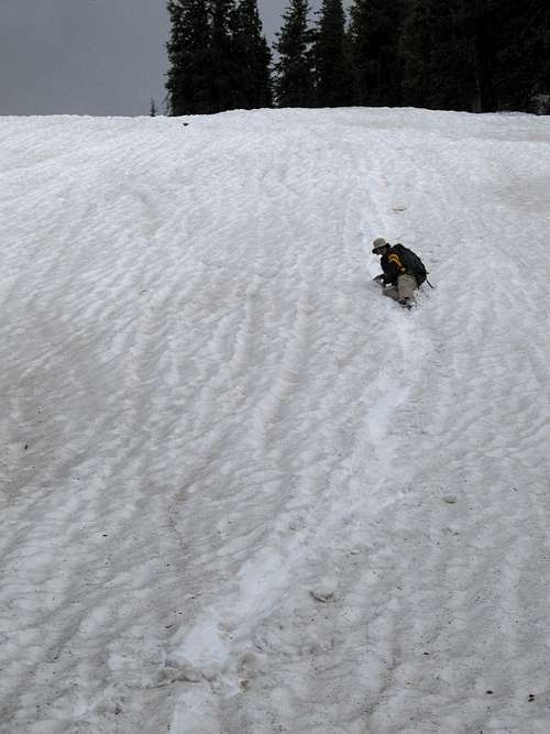
Glissade fun
eli.boardman - Jun 30, 2023 4:47 pm - Hasn't voted
True High Point: West vs. East Summit?On the question of whether the true high point is the eastern or western summit: Upon reaching the apparent top of this peak, where the LoJ and Peakbagger markers are located and where the map marks the summit, there is a small cairn of white rocks. Across a ~50 ft. gap to the west, there is a second summit of almost identical height. The eastern summit is class 4 via the route described on Summitpost, but traversing to the western summit requires down-climbing and re-ascending through the notch, which is low 5th-class on both sides and rather sketchy given the very loose breccia and significant exposure. I climbed both summits on 6/30/23 and sight-leveled with a SitePro 2.5x hand level from both summits. The results were indeterminate, but I can confidently say that the east and west summits are within 1 ft. of each other vertically. The eastern summit has a cairn that is about 6-8 inches tall, and neglecting the artificial arrangement of these rocks, I am pretty sure that the highest rock on the western summit wins out by a couple inches. If you count the cairn rock as the high point, then the eastern summit might be a couple inches higher. This peak is situated exactly in a tiny gap between existing USGS 3DEP LiDAR surveys, so LiDAR data are not yet available. Personally, I'd want to climb both the eastern and western summits to claim a definitive ascent, at least until someone drags survey equipment up there haha.
Bob Sihler - Jun 30, 2023 5:53 pm - Hasn't voted
Re: True High Point: West vs. East Summit?Thanks for sharing this, Eli. It was 14 years ago that I climbed this peak, and I don't remember having any doubts that I was on the highpoint, but then again, it was 14 years ago. I'll be back out there in about a week and plan to reclimb the peak after all these years, and I'll go with your observations in mind and will probably tag both summits.