
|
|
Mountain/Rock |
|---|---|
|
|
46.39520°N / 114.7304°W |
|
|
Idaho |
|
|
Summer, Fall |
|
|
8282 ft / 2524 m |
|
|
Overview
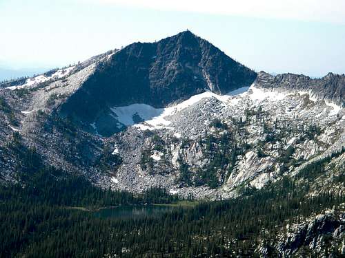 The north face of Grave Peak
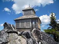 Grave Peak Lookout
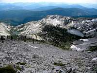 Grave Peak RNA
 Wind Lakes Basin
 Subalpine Larch
 Grave Peak and beargrass
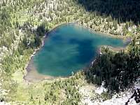 Colt Lake from summit
Grave Peak is an imposing, highly sculpted, three sided pyramid in the Selway Bitterroot Wilderness south of Powell, Idaho. Powell is about an hour southwest of Missoula, Montana. At 8,282 feet it is not high on most elevation lists; however it is a very significant mountain for a number of reasons. As a part of the overall Bitterroot Mountains, it is separated from the backbone of the main Bitterroots on the Idaho/Montana border by a broad expanse of lower mountains and large drainages that form the headwaters of the Lochsa River on the north and Moose Creek, the principle tributary of the Selway River to the south. Being entirely in the Clearwater Basin, it can be considered part of the expansive Clearwater Mountains, where it is the highest in that countless sea of summits excluding a handful of mountains on or directly connected to the Salmon/Clearwater Divide at the sub-ranges south border. It also has an impressive 2,502 feet of prominence.
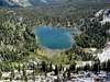
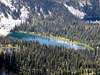
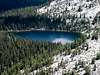
The three glacially carved faces of the summit pyramid fall into broad basins with multiple cirques and numerous lakes. The peak rises nearly 1,500 feet above the southwest basin, which has five lakes in two cirque basins. To the west they Wind Lakes basin contains four terraces ranging from 860 to about 1,900 feet below the summit. This basin has eight lakes or larger ponds. The north face of the peak is the most spectacular rising a sheer 1,300 to 1,800 feet above three lakes and a pond. The main rides extending from the summit have multiple cirques with a total of eleven more lakes. Altogether the slopes of Grave Peak support an incredible 29 lakes and larger ponds within a three mile radius of the summit. Most of these lakes are unnamed and shallow, but some are deeper and contain fish. The lower Walton Lake on the north end of the general ridge mass is said to be 265 feet deep.
Mountain is situated south of Powell and the actual flanks of the summit all drain into the Lochsa River, a primary tributary of the Clearwater River. Part of Friday Ridge that extends south from the summit drains into the Selway to the south. The general vicinity has a moist maritime climate and the lower elevations support groves of giant western red cedar, some reaching six feet or more in diameter. As the elevations increase the slopes are covered with various mixed conifer forests up to the subalpine, which is dominated by whitebark pine and subalpine fir. Open expanses of heather and other subalpine sub-shrubs are frequent. The north facing cirques that are filled with snow much of the year contain stands of often stunted subalpine larch, a northern species that extends south in the U.S. to the Cascade, Selkirk, Bitterroot and portions of the main northern Rocky mountains. Snow fall is very heavy and larger cornices or north facing packs can last late into the summer or sometimes even yearlong.
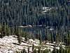
A lookout remains on the summit, one of the few survivors of hundreds of such structures that dotted the peaks of the northern Rockies in the early to mid-1900s. It was built in 1924 and abandoned in 1967. Though it has not functioned for many years, some private efforts have completed some minor repairs in an effort to maintain the structure. There isn’t really a summit register inside, but several miscellaneous papers lying around that people have signed. Of course many people have carved their initials in the walls and done some damage as well. Some miscellaneous food and supplies have been left assumingly for people to use if needed, but most of it appears to be very old.
The Grave Peak RNA was established in 1992 and covers 360 acres in the large glacier-carved, fire-scarred, rocky, subalpine cirque basin on the southeast side of the summit. Elevations in the RNA range from 6850 feet (2088 m) where the north fork of Swamp Creek flows from the RNA to 8282 feet (2524 m) on Grave Peak. The most striking feature of the RNA is the barren, granitic rock with very little soil development. Bedrock and talus, ranging in size from cobbles to blocks the size of a house, dictate the location of the forests. Vegetation of the area consists of typical northern Idaho subalpine vegetation, especially subalpine fir, whitebark pine, subalpine larch, Engelmann spruce, glacier lilies, and mountain heather. The forests are in early stages of succession having generated following the 1919 fire. Wetland vegetation of Grave Peak RNA is associated with a series of five subalpine lakes lying in two drainages. Three of the lakes are not associated with well developed wetland communities, and only 2 lakes support well-developed graminoid meadows.
The Lochsa Corridor along Highway 12 offers many things to do for those wanting to spend a little additional time in the area. The Lochsa River is famous for whitewater sports with numerous class III and IV rapids. The Lewis and Clark expedition spent time in the area from Lolo Pass, down to Powell and before ascending the mountains to the north and heading west on the most difficult part of their entire journey. There are several location markers and interpretative sites providing local details. North of Powell a few miles is the DeVoto Grove, a stand of giant western red cedar named for the famous author and historian who used to visit frequently for inspiration. At Lolo Pass there is a large Forest Service visitor center providing extensive information on the area. And downstream several miles there are popular undeveloped hot springs at Jerry Johnson and Weir Creek. Both require a very short hike and are day use only. Don’t expect privacy. The developed Lolo Hot Springs is a few miles north of Lolo Pass for those who don’t want to hang out with naked granola types.
Getting There
 The last two miles of the north ridge route.
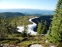 North ridge start
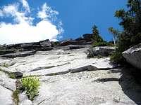 West side of razor
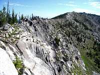 North ridge
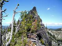 Razor from notch
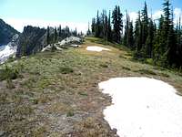 Last easy stretch
 North ridge from top
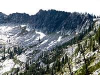 Razor section
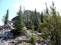 Notch to summit
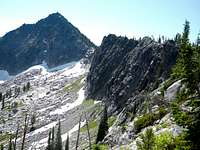 Summit and razor
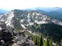 Towards Friday Pass
There are three primary ways to reach the summit. All three start with a turnoff of Highway 12 about 0.5 miles east of mile marker 163 onto the Elk Summit Road (Forest Service road 360).
Wind Lakes trail via Tom Beal Park
From Highway 12 turn south on the Elk Summit Road (360) and continue 1.2 miles to Forest Service road 362. Turn right on road 362 and continue for about 11 miles to road’s end at Tom Beal Park. Tom Beal Park is an area of open subalpine forest and meadows with good dispersed camping sites and multiple trailheads. The trail (7) to the Wind Lakes is signed and heads south across a meadow. From Tom Beal Park this trail slowly descends about 1,150 feet down Tom Beal Creek for about two miles where it meets the Wind Lake Creek trail (24). Turn left or east and climb 1,400 feet for about two more miles to the eastern most of the two larger Wind Lakes (elevation 7,111 feet). From here the southwest face of the peak can be scrambled through steep rocky tree tangled terrain for nearly 1,200 feet to the summit. Or one can stay on the trail (now trail 45) to the southeast and climb about 800 feet to Friday Pass, then follow the ridge north to the summit. From the lakes below this trail is about two more miles to the summit.
North Ridge via Walton Lakes trailhead
From Highway 12 turn south on the Elk Summit Road (360) and continue 1.2 miles to Forest Service road 362. Turn right on road 362 and continue for 8.9 miles to a turnoff to the left. There will be a small sign that indicates its 1.5 miles to Walton Lakes. Take the turnoff that ends at the trailhead for Walton Lakes after 0.1 mile and park. There are a few trails leading off through the trees to the south; most will wander around and end wasting time. The best way is to get on the east edge of the ridge and walk south along it. A good trail will soon form and continue for about 1.5 miles before ending near a broad ridge high point. The ascent is gradual and this is an extremely scenic hike through open subalpine forests and heavy heather thickets with an incredible view of the main Bitterroots to the east. At about the 0.75 mile mark the unmarked boundary to the Selway Bitterroot Wilderness is met.
From the rounded ridge point follow the main ridge west, then south toward Grave Peak. The ridge will be easy going most of the way, but near the mountain the east side of the ridge forms a vertical wall of impassable rock. Move to the west side and continue to the nook in the ridge at the base of the summit pyramid. Much of the west side will eventually form impassable rock, but with some minimal exposure one can pick their way across the bottom of most of it, yet stay above steeper slopes below. Once the nook on the main ridge line is reached, scramble up and over the blocky granite to the summit. The lower end of this reach is more difficult due to the very tangled stunted forest, but that soon diminishes making the ascent easier. The summit is 4.6 miles from the trailhead.
Road 358 via Elk Summit Road
From Highway 12 turn south on the Elk Summit Road (360) and drive about 15.25 miles to the junction of road 358, which turns off to the west. This road is about one mile north of where the Elk Summit Road crossed Bridge Creek. This road is open yearlong (or when snow will allow) for the first 2.2 miles. Then it must be walked for about a mile then it turns into trail 45. Continue on the trail for about four miles to Friday Pass, then go north for about a mile to the summit of Grave Peak.
 Heather parkland near the north end of the north ridge route.
Red Tape
None, other than standard wilderness regulations.Camping
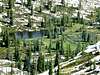
 Grave Peak above Colt Lake.
 Unnamed, (Colt north)
Good camping can be found at the trailheads at Tom Beal Park, Walton Lakes trailhead, and dispersed sites along the road into Kooskooskia Meadows. On the mountain itself any of the lake basins also provide good camping, though some are more difficult to reach. The Wind Lakes basin is reached by an approximately 4 to 5 mile (depending on which lake) hike on a maintained trail from the north and west. Swamp Lake is also reached by trail from Kooskooskia Meadows. The Colt Creek (north) and Swamp Creek (east) basins must be reached by mostly cross country hiking and descents to the lakes can be dangerous. Take time to pick a good path down from the high ridges.
 Wind Lakes
More general camping in the area can be had at a number of campgrounds in the lower country near Powell. The closest designated campground is at White Sands, which is about a mile south of Highway 12 off the Elk Summit Road. Powell Campground is located just past Powell Junction towards the Powell Ranger Station. Downstream a few miles, Whitehouse and Wendover campgrounds can be found. There is a minimal fee to use these campgrounds. Private cabins can be rented at Powell Junction. A list and map of all campgrounds and points of interest along Highway 12 can be found here.


When To Climb
Obviously summer and fall are the best times to reach Grave Peak. During the fall many hunters may be found in the area, especially camping in the lake basins and most of the summer the mosquitoes will be terrible, even up on the apparently dry ridges. Thunderstorms are frequent in the summer afternoons. As with any high mountain come prepared for a variety of conditions and watch weather reports closely.Generally the mountain gets no winter use, however snowmobiles may access the Elk Summit Road over Savage Pass and the first couple miles of the 358 road. Someone with snowshoes could get into the mountain or at least close from the east. The mountain slopes appear to be quite prone to avalanches however. Winter and spring snow levels are always heavy in these mountains.
Mountain Conditions and Information
Go to the mountain prepared for variable conditions. Grave Point rises nearly a mile above the lower elevations of the Lochsa River at Powell. Weather and temperatures can vary dramatically between the canyon and the mountain.Contact the Powell Ranger District of the Clearwater National Forest for information and current conditions.
Powell Ranger District
192 Powell Road
Lolo, MT 59847
(208) 842-3113
NOAA Forecast