
|
|
Mountain/Rock |
|---|---|
|
|
42.03504°N / 74.49664°W |
|
|
Ulster |
|
|
Hiking |
|
|
Spring, Summer, Fall, Winter |
|
|
3710 ft / 1131 m |
|
|
Overview
Big Indian Mountain, in the Catskill Range of New York, is one of the high peaks that people will hike to as part of the quest to reach all 35 mountain peaks in the Catskill region over 3500 feet in elevation. This mountain is one of the "trail-less" ones that make up the Catskill 3500 list, but there's an easily found herd path that goes right to the summit off the Pine Hill-West Branch trail. So there's really no bushwhacking involved. Yet the summit has a canister that holds the summit log, a feature on the peaks of the Catskill 3500 list where there really is no trail or herd path, and there is bushwhacking to reach the summit. On those peaks finding the summit canister can be an adventure, a reward to a tough hike, but that's really not the case on Big Indian, where there's a herd path right to the top, and the canister is easily found.The Big Indian Wilderness, where Big Indian Mountain sits, is one of the more remote and rugged sections of the Catskills. It has rough trails and mountains that do not reward you with good views like you would find on the Devil's Path in the Indian Head Wilderness. Therefore it does not receive a lot of visitors compared to other sections of the Catskills. If you're looking for some solitude, and some isolated wilderness then this is the place for you perhaps.
There are a couple of approaches one can take to reach Big Indian. Ultimately though you have to go on the Pine Hill-West Branch trail, which can be a real pain to hike on sometimes. The Pine Hill-West Branch trail has sections where the forest is taking back the trail, so it may not be hard as far as steepness goes, but it's not that fun to keep pushing tree branches out of your face. From the southern end of the Pine Hill-West Branch trail it's actually not that bad going to Big Indian, it's not that bad at all. However if you're coming from Eagle, well don't say you haven't been warned.
One can take the Pine Hill-West Branch trail all the way to the herd path to reach Big Indian. You would start at the southern terminus of the trail on CR 47 (West Branch Road). You have a decent hike of about 4.5 miles to reach Big Indian. The herd path is easily found off the Pine Hill-West Branch trail. It's usually marked with a cairn of sorts at the height of the land on the trail. You cross some streams and a brook along the way, but nothing too problematic. This is really a hike to enjoy the forest. If you're expecting views of the mountains, it's not going to happen.
 Biscuit Brook crossing
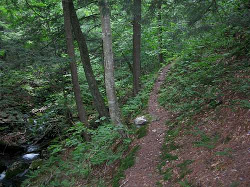 Pine Hill West Branch trail
The other way to approach Big Indian would be to take the Seager-Big Indian trail to the Pine Hill-West Branch trail north of Big Indian. The Seager-Big Indian trail is about 3 miles, and then it's over a mile to reach Big Indian off the Pine Hill-West Branch trail. The Seager-Big Indian trail doesn't provide views of the mountains either, but it has a more scenic view of the forest. There are some tricky water crossings, but you get some nice views of Catskill streams that make this worth the effort.
 Along the Seager-Big Indian trail
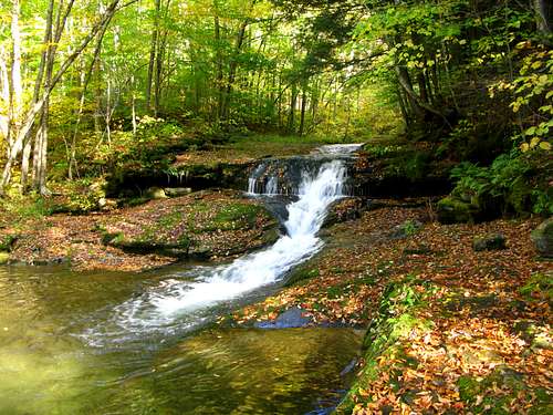 a favorite scene on the Seager-Big Indian trail
A hike to Big Indian can be combined with Eagle Mountain, which is north on the Pine Hill-West Branch trail, so why not get two for the price of one if you have the time. It's also done with Fir Mountain which is a real bushwhack with no trail or herd path, so you have to do your research for that one. However you decide to hike Big Indian you won't have to deal with crowds of people, and you'll have a nice time hiking through the forest.
Getting There
To reach the souhtern terminus for the Pine Hill-West Branch trail, you need to travel on CR 47 which can also be called Slide Mountain Road or West Branch Road. CR 47 can be reached from NY 28 in the town of Big Indian about 30 miles from Exit 19 off I-87 in Kingston.To reach the Seager-Big Indian trailhead you need to drive on Dry Brook Valley Road (CR 49) until it's end. CR 49 is off NY 28 in Arkville further down the road from the town of Big Indian, which is again about 30 miles from Exit 19 off I-87 in Kingston.
Red Tape
There's really no red tape to deal with. There's no fee for parking at the Seager-Big Indian trailhead or the Pine Hill-West Branch trailhead. If you're camping just follow the simple rules for camping in the Catskills.Camping
In general it's legal to camp under 3500 feet in NY as long as you are 150 feet away from the trail. You can camp over 3500 feet in the winter, from December 21st until March 21st. There are lean-tos on the Seager-Big Indian trail and the Pine Hill-West Branch trail. The Shandaken Creek lean-to is located about 2 miles up the Seager-Big Indian trail. The Biscuit Brook lean-to is located about 2 miles up the Pine Hill-West Branch trail's southern terminus.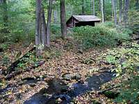 Shandaken Creek
External Links
For weather info I usually head to NOAA or Weather Underground.I've found this guidebook to always be useful on any Catskill hike.
A couple of websites that I check out for Catskill info are the Catskill-3500 Club and Catskill Hiker.
If you're looking to join a mountain club that goes to the Catskills, two good ones are the Appalachian Mountain Club and the Adirondack Mountain Club.
For peakbagging information why not go to Peakbagger.
