
-
 6249 Hits
-
 82.48% Score
-
 15 Votes
|
|
Mountain/Rock |
|---|---|
|
|
38.91795°N / 110.37174°W |
|
|
Scrambling |
|
|
Spring, Fall, Winter |
|
|
4500 ft / 1372 m |
|
|

Overview and Climbing Information
The unofficially named Buckmaster Hills are at the eastern edge of the San Rafael Swell, just before I-70 makes its climbed into the dramatically broken landscape of the San Rafael Reef via Spotted Wolf Canyon.
Everyone driving on UT 24 between I-70 and Hanksville sees these badlands buttes. A few probably stop to photograph them. I’ll bet just about none of them get out to climb or explore in the area. While the buttes are not likely to appeal as a primary destination, they make a nice stop along the way to it and are very easy to access.
One reason is probably the barbed-wire fence between the road and the buttes, suggesting the Buckmaster Hills are on private property. But I have studied area maps, and the buttes seem to be on BLM land, meaning it is public land. Also, there is a ladder over the fence at the northern end and a gate near the southern end; that and the absence of “No Trespassing” signs, which Western landowners do not hesitate to post, bolster the notion that the Buckmaster Hills are on public land.
The hills run for about three miles north to south from the junction of 70 and 24, though they are more concentrated in the northern two miles. While the complex is not a single mountain, it is too small to be called an area for SP purposes, and that is why the Buckmaster Hills are presented as a mountain page.
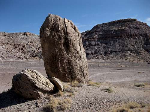
The highest of the hills only rise 200-300’ from their bases, and views aren’t much different than they are from roads in the vicinity, but prominence and views are not always the selling points for those who love badlands; what appeals to such people are the shapes, rocks, colors, and solitude found therein.
I have climbed two of the buttes here-- both are at the northern end of the complex-- and found Class 3 conditions on each. Though not technically difficult, this is not your standard Class 3, for the footing is bad (you are basically climbing up dry mud) and no handhold can be trusted. Expect to slip frequently, and expect holds to break off. Climbing up gullies is generally better because the footing is better (harder surface, and more rocks) and your footprints will be erased more quickly courtesy of storms. Avoid climbing here in wet conditions; the peaks will be a gumbo almost akin to quicksand.

Getting There
Leave I-70 at Exit 149, about 11 miles west of Green River. Turn south onto Utah 24. If you go north, you will be on a dirt road following Buckmaster Draw into a rocky landscape.
The hills are plainly visible from the interstate and are on the east side of 24. There is a large parking area on the west side of the road less than a mile from the interchange; there is otherwise not much room to pull off the road without either driving over vegetation of being off-camber.
As mentioned in the section above, there is a ladder over the fence just south of the interchange. But if you want, it is also easy to slide under the fence since the barbs are not on the lower wires of the fence.
Red Tape
None unless I am badly mistaken and this is private property.
Camping
None
