
-
 52385 Hits
-
 91.08% Score
-
 34 Votes
|
|
Mountain/Rock |
|---|---|
|
|
47.42939°N / 11.04821°E |
|
|
Hiking, Mountaineering, Scrambling, Via Ferrata, Skiing |
|
|
Spring, Summer, Fall, Winter |
|
|
8622 ft / 2628 m |
|
|
Overview
 Winter view
 Alpspitze
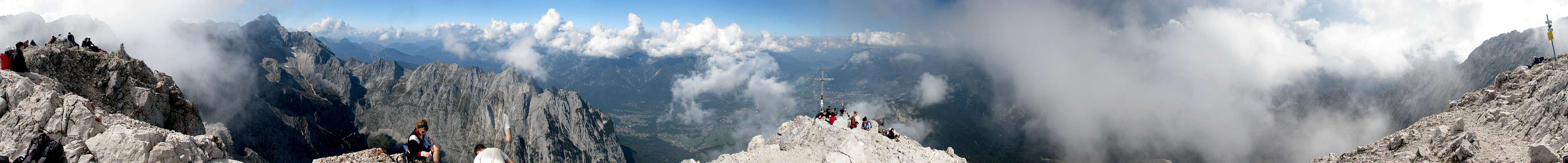
The summit offers a breath taking view of Garmisch-Partenkirchen with the classic summit shot showing the summit cross above Garmisch-Partenkirchen. Additionally you have a splending view of the Höllental from far above. Furthermore the view to the north is amazing. On bright days you may even see Munich with Frauenkirche and Olympiaturm and cities beyond.
The first ascend was propably done via the east slope by J. Burger in 1825. The summit cross of Alpspitze was installed in 1946 by Richard Weber, Kaspar Jocher and the Kopling family.
Tourism
| In 1970 the construction of Alpspitzbahn cable car started and was finished in 1973. Together with the Hausbergbahn and Kreuzeckbahn cable cars they create a nice ski area in winter (see www.zugspitze.de for more information). There have been plans to build a cable car running up to the summit of Alpspitze but fortunately this was never done. Many people say that all the iron and cables which would have been required by the cable car where used to build the north face ferrata (because there is much iron which is simply not needed). Because of these cable cars there are always a lot of people up there. Most people go skiing in winter, hiking in summer and many ascend Alpspitze. So sharing the summit with 30 people is quite lonely. Because of the near top station of the cable car a lot of inexperienced people are around causing accidents and fatalities. In 2009 there where plans to construct a gigantic "flying fox" starting at Osterfelderkopf leading down to Kreuzeck (about 1800m long!). Additionally a huge viewing platform was constructed and opend on 4/July/2010 at Osterfelderkopf. Both projects raised a lot of protest and many people demonstrated against it. Climber Stefan Glowacz demonstrated against it by sitting on a portaledge hanging from the viewing platform (link to a german page with pictures). |  The famous "Eisenweg" The famous "Eisenweg" Alpspix viewing platform Alpspix viewing platform |
Panoramic Views
  |
 Alpspitze-Jubiläumsgrat-Zugspitze as seen from Garmisch-Partenkirchen
Routes Overview
Alpspitze offers various routes to get to the top. To give you an overview I' ll just list the most popular ones.- "Eisenweg" (North face ferrata)
Starting at Osterfelderkopf you have to follow ths signs to the base of the mighty north face of Alpsitze. From there an easy via-ferrata (grade B) leads 600m of altitude difference up to the summit. Don' t expect to be alone there on a sunny day. Additionally there are a lot of inexperienced people around... - Nordwandsteig
Also starting at Osterfelderkopf this route traverses the north face and joins the route coming from Schöngänge within the Oberkar. The traverse of the north face includes two tunnels (I don' t know if there is light or not so make sure to have a light with you...). - Mathaisenkar / South-west ridge
Starting at Hölltenatlangerhut a trail leads up the lonely Mathaisenkar. From there an easy via ferrata (grade B) leads up to Grießkar-Scharte where the south-west ridge leads on to the summit. - Schöngänge / East slope
Starting at Osterfelderkopf you have to descend about 100m, or better ascend from Kreuzeckhaus directly via Hochalm. Follow the signs towards Schöngänge - a secured easy via ferrata through a about 100m high face. From the top of the face a trail leads up the east slope of Alpspitze and up to the summit. - Rinderweg
The second option starting at Höllentalangerhut. This hiking trail leads up to Höllentor (2150m) close to Osterfelderkopf. From there you have all options starting at Osterfelderkopf to continue the ascend. - Jubiläums ridge
The famous Jubiläums ridge connects Alpspitze with Zugspitze. Mainly the route follows the south-west ridge to/from Grießkar-Scharte. For more information see the Jubiläumsgrat page.
 |  |  |  |  |
 |  |  |  |  |
When To Climb
| Alpspitze is always busy ;-) During the winter months most people ascend Alpsitze with skies along the east slope. See the beautiful Alpspitze - Main ski routes page created by selinunte01 for more information. Additionally the Jubiläumsgrat route is a demanding route which is done in winter as well. The north face ferrata is also possible if there isn' t too much snow. In summer, Alpspitze is summited very frequently by a lot of people. Don' t expect to be alone here and expect long delays on the ferrata routes. Additionally lots of inexpirienced people ascend Alpspitze along the more difficult routes since the cable car almost runs to the base of the north face. If you want to be quite alone on Alpspitze your chance is in late autumn when the cable car is closed. |  Lots of people Lots of people |
Getting There
 View from the train station
By Car
You reach Garmisch-Partenkirchen by car via three major access routes. Once in Garmisch-Partenkirchen you have to follow the signs to the Kreuzeckbahn with its parking lot. I guess the parking lot is free of charge but I don' t know.- From north (Munich)
You have to follow A95 to the south. At the end of the highway at Eschenlohe (where usually is a little traffic jam if you' re too late) simply go on driving along road B2 until reaching Garmisch-Partenkirchen a few minutes later. Follow the right lane to Ehrwald after the tunnel to get to Kreuzeckbahn. - From south east (Innsbruck, Italy)
From Innsbruck (also from Italy via Brenner pass) you have to follow the Inntal highway to the exit called Zirl. From there road 177 leads along the town of Seefeld in Tirol to the border of Austria/Germany. The road is renamed to B2 and leads on to Garmisch-Partenkirchen. On the first big traffic light you have to turn left to get towards Ehrwald and to Kreuzeckbahn. - From west
Starting at Ehrwald road 187 leads to the border of Austria and Germany. From there road B23 leads on to Garmisch-Partenkirchen. Shortly after passing the town sign you have to turn right to Kreuzeckbahn.
By Public Transportation
Garmisch-Partenkirchen has a good train connection to Munich (one train every hour). From Munich you have train connections to almost everywhere. Every two hours a train leaves/arrives from/to Innsbruck which provides train connections to Switzerland and Italy. Additionally the Außerfernbahn connects Garmisch-Partenkirchen with Reutte in Tirol.For more information visit Deutsche Bahn or ÖBB.
To get to the base of the mountain you have to leave the train station (go the long way under the rails not to the station building). From there you have to turn right to get to the road. Turn left and follow until you reach the open field on the left side. A trail leads accross this field and to Kreuzeckbahn.
Accomodation
There are two huts near Alpspitze which are perfect for an overnight stay before climbing Alpspitze: Kreuzeckhaus and Höllentalangerhütte. Additionally there are several places to stay at Garmisch-Partenkirchen (see www.gapa.de (english) for more information).Kreuzeckhaus
Kreuzeckhaus (1651m) is located north-east of Alpspitze at the summit station of the Kreuzeck cable car. To get to the base of Alpspitze you have to follow one of the trails to Osterfelderkopf (2030m). From there you can ascend via the north face ferrata, Nordwandsteig or Schöngänge (with some meters to descend). Another option is to bypass Osterfelderkopf via Hochalm (1704m) and ascend to Schöngänge directly which saves you about 200m in height.Höllentalangerhütte
Höllentalangerhütte is placed in the Höllental valley at 1387m and offers a less frequent climbed route along the Mathaisenkar. This route leads up to Grießkar-Scharte (2463m) and further up to the summit. Additionally the so-called Rinderweg leads up to Osterfelderkopf from where you have to same ascend options as from Kreuzeckhaus. You reach Höllentalangerhütte from Hammersbach (stop of the train up to Zugspitze starting at the train station of Garmisch-Partenkirchen) via the Höllentalklamm.Red Tape
There are no permits, fees or seasonal closures. The mountain isn' t part of any nature reservation area.Parking at the cable car is free I guess but I' m not sure (tell me if you know).
If you plan to use the cable car (Kreuzeckbahn or Alpspitzbahn) check out www.zugspitze.de for schedules and prices.
Maps & Books
|  Summit cross Summit cross |
Mountain Conditions
Weather conditions
WebcamsThere are several webcams around Garmisch-Partenkirchen showing Alpspitze.
|  Storm! Storm! |
External Links
- www.dav-huettensuche.de/index.php?huetten_id=222630&pagedef=details
Information about the Kreuzeckhaus hut near Alpspitze. - http://www.alpenverein-muenchen-oberland.de/huetten__wege/bewirtschaftete_huetten/uebersicht/hoellentalangerhuette
Homepage of the Höllentalangerhut. - www.gapa.de/en/_startseite/index.html?ydpb-id=wdac7629e24d5d80b90bd52cabe12bcbcda8624a4fc
Multilangual homepage of Garmisch-Partenkirchen with information about activities and places to stay. - www.zugspitze.de
Information about the ski area and all cable cars up to Alpspitze and Zugspitze