
|
|
Mountain/Rock |
|---|---|
|
|
40.46300°N / 111.8531°W |
|
|
Utah |
|
|
Hiking |
|
|
Spring, Summer, Fall, Winter |
|
|
6682 ft / 2037 m |
|
|
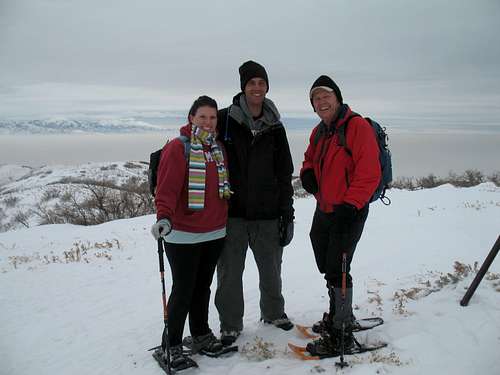
January 2011 snowshoe
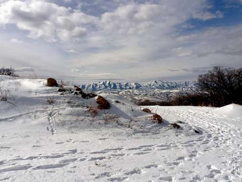
Jan 2012 view
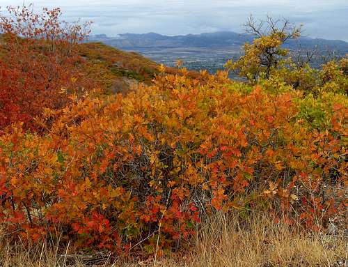
Fall colors
Overview
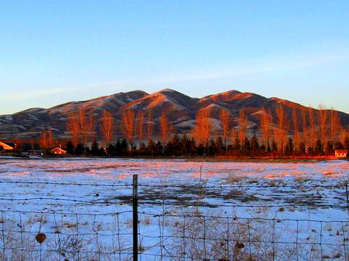
Early morning glow
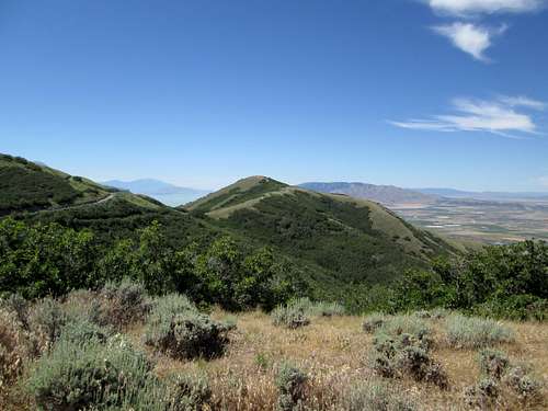
View Benchmark is exactly what its name indicated, a place with a view. It is really an unknown spot to most of those who live in the valleys below and that is easily understood. It is "dominated" by the more majestic Wasatch peaks that are just to the east and isn't much of an attraction when you consider all the competition from what is around it. Yet, from the summit area of View BM, there are wonderful views to be had for both the Utah and Salt Lake valleys as well as outstanding views over to Lone Peak, Box Elder Peak and the Mt. Timpanogos Massif. To the west are views to the Oquirrh mountain range. All of this within a hop skip and a jump of the major urban areas that are nearby. What is nice about this peak is the ease of access. Located close to Salt Lake City and the Alpine/Lehi area, it has great access thanks to the housing developments that have crept up onto the Suncrest area so that streets that are paved and maintained in wintry conditions are able to get you to within a mile or two of the summit.
It is an easy hike, with routes that are one and a half to two miles in distance and an elevation gain of less than 600 feet. This one makes a good tune up hike for conditioning when getting back into shape or when trying out snowshoes or even the good ole skiis that have been tucked away in the garage for awhile. Of course you have to have snow for those latter two activities but that is where View Benchmark shines, it is good for a quick one when you don't have the time for something more extensive.
Located on top is one of the interesting triangulation stations that once provided surveyors with landmarks for surveying purposes. See more of these interesting structures at this SP album. This one is the highpoint for the Traverse Mountain range, an east-west oriented little range that is most famous for the "Point of the Mountain" portion of I-15, which cuts through the Traverse range.
View Benchmark has 832 feet of prominence and more information can be found
HERE. A nice resource with some pics and a map can be found on SP member Eric Willhite's site HERE.
 End of the road End of the road |  Past the chain Past the chain |
Getting There
Head up from Draper on the Salt Lake side via Traverse Ridge Road to Suncrest and at the top turn right onto Deer Creek Road. Follow Ridge road one mile and you can either park near the end of the road (chain) or park in a small parking area that is just off of Deer Ridge Road on Elk Glen Drive. (15170 S Elk Glen Drive - 1455 E) This is actually a trailhead (Maple Hollow Trailhead Park) for the hiking/biking trails and has a couple of benches and picnic tables. No restroom facilities. See more on the Draper City website. This website also has maps and more information that you will find useful.From Utah valley via I-15, take the Highland/Alpine exit and head towards American Fork Canyon (signs to Timpanogos Cave indicate the right direction). Watch for the Smith's market on the right and turn left onto Highland Drive at the stoplight. Highland Drive heads up the hill and becomes Suncrest Drive. Follow it to the junction with Traverse Ridge road but continue across the intersection and you'll be on Deer Ridge road. Continue as noted above.
 Switchback Switchback |  No dumping sign No dumping sign |  Above switchback Above switchback |
The hike
From where you park, go past the chain, past a doggie bag dispenser set up, and up the road to where a lesser road makes a sharp switchback up the hill (about a half mile from the chain). If you take this switchback, you will shave about 1/3rd of a mile off of your effort. If you are looking for a longer hike, then stay on the main road and follow it as it descends slight beyond the switchback and then goes up the hill to the south and then curves back slightly to hook in with the other road. It is a mile from that switchback to the summit via this road and about 2/3rds of a mile if you take the switchback. It makes a nice loop to go up the switchback and then down the regular road. A rougher track, ATV in nature goes up to the summit from the main road and so basically there is a road to hike the entire way. That is why when it snows, the road is covered and it makes it a more interesting hike.I've hiked this little mountain in all seasons of the year and always enjoy the great views I get from the summit. I think you'll enjoy it too if you are looking for a quick hike in the local area.
 Winter snowshoe paradise Winter snowshoe paradise |  Snowshoe view Snowshoe view |
 Winter view of SLC
Roundtrip: 3 miles or 2.5 miles, depending on which way you hike up. Elevation gain is under 600 feet.
Sept 2015: I've recently found another way to make it a bit more challenging, and that is by starting at the Maple Hollow housing area on the southeast side of the mountain. It gains 1000 feet to the top, most of it cross country. I'll add a hike description soon but it makes it a good way to do a loop as well. I hike to the top, gain the old jeep track and follow it back to the original trailhead and then drop down a bike/hiking path that leads back down to Maple Hollow where I started.
Others use this for running and mountain biking but I like this offering: LINK Check out the video that is attached to the page.
Views
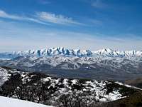 West to Oquirrh range West to Oquirrh range |  East to Box Elder East to Box Elder |  South to Utah Lake South to Utah Lake |
Red Tape & Camping
The future is bright for the View Benchmark area as at one point a developer owned much of the land and therefore there is a well maintained gravel road with sewer and water put in nearly up to the top of the peak itself. However, in a recent purchase the city of Draper has acquired the land and promised to not develop anything other than trails on it. Draper has done a great job of developing trails and keeping their word so it is probable that things will get better despite the fact that the existing jeep roads and such are unattractive to me but just wait for that winter coat of snow to make the mountain roads and paths more worthwhile.There are not any 'no trespassing' signs at the end of Deer Creek Road. Just step over or around the chain that blocks the end of the road and make your way towards View Benchmark, which is visible most of the way. One sign that does say 'no trespassing' is found about 1/2 mile up the road and it appears the intent of the sign is to keep people from dumping stuff. You can avoid that sign by taking a switchback that is just before it and using that way to access the peak.
There is no camping on the mountain or nearby. This is really just a simple hike that will only require a couple hours at the most. The local towns have plenty of motels and a KOA is available in Provo.
Weather


Nearby hike to Steep Mountain
For many people, the hike up to View BM and back won't satisfy their overall conditioning needs. You can add a side trip to Steep Mountain which will add an additional three miles to your day and another 700' or more of elevation gain. I will add information on this side trip in the very near future as I am now working on adding the pictures and a map. I might add it makes a great snowshoe hike as there is no avalanche danger in that area and will give you a great workout as well as great views of the Salt Lake area with Draper right below you and mountains on both sides of you. See my album for Steep Mountain (LINK)Recently, a page for Steep Mountain has been added which describes how to access it from the Draper side. Link
Hiking the nearby "bumps"
Just hiking to the top of View Benchmark and back isn't much of a hike unless you are using snowshoes but the rest of the year, I like to add a bunch of "bumps" to the overall effort.
Adding bump 6562 is a good way to extend the hike and get more of a workout and I often do it like this:
I hike up the road from the trailhead to the top of bump 6562, a distance of 1.6 miles. Then I head back and include another bump 6476. Now sometimes I continue on from here to Steep Mountain if I have the time but if not, I reverse back and find a cross country way to the top of a bump which is about 6550' in elevation. From there I drop down a bit and then hike up to the top of View Benchmark. From there, I can either hike back to my vehicle or add a couple of other unranked bumps to the effort. I think you get the idea, you can make this area work for your conditioning by extending the hike to other spots and the mileage and elevation gain will add up to whatever you'd like it to be. Can it get boring? Yes but sometimes you just have to appreciate what you have literally in your back yard.
The Triangulation Structure & The Mystery of....
the missing panels.Early in 2009, I made two visits to the top of View BM and during the Feb visit, the triangulation structure had all the orange panels to place but one, which was on the eastern side of the hill about thirty feet from the structure.
Then I came back a few weeks later, in April, and all the panels were gone.
No one that I've talked to has a good explanation for why they were removed butfor me, I miss those garish orange panels. Oh well....
 Triangulation structure Triangulation structure |  Triangulation - panels are gone Triangulation - panels are gone |  When it had the panels When it had the panels |
For more information on this interesting landmark that adorns the top of View Benchmark, check out my album on Utah's Triangulation Structures HERE.
Where is the Benchmark?
The standard USGS benchmark is not to be found on View Benchmark. I suspect that it is under the concrete pad that the triangulation structure was built on.