
-
 4590 Hits
-
 83.01% Score
-
 16 Votes
|
|
Mountain/Rock |
|---|---|
|
|
44.81890°N / 107.8053°W |
|
|
Sheridan |
|
|
Hiking |
|
|
9420 ft / 2871 m |
|
|
Overview
 The slopes of Rooster Hill
As far as mountains go, Rooster Hill would probably rank very high on the list of unassuming peak names. This name does not inspire visions of a grand and epic climb, and I can assure you that the process of reaching the top of this mountain is anything but grand or epic. Of the numerous grassy peaks in the northern Big Horns of Wyoming, Rooster Hill is perhaps the easiest one to summit, requiring an easy stroll from the nearest road.
So why visit this peak? While its prominence of 320 feet does not make it a spectacular mountain, the small forested areas and the fields of thick wildflowers on its slopes make this a very pretty hike for anyone passing through on the Medicine Wheel Scenic Byway who wants to get out of the car for a half hour or so. Summit views include a nice look at Bald Mountain to the south, and Burnt Mountain can be seen off to the north; the vast forests that blanket large portions of this area stretch for many miles away to the north and east. Duncum and Medicine Mountains are the prominent peaks seen looking west from the summit.
Getting There and Climbing Information
 Route around the forest
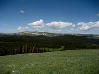 Summit view to Duncum Mountain
From Lovell, Wyoming, take U.S. Highway 14A heading east for about 25.5 miles and turn left on Road 14, which is marked for Devils Canyon. To approach from Sheridan, Wyoming, follow Highway 14 to Burgess Junction, turn right on Highway 14A, and travel for about 18.5 miles. Drive on this road for a little ways and turn right at signs directing you to Burnt Mountain. Follow this road until you see the first section of forested area off to the right. Walk around to the right of the trees and up the slopes to the top; there is one small rocky band that pokes through the grass, but it is easy walking all of the way.
The round trip distance to the top of Rooster Hill is just less than one mile with 400 feet of elevation gain.
 A sea of green, blue, and white
Red Tape and Camping
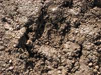 Bear Track
There are no fees to use this area. Access to this mountain is very easy except during the winter and spring, when Highway 14A is closed. The Big Horns are home to an abundance of wildlife, so be especially aware of moose, elk, black bears, and mountain lions when hiking in this area. There are no grizzlies in the Big Horns.
Places to camp in the Big Horns are numerous, with the majority of the range being open to dispersed camping. Camping is not allowed within 100 feet of lakes or streams, or within 1/4 mile of major roads. For complete rules and regulations, visit: http://www.fs.fed.us/r2/bighorn/recreation/camping/