
-
 6936 Hits
-
 84.27% Score
-
 18 Votes
|
|
Mountain/Rock |
|---|---|
|
|
44.46020°N / 109.3323°W |
|
|
Park |
|
|
Hiking, Scrambling |
|
|
Spring, Summer, Fall, Winter |
|
|
7811 ft / 2381 m |
|
|
Overview
 NW Sheep Mountain
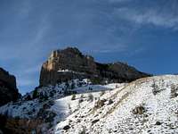
Sheep Mountain is the large fortress of a mountain that overlooks Buffalo Bill Reservoir from the west near Cody, Wyoming. Encompassing a space of nearly ten square miles, it is the last peak that sits between the North and South Forks of the Shoshone River before they join at the reservoir. While hiking on this mountain, you will enjoy a wide array of scenery ranging from narrow canyons and forested areas to wide meadows and spectacular rock pinnacles.
There are currently two other pages on SummitPost dealing with some of the summits on this large mountain; the highest point is covered on this page, and the large butte directly above the trail head is found on this page. While the butte on the latter page is an unranked peak, there are two other ranked peaks that are part of Sheep Mountain, located on the southwest and northwest corners of the mountain. NW Sheep Mountain is just 81 feet lower than the highest summit, and the views from its summit are far superior due to the fact that there are no trees that interfere with the panorama.
The tops of the three spectacular rock outcrops of NW Sheep Mountain are 1200 feet above the valley drainage that runs through the center of Sheep Mountain. All three can be climbed via a grass ridge followed by some easy Class 3 scrambling; the rock is good and some more difficult (and possibly technical) routes could be done on the steeper east faces. Summit views include large areas of all three parts of the Wyoming Absarokas and distant views of some of the Big Horn Basin.
 Approaching snowstorm
Getting There and Climbing Information
 Canyon walls from the trailhead
 The steep trail that leads through the canyon to the middle of Sheep Mountain
To get to the Sheep Mountain Trailhead, start from the traffic light at Wal-Mart in Cody and travel about 12.7 miles. This will take you through Shoshone Canyon and past Buffalo Bill Reservoir. There are signs marking the Sheep Mountain Day Use Area; turn left here and drive for 0.5 miles, turn left onto Stagecoach Trail, and drive for another mile. You will see a small sign on the right that reads "Sheep Mtn. Pit" across from the South Shore turnoff. Turn right at the gravel and dirt pit and drive up the road for 0.35 miles before parking at the sign at the trailhead. This road not taken care of and is a very rough drive in a high clearance 4WD.
Follow the two-lane track for a very short distance until a single trail splits off to the right. Take this trail, which will take you to the right of the butte that you will see in the center of the view looking towards Sheep Mountain. You will travel on a steep trail through a small, beautiful canyon with a spectacular rock face on the right of the valley that stretches up over 600 vertical feet. Once out of the canyon, the scenery changes from thick forest and rugged rocks to gentle meadows and wide open spaces.
 Gully below the summit ridge
 Rock outcrops
After passing the first drainage to your right, look for one of the game trails that ascends the spur that drops down right next to the trail. Once on top of the hill, the tri-peaked mountain comes into view for the first time; stay on top of the ridge to reach the gully that is located between the highest summit on the right and the center rock outcrop. After scrambling to the top of the gully, turn right and climb up the step-like rocks to the top. There is some nice exposure off of the north and east sides of the summit area overlooking the North Fork Valley and some other rock pillars.
 View from just below the summit
To make a fun loop, return down the ridge and ascend the other two rock outcrops, both of which are easy scrambles. Return by descending the gully between the lower two summits and traverse back across to the left to rejoin the ridge that you ascended. A round trip of this loop from the trail head is just over 5.0 miles with about 2300 feet of elevation gain.
 The middle rock outcrop
Red Tape and Camping
The are no fees required to hike the Sheep Mountain Trail; however, the nearby fishing, picnic, and camping areas in Buffalo Bill State Park require a day use fee.This mountain is teeming with wildlife; both black and grizzly bears roam this area, and mountain lions, wolves, elk, deer, and a large array of birds can found here as well, so bring your bear spray and stay alert.
The closest campground is the North Fork Campground and the North Shore Bay Campground is located a little closer to Cody; the two have a total of about 100 spaces.
 Always a concern...
External Links
Information on Buffalo Bill State Park:http://wyoparks.state.wy.us/Site/SiteInfo.asp?siteID=3
http://www.wyomingtourism.org/cms/d/buffalo_bill_state_park.php
Information on Land Ownership on Sheep Mountain:
http://www.nature.org/wherewework/northamerica/states/wyoming/press/press2740.html