
-
 7708 Hits
-
 88.61% Score
-
 27 Votes
|
|
Area/Range |
|---|---|
|
|
46.70277°N / 10.80176°E |
|
|
Hiking, Mountaineering, Scrambling, Skiing |
|
|
Spring, Summer, Fall, Winter |
|
|
11339 ft / 3456 m |
|
|
1 - Overview
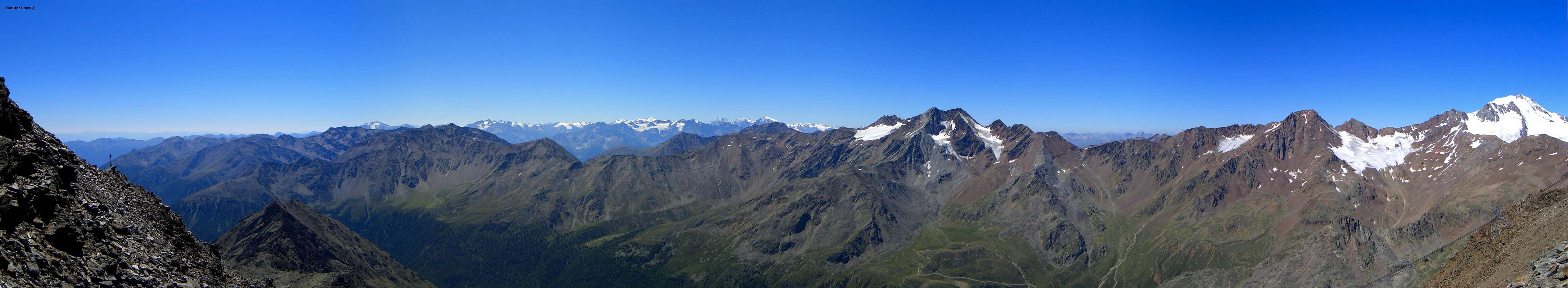
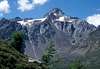
 Saldurkamm seen from Matscher Tal Saldurkamm seen from Matscher Tal |
If you talk of the Ötztal Alps you usually have an Austrian mountain range in mind with glaciated peaks, lots of hiking and skiing possibilities, deep valleys and high mountains. On second thought you'll realize that the main ridge of this important range makes up the border between Austria and Italy between Reschenpass / Passo Resia and Timmelsjoch / Passo del Rombo. And finally you'll find three of the subgroups completely on Italian ground: Planeiler Berge, Saldurkamm and Texel Group / Gruppo di Tessa. All three are different in character from their northern counterparts but also very different from each other. This page deals with the southernmost of the three: Saldurkamm.
I am not sure whether there is an Italian name for the subgroup, it would be something like Cresta Saldura, leaving the impression that the group consists of a single ridge. It doesn't. Rather it seperates in two main branches, a western one between Matscher Tal / Val di Mazia and Schlandrauntal / Val di Silandro and an eastern one between the latter and Schnalstal / Val di Senales. To the north the group is connected to the Weißkamm Ridge with Steinschlagferner, a glacier between Innere Quellspitze and Äußere Quellspitze serving as separator. The group has been named after Saldurspitze / Punta Saldura, the highest mountain in the central part of the group.
2 - Saldurkamm on SP
  |
3 - The Summits
 |
The following listing follows the Alpenvereinsführer (German Alpine Club guidebook , see list of books below), which counts Innere Quellspitze to the Weißkamm Ridke, while counting its counterpart, Äußere Quellspitze already to Saldurkamm.
- Äußere Quellspitze / Cima di Sorgente di Fuori (3385m)
- Schwemser Spitze / Punta d'Oberettes (3456m)
![]()
- Saldurspitze / Punta Saldura(3433m)
![]()
- Lazaunspitze / Cima di Lazaun (Also Lagaunspitze, 3439m)
![]()
- Oberer Saldurkopf / Monte Saldura (3421m)
![]()
- Innere Saldurspitze / Punta Saldura di Dentro(3189m)
- Kortscher Schafberg / Monte delle Pecore (3103m)
![]()
3.2 - Mastaun Group
- Berglerspitze / Punta del Monte (3019m)
- Gerstgraser Spitzen / Punti di Cortiserrade
- Western Gerstgraser Spitze (3100m)
- Eastern Gerstgraser Spitze (3089m)
- Mastaunspitze (3200m)
- Malander / Malandro (3173m)
3.3 - Vermoi Group
![Malander (3174m), Wiegenspitze (3109m), Zerminger Spitze (3109m)]() Malander (3174m), Wiegenspitze (3109m), Zerminger Spitze (3109m)
Malander (3174m), Wiegenspitze (3109m), Zerminger Spitze (3109m) - Zerminger / Monte Zerming (3108m, 3059m)
![]()
- Wiegenspitze / Cima Culla (3109m)
- Schwarze Wand / Croda Nera (2982m)
- Hohe Wiegenspitze / Cima Culla Grande (2978m)
- Kleine Wiegenspitze / Cima Culla Piccola (2743m)
- Rosskopf / Monte Cavallo (2891m)
- Graue Wand / Croda Grigia (2772m)
- Vermoispitze / Punta Vermoi (2921m)
![]()
- Grubenspitze / Punta delle Fosse (2899m)
- Trumser Spitze / Punta di Trumes / 2912m)
- Gamseck / Monte dei Camosci (2552m)
3.4 - Litzer Spitze / Hochalt Group
- Ramudelkopf / Cima Ramudla (3357m, 3314m)
![]()
- Rappenspitze / Punta Corvara (3187m)
![]()
- Upiakopf / Monte Upi (3174m)
- Hochalt / Monte Alto
- Southern Summit (3285m)
- Northern Summit (3265m)
![]()
- Weisse Riepl / Costa Bianca (2950m)
- Litzer Spitze / Punta d'Alliz (3205m)
![]()
- Remsspitze / Punta di Remes (3205m)
![]()
- Madratschknott (3081m)
- Hohes Kreuzjoch / Monte Croce (3054m, 2986m)
- Schwarzer Knott / Rocca Nera (2807m)
- Köpfelplatte / La Lasta (2410m)
![]()
3.1 - Main Ridge
 Lazaunspitze (3218m, 3313m), Saldurspitze (3433m), Lagaunspitze (3439m)


4 - Getting There
 |
Main access to the group is from three sides: Vinschgau / Val Venosta in the south, Schnalstal / Val Senales in the north and Matscher Tal / Val di Mazia in the east. The latter two valleys can be reached from different points in Vinschgau / Val Venosta.
From Austria
- Take B180 from Landeck, which at the border turns into SS40 / SS38.
- Follow the road through Vinschgau / Val Venosta and both Schnalstal / Val Senales and Matscher Tal / Val di Mazia turn off to the north from it.
From Italy
- Take SS38 from Bozen / Bolzano passing Meran / Merano into Vinschgau / Val Venosta
From Switzerland
- Take B28 across Ofenpass / Pass dal Fuorn and through Münstertal / Val Müstair.
- At the border it turns into SS41 to Glurns / Glorenza.
- There turn onto SS38 east into Vinschgau / Val Venosta.
5 - Accommodation
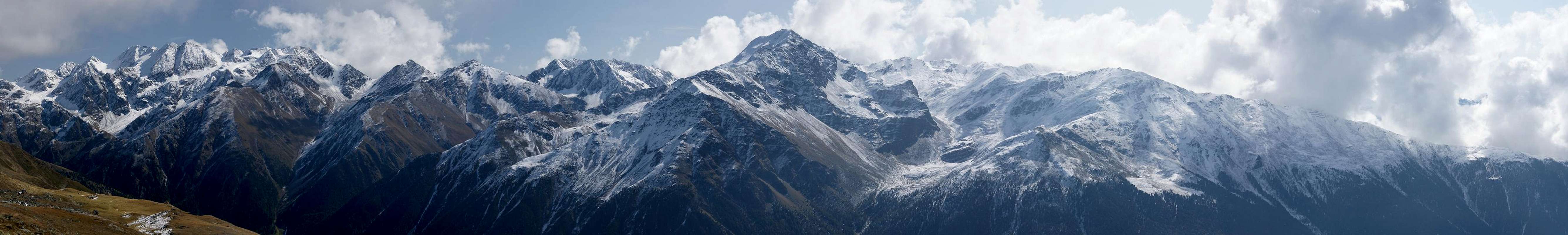
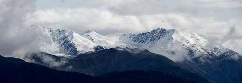
 Saldurkamm above Matscher Tal
- Vinschgau / Val Venosta Accommodation
- Schnalstal / Val Senales Accommodation
- Reschenpass / Passo di Resia Accommodation
6 - Red Tape
There is no red tape I'm aware of.7 - Weather Conditions
8 - Maps and Books
Maps
- Vinschgau / Val Venosta
Kompass Map WK52
1:50000
ISBN: 978-3-85491-058-9
- Alta Val Venosta / Vinschgauer Oberland
Tabacco Map 43
1:25000
Books
- Ötztaler Alpen
W. Klier
Alpenvereinsführer
Rother Verlag
ISBN: 3-7633-1123-8
- Vinschgau
Rother Wanderführer
Rother Verlag
ISBN: 978-3-7633-4204-1
- Vinschgau / Ortlergruppe
Kompass Wanderbuch 950
Kompass Verlag
ISBN: 3-87051-404-3