
-
 9369 Hits
-
 77.47% Score
-
 8 Votes
|
|
Route |
|---|---|
|
|
35.19843°N / 106.45658°W |
|
|
Trad Climbing |
|
|
Spring, Summer, Fall, Winter |
|
|
Most of a day |
|
|
5.6 (YDS) |
|
|
5 |
|
|
III |
|
|
Overview
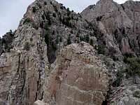 The Complex
Getting There
To do the route in "correct" fashion, a start at the Elena Gallegos Picnic Area is warranted. After taking Tramway north from I-40 beyond Academy Road and turn onto the road to the picnic area. Park in the northeast corner where a large map awaits your inspection.
Route Description
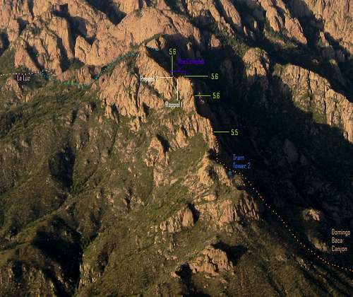 Aerial View of Whiskey Ridge
From the Elena Gallegos Picnic Area, travel north along the network of trails to reach the Domingo Baca Trail (230). Follow the trail far into the canyon staying as close to the stream as possible. At some point, you'll hit a waterfall/granite cliff blocking the path. Work your way up and right onto the broad ridge and skirt its northwestern edge until you can return back to the stream. About 10 minutes beyond the Great Granite Gates (prominent rock cliffs/buttresses rising from the creek floor), veer left (west-northwest). If in doubt, use the tram cables for guidance.
This section is where it gets hairy. Prepare yourself for yucca with sharp, three-foot long leaves, cactus patches 20-30 feet in diameter, unforgiving brush oak, hordes of boulders, and very few paths through it all. Some game trails do exist and may provide routes of least resistance but beware, deer can jump bushes you can't, leaving you with a dead end to contend with. Despite horrible route-finding difficulties and aimless off-route jaunts, the trip to the tower took roughly 3 hours, which I believe to be a good estimate.
Ridge Proper:
4th Class
Short Pitch 1: 5.5 (nice, huge, wobbly boulder makes for fun stemming)
Long Pitch 2: 5.1
4th Class
Short Pitch 3: 5.6
4th Class
Long Pitch 3: 5.6 and 5.4 downclimb
Rappel 1 (airy)
4th Class
Rappel 2
Short Pitch 4: 5.6 and 5.5 downclimb (loose rock)
3rd/4th Class
Keep in mind that all anchors are self-made. The first rappel station has two pieces of webbing and one cord wrapped around a massive, sturdy boulder. The second rappel stations has three pieces of webbing around a foot-wide tree.
Descent:
Option 1a Via La Luz (Recommended):
3rd Class descent along ridge to the southern base of the Thumb
Bushwhack north around northwest ridge of the Thumb to upper portion of La Luz.
Option 1b Via Domingo Baca:
3rd Class descent along ridge to the southern base of the Thumb
Bushwhack south into Domingo Baca and regain trail back to Elena Gallegos
Option 2: Double-back down route to Domingo Baca and Elena Gallegos

The following trip report has a more detailed description of the route:
Hangover on Whiskey Ridge