
|
|
Mountain/Rock |
|---|---|
|
|
42.76441°N / 0.36633°E |
|
|
Hiking, Mountaineering, Mixed, Scrambling, Skiing |
|
|
Spring, Summer, Fall, Winter |
|
|
8750 ft / 2667 m |
|
|
Overview
 Sarrouyès from Saint-Lary
 Sarrouyès from the West
 Sarrouyès from Saint-Lary
 Sarrouyès from Estos
 Sarrouyès from Ourtigué
Pic de Sarrouyès is a relatively small but very beautiful observatory located in the Lustou group, that separates the valley of Aure and the valley of Louron. It is the close neighbour of the Pic d'Estos, and is particularly well visible from the bottom of the Aure valley, as well as from all the road leading to the the Azet pass.
It is a top for walkers, quite easy to climb by its normal route, despite the path on the final part may require a little scrambling. Snow can complicate it in the end.
The summit panorama is very rewarding, we get superb views to many neighbours such as the Lustou and its northern ridge, called Pararouis, on its nearest neighbour Estos of course, which looks splendid all the way long, overlooking the little lakes "Lacs des Miares" (the ascent of this other peak can be combined with Sarrouyès in the same day).
Looking East, we get a whole panorama to the high mountains of the Luchonnais, from the Hourgade, the Perdiguère, the Gourgs Blancs. The Posets and the Bachimala South-East.
The name of this peak probably comes from "Mountain goat", in other words "Chamois", or more precisely "Isard" as they are called in the Pyrenees. In old Gasconian dialect this words derivates near the Spanish word "Sarrios" or "Sarrau", and many homonyms differently written according to dialects. No doubt the name means it's a place they like.
 Panorama to the Sarrouyès from the Azet road Panorama to the Sarrouyès from the Azet road |
Getting There
 Sarrouyès from the ourtigué road
 Sarrouyès from Pla d'Arsoué
 Sarrouyès from West
 Ourtigué barns
 Ourtigué barns
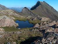 From Lacs des Miares
 Sarrouyès Valley
As we can expect from a peak located between two french valley in "cul-de-sac", the Sarrouyès is best reached from France by car.
Both of the possible starting points (Col d'Azet and Ourtigué) can be reached either from the Louron or Aure valley, however the drive via the Aure valley is simplier, especially for Ourtigué, despite the peak is more oriented on the side of the Louron valley.
The Aure valley is also the only possibility if you come from Spain (Huesca, Ainsa) and the Bielsa Tunnel.
View Larger Map
 Sarrouyès below
Red Tape
 Sarrouyès Valley
 Sarrouyès Valley
Pic de Sarrouyès is not located in any National park, however beware of not leaving rubbish and so on...
The Sarrouyès valley, which you will walk whatever is your starting point, is a common area for cattle breeding; beware of pig-headed cows... :)
beware also if parking the car at Col d'Azet, one might find scratches of horns on the car body...
On the final ridge of Sarrouyès, beware of the rock and not to slip, this is a very brittle type of schist.You can bivouac anywhere you want in the area, far from the road and villages, without any troubles.
 Sunset on the Sarrouyès
Routes
 Sarrouyès from Lacs des Miares
 Sarrouyès valley
 Sarrouyès valley at dawn
 Sarrouyès hut
 Sarrouyès lake
Two starting points are possible:
- From the Granges d'Ourtigué
- From the Col d'Azet
Both are nearly the same from the elevation point of view, as these two routes meet in the Sarrouyès valley.
Starting from Col d'Azet involves going down during a significant part of the approach (then going up when coming back).
Furthermore, the route via Col d'Azet goes under the pylons of the ski station, and col d'Azet is more remote to reach by car than Ourtigué.
Then, hikers may prefer the more picturesque route via the Ourtigué barns.
However, the first part in the Ourtigué forest doesnt'allow the views we get on the Azet route.
 Arriving at the Sarrouyès pass
 Sarrouyès from Ourtigué
 Sarrouyès summit
 Looking to Hourgade
 Sarrouyès summit cliffs
 Looking to Estos
 Looking to Lustou
The rest of the route goes (almost) until the twin lakes of Sarrouyès, located in a northen corrie that almost never sees the sun. Just before these lakes, the real path is climbing on the right, towards the Sarrouyès pass, just before which is located a green metallic hut of sherperds (closed).
One can give a visit to the little "Lacs des Miares", despite these little lakes are not exactly on the route. The reflections of the surrounding peaks in them, Estos, Sarrouyès, Parraouis, are gorgeous. This is the point from where the route to the Estos separates.
Then, the rest of the ascent consists into a very straight-forward walk on the steep ridge, to the top. This route can be slightly shortened by making the ascent taking the turn as sharp as possible around the peak, but going steeply onto the wild grass.
We usually meeet a lot of tourists in the end of this hike, and the lifts from the Azet station work now also in summer, taking tourists into the Sarrouyès valley. However very few of them get to those summits.
 Lacs des Miares and the Sarrouyès
Accomodation
 The old center of Vielle Aure
 Vignec in winter
 Vignec in summer
 Windows
 Windows
You can bivouac anywhere you want in the area, far from the road and villages, without any troubles.
Concerning official campsites, there are many in both the Aure and the Louron valley.
There are also many accomodations :
http://www.vallee-aure.com/
http://www.vallee-du-louron.com/
(go to the "hébergements" category, the Tourist Information of the Valley d'Aure didn't even mind to translate the site, which is a shame...)
One accommodation is worth mention for large groups of people: La Filature (former spinning mill), in Ancizan, with further information here and here (French). Prices can go as low as 10€ for groups over 10 people. A separate apartment is available too but rates may vary depending on the charges being shared with others or not.