
-
 14036 Hits
-
 90.13% Score
-
 31 Votes
|
|
Area/Range |
|---|---|
|
|
36.05830°N / 107.9589°W |
|
|
Hiking, Scrambling |
|
|
Spring, Summer, Fall, Winter |
|
|
6200 ft / 1890 m |
|
|
Overview
 Pueblo Bonito
Chaco Culture National Historical Park is a US National Historical Park hosting the densest and most exceptional concentrations of pueblos in the American Southwest. The park is located in northwestern New Mexico, between Albuquerque and Farmington, in a remote canyon cut by the Chaco Wash. The wash is usually dry. Seventy miles from the nearest town and accessible only by dirt roads, it is remote even by today's standards. Chaco is a high desert, sun-scorched in the summer and bitterly cold in the winter.
Chaco contains the most sweeping collection of ancient ruins north of Mexico and preserves one of the most important pre-Columbian cultural and historical areas. The setting is beautiful inside a shallow, ten-mile canyon, and if you get enough energy to climb the cliffs above the canyon, you get rewarded with amazing views onto the pueblos, kiwas and ruins below.
It is a designated UNESCO World Heritage Site.
Chaco Canyon National Historical Park
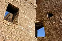 Nice masonry at Chaco Canyon
 Petroglyph of a Mountain Lion
Evidence of human presence in the area stretches back to as early as 2900 BC. These groups were largely nomadic, until around AD 200, when the first farmers settled in the area and built small pit houses.
Then in roughly AD 850, a great change took place. The people began building in a radically different manner, constructing massive stone buildings unlike any that had been built before. These structures soared to four or five stories and contained up to seven hundred rooms and dozens of kivas. Connected to one another by lines of sight that would have enabled rapid communication, these great houses were feats of engineering. Buildings were often aligned with celestial bodies, and they included water collection systems, and were linked to outlying communities by an extensive networks of roads. These elaborate buildings evidence a sophisticated and highly organized culture, with Chaco Canyon at its center.
Construction continued for three hundred years, until about AD 1150, when the area was abruptly abandoned. It's not completely clear why the people left Chaco Canyon, but prolonged drought is one possible explanation. It was around this time that communities in other places in the region, such as Mesa Verde, grew in size and importance. Most likely, the departing Chacoans migrated to surrounding areas.
Today, modern Pueblo people all trace their roots to Chaco Canyon, and consider it a sacred place.
In the late 1800s, it became clear that Chaco Canyon needed protection from looting and vandalism. Chaco Canyon National Monument was established in 1907. It became a national historical park in 1980, and was designated a UNESCO World Heritage Site in 1987. Today, thousands of people visit Chaco Canyon each year, most of them drawn to see remains of excavated great houses, which are maintained in a state of "arrested decay".
How To Get There
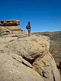 Overlooking Chaco Canyon
 Sunset at Chaco Canyon
Car: Chaco Canyon is located in northwestern New Mexico. The recommended access route to the park is from US 550 (=major road from Albuquerque to Farmington). Turn off US 550 at CR 7900 (about 3 miles southeast of Nageezi, and approximately 50 miles west of Cuba) at mile 112.5. This route is clearly signed from US 550 to the park boundary (21 miles). The route includes 8 miles of paved road and 13 miles of rough dirt road.
Allow 3 hrs driving time from Albuquerque. The distance from Albuquerque is 152 miles.
From the south, two routes access Chaco from Highway 9, which runs between Crownpoint and Cuba. Both routes can very from very rough to impassable. Not recommended for RVs. The route from 550 is the best.
Road maps to Chaco Canyon
Plane: The nearest airports are Farmington NM, Gallup NM, Durango CO, and Albuquerque NM.
MAP and Park Information
 Petroglyph of a scary man
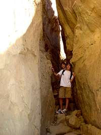
 Crawling inside the ruins
Map
The park is open every day from 7:00 am to sunset. The Visitor Center is open from 8:00 a.m. to 5:00 p.m. It is nice to stop at the visitor center and obtain some information about the site, hikes etc. You will also receive a map (the same one as link above).
Fee: Vehicle Entrance Fee is 8$ and it is valid for 7 days. This permit allows all persons traveling with the permit holder in one private, non-commercial vehicle to leave and re-enter the park for one week.
Individual Entrance Fee is 4$ for 7 days.
The park is popular with bicyclists. People bring their bicycles to travel in between the ruins. There are also several hikes inside and above the canyon, offering great views.
Hiking
 Pueblo Alto Trail
 Pueblo Bonito from the top of the cliff
There are several backcountry hiking trails ranging from relatively easy and leveled ones to some climbing up to 450 feet. You can obtain information at the visitor center.
Most visitors explore only the main ruins along the road, especially worth while are ruins of Pueblo Bonito, Chetro Ketl, Pueblo del Arroyo, Kin Kletso and Casa Rinconada.
You can get a great overview of Chaco Canyon from the top of the cliffs. I think that one of the best hikes is to hike up a trail leading to Pueblo Alto.
Information about hiking in Chaco Canyon, and National Park web
Camping
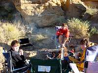 Camping with kids
 Dogs best friend
The camgroud has a front area - for large vehicles and caravans, and a smaller one in the back - for tents. It was very scenic, with cliff wall around and tons of petroglyphs on the cliff walls.
Camping is 10$ per day. First come first served basis. No reservations. Campers with Senior or Access passes pay 5$ per day.
Group Camping: there are two group campsites (10 to 30 people in each). Call for reservations.
Campground is open year round.
Campground information