Page Type Page Type: Mountain/Rock
Location Lat/Lon: 41.84757°N / 111.71688°W
Additional Information County: Cache
Activities Activities: Hiking
Seasons Season: Spring, Summer, Fall
Additional Information Elevation: 9539 ft / 2907 m
Sign the Climber's Log

Overview

Upper Dry Canyon
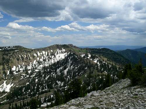
Flat Top from upper Dry Canyon
Flat Top is a very prominent mountain in the Utah half of the Bear River Range and rises to an elevation of 9,539 ft. It sits directly east of Smithfield, Utah in the Heart of the Mount Naomi Wilderness Area. Because of its position in front of the range's main crest it obscures the view of higher peaks behind it like Mt. Jardine and Mt. Elmer. It get's its name from its most obvious feature, its nearly perfectly flat top. However, it is not officially named on the USGS quad. Regardless of the mountain's level summit it is still a very rugged peak and requires a 7 mile (round trip) hike with about 4,500 ft. of gain.

The view from the top is amazing and takes in almost the entire Bear River Range as well as the Wellsvilles across the valley, the Northern Wasatch Range, and the Bannock Range in Idaho.

An exciting feature about this mountain is that it can be climbed in conjunction with at least one other peak in the Bear River Range. The summit of Flat Top is less than a mile north of Mt. Jardine and it is a quick and easy hike between the two. There is also the possibility of climbing Mt. Elmer in conjunction with these two peaks as its summit is only about a mile northeast of Mt. Jardine.
Mt. Jardine from Flat TopMt. Jardine from Flat Top

Getting There

Dray Canyon TrailheadDry Canyon Trailhead
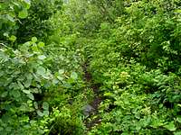
There are a number of approaches to Flat Top, the easiest of which is Dry Canyon located east of Smithfield. To access this canyon turn east off of highway 91 and onto 300 South in Smithfield. Follow this road all the way to its end at the wilderness boundary. The road goes strait to the trailhead with no need to turn onto any other roads. The last mile or so becomes a little rough but is still passable by passenger cars. About 50 yards from the trailhead the road becomes too rough for cars but there is a large parking area and it is a quick walk to the trailhead.

Brushy TrailThick Brush
The trail in Dry Canyon is in good condition but the brush is very thick on both sides so it almost feels like a serious bushwhack. The trail climbs at a pretty constant grade to a spring called Red Ledge Spring where water is available. From here the trail gains elevation quicker by switchbacking up the mountainside to the 9,000 ft. pass between Flat Top and Mt. Jardine. From the pass it is an easy hike up the ridge to the north to the summit of Flat Top. The true summit is located at the northern end of the peak.

It is also possible to approach the peak via Smithfield Canyon north of the peak but it is a much longer route.
Jardine Elmer CliffsThe Jardine-Elmer Cliffs

Red Tape

Flat Top is located in the Mt. Naomi Wilderness Area so there is no motorized travel allowed.
Naomi from Flat TopMt. Naomi from Flat Top


Bring plenty of water as there is very little to be had along the trail. Red Ledge Spring usually has some but be prepared in case everything is dry.

Please practice Leave No Trace

Weather


Camping

There are no established campsites in Dry Canyon but plenty of places to camp. The best places are lower in the Maple forests at the bottom of the canyon or in the meadows East of Mt. Jardine. There is evidence of people camping right on the summit of Flat Top but it would be a very exposed site.

External Links

The area is administered by the Logan District of the Wastach-Cache National Forest.
The TopThe Summit Ridge


Children

Children

Children refers to the set of objects that logically fall under a given object. For example, the Aconcagua mountain page is a child of the 'Aconcagua Group' and the 'Seven Summits.' The Aconcagua mountain itself has many routes, photos, and trip reports as children.