
-
 10103 Hits
-
 83.69% Score
-
 17 Votes
|
|
Mountain/Rock |
|---|---|
|
|
43.84000°N / 109.2898°W |
|
|
Park |
|
|
Hiking |
|
|
Summer, Fall |
|
|
12156 ft / 3705 m |
|
|
Overview
 Cascade Peak
The Southeast Absaroka Range is a wild and rugged place that contains hundreds of beautiful peaks that are rarely climbed; many require long approaches, but the peaks around the ghost town of Kirwin are an exception. A trail head that is arguably the finest place in Wyoming for accessing high peaks in a very short distance, Kirwin is a wonderful place to visit if you like solitude and lonely summits that make you feel like you are the only person to ever stand on them.
Most of Cascade Peak is hidden from view from the trail head by Spar Mountain, which looms over Kirwin to the south. However, once you enter Cascade Creek Basin, the long and impressive walls on the north side of the peak dominate the valley. From dozens of other peaks in the area, Cascade Peak's long ridge is an easily recognizable landmark; at 12,156 feet, the mountain has 976 feet of prominence and is the 174th highest peak in Wyoming.
A note on the name: This peak is listed on the topo map as simply Cascade. The Lists of John site lists it as Cascade Benchmark, and someone who has posted pictures of it on GoogleEarth refers to it as Sleeping Bear Mountain; after a little research, I believe the latter title is completely bogus and I have no idea where it comes from! For the purposes of this page, I'm using Cascade Peak.
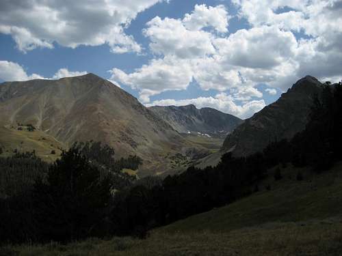
 Cascade Creek Basin
Getting There and Climbing Information
Climbing Cascade Peak involves a drive to the Kirwin trailhead. 4WD is recommended, but high clearance and AWD will suffice under most warm-weather conditions. Kirwin was a mining boomtown many years ago, and several structures still remain in the area. The ruined townsite is a popular destination for locals who like to drive up for lunch and a tour, but few people outside the area know anything about Kirwin and the awesome trail system it accesses. Kirwin is also one of the most beautiful trailheads in the Rockies, with towering, brooding mountains all around it. Kirwin
 Wolf Creek Mine
From Meeteetse, 32 miles south of Cody, turn west onto the signed road for Wyoming 290. In 6.4 miles, turn left onto Wood River Road. At 11.6 miles, the pavement ends. The national forest boundary is at 21.7 miles. Pass Wood River Campground at 22.4 miles and Brown Mountain Campground at 24.8 miles. The road now gets a little rougher, but it is not real 4WD stuff. At 26.8 miles is the first of four stream crossings. This one is short and usually shallow. The second river crossing is at 27 miles. This one is wider and deeper. The third crossing, which is actually two crossings in quick succession, is at 29.3 miles. These are broad but shallow. The last two miles to the trailhead are rocky but not anything to get nervous about. There is one more stream crossing just before the trailhead, but it is a tributary stream and may even be dry. The trailhead is at 33.1 miles.
Directions above used with permission from Bob Sihler's Kirwin page.
There are two roads that lead through the longest river crossing. When heading to Kirwin it is hard to find the left fork, so you shouldn't have a problem staying right; in the summer of 2008 there were pink ribbons tied to stakes and trees marking the route through the water. On the way back out, stay to the left in the trees when you reach the fork unless you want to spend a lot of time driving in the water and trying to figure out where the road goes. In July 2010, half of the right fork of the road after the crossing was underwater and was an interesting drive.
Pay close attention to recent weather before going to Kirwin, as rain and spring runoff can make the crossings very interesting. My wife and her parents were up there in June 2005 in a Jeep Cherokee that left the ground and floated for a few moments during an afternoon crossing in the middle of spring runoff!
 Falls on Cascade Creek
 Approaching the mountain
Start your hike at the west end of the Kirwin parking areas where the locked gate shuts off the road that becomes the East Fork Trail; cross over the Wood River (no more than a large creek at this point) on the wooden footbridge and head over to the town of Kirwin, where the remaining buildings from this century-old mining town are open to see and explore. Bring a flashlight if you want to see inside most of them, as a lot of the rooms are totally dark. Stay on the main road and bypass Kirwin on your left to start up onto the side of Bald Mountain. The road is wide enough for a fairly large truck, but it has been closed off for a number of years; there are several trees that have fallen across the road, but these are not hard to get over. There is also one point where a stream crosses the road, but it's not very wide unless there has been a lot of recent rain. The are several side roads that branch off the main one, but these are starting to be overgrown with young pine trees, so it's probably best to stay on the main road.
 The last few hundred feet
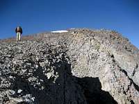 Nearing the summit
After about a mile of lengthy switchbacks and about 1,000 ft. of elevation gain, you will find yourself above the treeline. As you leave the trees, you will cross above a large mine in the hillside. The are numerous trails and roads up here, but look to stay right and pass below the two partially completed cabins soon after the mine. If you see these cabins on your right, you are too high and should head straight down to find a lower trail. The trail will take you down into a small gully before skirting around the bottom of the small area of trees on the side of Spar Mountain. You are now on the Cascade Creek Trail, and before long the trail crosses over the creek onto the side of Mount Sniffel. The size of the creek will vary depending on the season, but it is an easy crossing. This trail will follow the creek pretty closely for about a half of a mile before forking; the Cascade Creek Trail stays to the right and starts heading up around to the back of Mount Sniffel, while the Smuggler Gulch Trail stays left and crosses back over the creek. Take the left fork and head towards Smuggler's Gulch Pass between Spar Mountain and Cascade Peak. If stream crossings are not your thing, keep to the left of the trail and do some easy scrambling to the left of the waterfalls to stay on the left side of the creek until you pick up the trail again.
 Wildflowers on Smuggler Gulch Pass
Cascade Peak is the the apex of the rugged wall that dominates the view to the south as you hike through Cascade Creek Basin. The trail heads up a series of switchbacks on a grassy ridge, gaining about 1,000 feet in a little over a half mile of trail, reaching an elevation of 11,566 feet at the top of the pass. This is a typical Kirwin trail; it is steep, exhausting, and your lungs will be be burning before you are halfway up!
Once you reach the pass, head to the right and ascend the easy slopes for another 600 vertical feet to the summit, which is marked with a cairn. The views to the south extend over the Washakie Wilderness to the steep spires of the Washakie Needles, and on a clear day the major peaks of the Wind River Range are visible to the southwest. The views in all other directions extend over a sea of mountains, cresting over countless drainages as far as the eye can see.
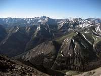 Summit view south
 Summit view north
The hike to the summit of Cascade Peak is Class 1 with a few easy off-trail sections; the distance to the summit is 4.5 miles with about 3,000 feet of elevation gain.
 Cascade Peak's east ridge
Red Tape and Camping
There are no permits required to hike in this area; the Meeteetse Ranger District can be reached at 307-868-2379 for any questions on access.There are grizzlies in this area, so know how to hike in bear country! Bear spray is a must, and make as much noise as possible, especially when you're on a trail in the trees.
The nearest campgrounds (Wood River and Brown Mountain) are quite a ways down the road, which I think would be a pretty wild drive in the dark if you're trying for an early start to your hike. I've spent many nights sleeping in my car at Kirwin; the restroom is always open (at least in the summer), but you'll have to bring in your own water or filter some from the river. There is a visitor's sign-in at the information center next to the restroom. As Bob mentioned in his directions above, this is not a well-known place; there are maybe two cars a day that visit during weekdays. If you like solitude and wild country, this is a great place!
 Cascade Peak framed by Spar Mountain (left) and Mount Sniffel (right)