
-
 3642 Hits
-
 79.78% Score
-
 11 Votes
|
|
Mountain/Rock |
|---|---|
|
|
46.74636°N / 11.41147°E |
|
|
Skiing |
|
|
Summer, Fall, Winter |
|
|
7999 ft / 2438 m |
|
|
Overview
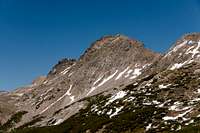
 Hoferberg seen from Karnspitz / Cima di Quaire Hoferberg seen from Karnspitz / Cima di Quaire |
Here we have a rare specimen of a mountain: the highest and easily most impressive mountain of its ridge, twin peaked with two rocky summits, a south face which drops impressively on the meadows underneath - and yet none of the maps you consult shows any name. The mountain does not belong to some obscure Asian or African mountain range, it is located in Europe, in the middle of the Alps, not far away from the busiest thoroughfare through that range, the Brenner Motorway. The mountain belongs to the Sarntal Alps / Monti Sarentini, and there belongs to Gentersbergkamm / Cresta Ganda, a long though somewhat low ridge which protrudes into the horseshoe-shaped greater range.
 |  |  |
As said above, none of the maps I consulted could tell me the name of this mountain but then I found a guidebook, in which the traverse across Gentersbergkamm / Cresta Ganda is described. The description once mentions a Hoferberg between Karnspitz / Cima di Quaire and Gentersbergspitze / Monte dei Masi, the mountain in question !?! Since Google also doesn't seem to know this mountain let us also designate it by P 2438, from the elevation of its main summit.
Hoferberg has two summits of similar size. The eastern summit is the higher one, reaching 2438m while the western summit reaches only 2416m. The summits are separated by a small saddle to which the steep ridges of the summits drop. While most of Gentersbergkamm / Cresta Ganda is rather wide, at Hoferberg it narrows to a knfe-edge. Unfortunately the rock quality is of Sarntal Alps standard, a brittle mixture of schist and quartzite. While the north faces of the two summits are steep angled slopes the south faces are much steeper, nearing the vertical for the main summit.
 |  |  |
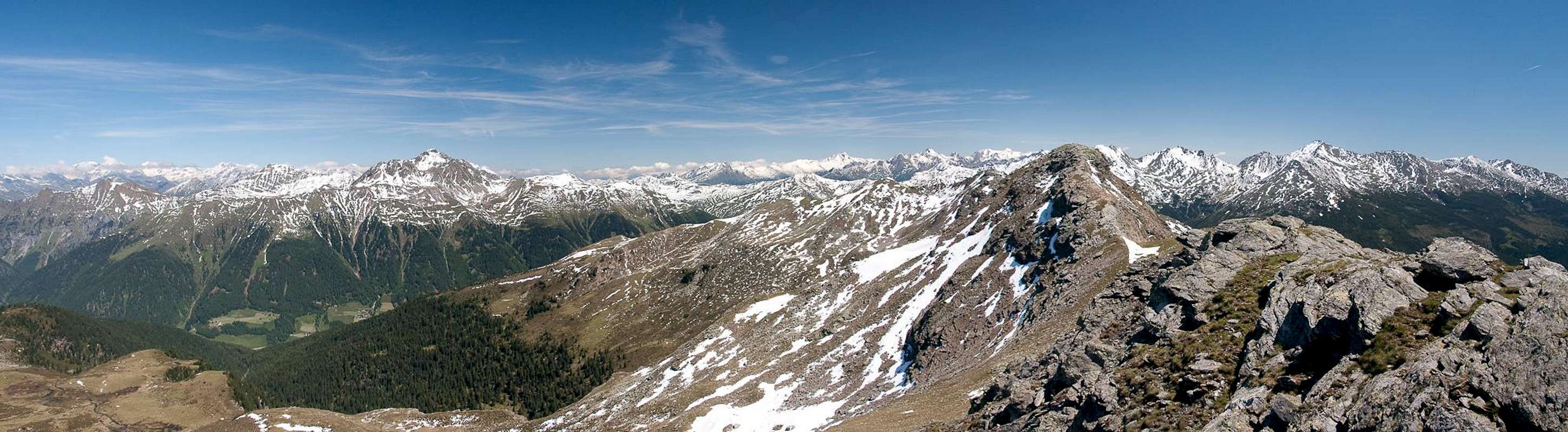
Thanks to the lack of advertising on any maps, Hoferberg is rarely climbed, but for a traverse of the whole Gentersbergkamm / Cresta Ganda. Still it is one of the best lookout peaks in all of the Sarntal Alps, a range not exactly devoid of famous viewpoints. Hoferberg stands out thanks to its relatively modest elevation which nevertheless exceeds its neighbours. The surrounding mountain ranges then appear layer by layer behind each other.
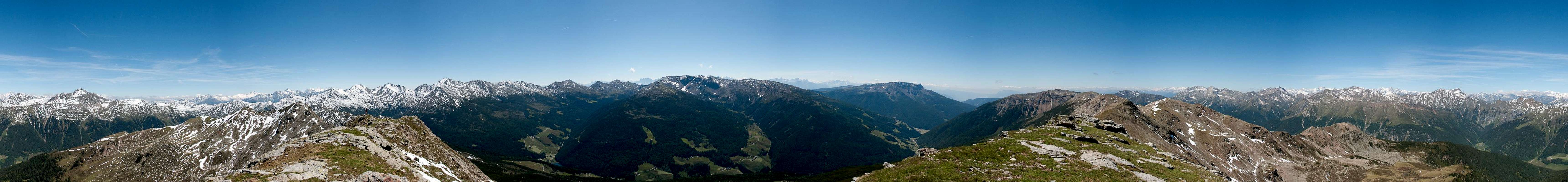
360° Summit Panorama
  |
Getting There
 Hoferberg main summit
There are two reasonable trailheads for Hoferberg / P 2438, one at Durnholz / Valdurna one in Pens / Penes, both in Sarntal / Val Sarentino
- Durnholz / Valdurna trailhead
- Take Brenner Motorway A22 to Bozen / Bolzano
- Drive through the city, following signs to Sarntal / Val Sarentino on SS508
- At Astfeld / Campolasta turn off onto SP137, direction Durnholz / Valdurna. You have to park outside the village and will be charged a fee of 3€.
- For Pens / Penes stay on SS508 until you reach the village. You can also reach the village from Sterzing / Vipiteno across Penser Joch / Passo di Penes (also SS508).
Red Tape
 |
There is no red tape in this area. Except for a few sheep and goats the area is not used for farming. In Durnholz / Valdurna you will have to pay a fee of 3€ for parking.
Accommodation
 Geisler Group seen from Hoferberg
Eisacktal / Valle Isarco
Bozen / Bolzano
Weather Conditions
Maps & Books
Maps
- Digital Maps
- Regular Maps
- Sarntal/Val Sarentino
Kompass Map WK 056
1:35.000
ISBN: 3-85491-340-0
- Brixen / Bressanone
Kompass Map WK 56
1:50.000
ISBN: 3-85491-063-0
- Bozen / Bolzano
Kompass Map WK 54
1:50.000
ISBN: 3-85491-061-4
- BOLZANO-RENON / BOZEN-RITTEN-TSCHÖGGLBERG
Tabacco Map 034
1:25.000
- MONTE SARENTINI / SARNTALER ALPEN
Tabacco Map 040
1:25.000
- Sarntal/Val Sarentino
Books
- Bozen-Salten-Schlern
Kompass Guidebook WF953
Kompass Verlag
ISBN: 3-85491-406-7
- Rund um Bozen
Helmut Dumler
Rother Verlag
ISBN: 3-7633-4267-2