
|
|
Area/Range |
|---|---|
|
|
46.00972°N / 11.52303°E |
|
|
Mixed |
|
|
7664 ft / 2336 m |
|
|
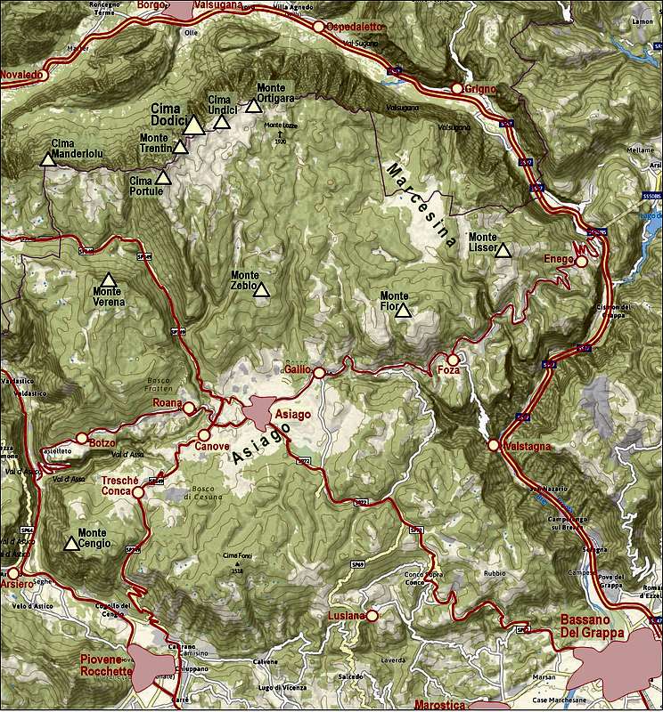
Asiago Tableland
Overview
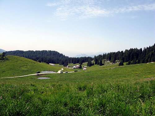
The group of Prealpi Venete e Trentine is a big mountain area of Southern Alps, stretching northwest of Venezia. An important part of it is the well known area, referred as Sette Comuni (Seven Communities), occupying the biggest among high plateaus of the area. So, the Sette Comuni Plateau (Asiago tableland) is a big range of mountains, sweet meadows and woods, south of Valsugana (Brenta river valley). Its N border is made by a long ridge that to the N has high rocky and very wild walls (1500 m high), to the S slope are lowering down more gently, at the beginning with wild stony walleys and ribs, then with a big band of meadows and, after the main road (from Vezzena to Asiago) ends to the S with big wooded ribs.Asiago Plateau is a paradise for all sorts of outdoor activities. Having on the south a dense populated North Italian Plane with big cities like Vicenza, Padova, Venice and others, people on the plateau developed a range of tourist activities. Hiking and mountaineering is only a small part of tourist offer. In summer time you will find there all kinds of other activities, among them biking and riding. In winter time cross country skiing is very developed and to a lesser degree also classical skiing. In Asiago and around also some world class sport events are being held each year.
Considering only hiking and mountaineering, you will find on the mountains of Asiago Plateau really nice opportunities for less demanding, but panoramic and scenic hikes. In combination with a mountain bike the range of tours is even much broader. As of classical climbing and more demanding mountaineering tours, there are only a few opportunities on the northern side of the main crest.
The Cima Dodici - Ortigara range
The high parts of these slopes are crossed by a big net of military (1st WWW) unpaved roads) perfect for Mountain Bike and for cultural/panoramic hikes, some of this roads are open to private trafic so that you can save many hours walking to approach the summital ridge.
Vezzena Pass 1428m.
 Pizzo di levico | 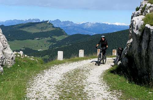 Bocchetta delle Portule | 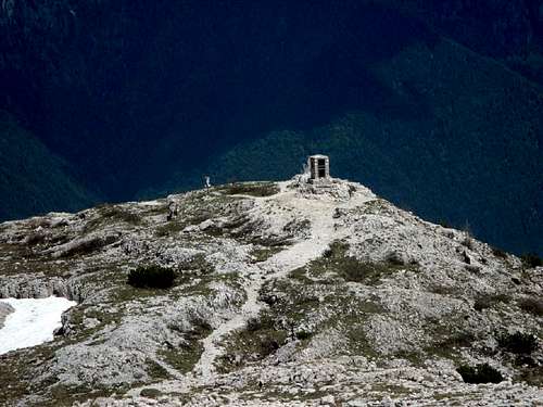 Mount Ortigara |
A Quick Geographical Overview
The northern and eastern border of the area is Valsugana with Brenta river. Towards the south, the high plateau first drops quite steeply, but then the hilly area stretches all the way to the big North Italian Plane (Po river plane). The western border is Valdastico, but not till its end. In the middle, near its knee, a side valley (Val Tora) comes down from the north, dividing the plateaus of Luserna/Lavarone and Asiago. The dividing line further towards the north in not clear, but more an arbitrary one. On our page we shall be mentioning also Cima Manderiolu as the northwestern corner of the area.
That is Asiago Plateau in a narrow sense. A bit broader area includes also the summits more towards the west, above the plateaus of Vezzena, Lavarone and even Folgaria.
All high mountains of the Asiago Plateau group are lined on the northern border of the plateau. That's the main spine of the area, the crest which is beautifully seen from the north, from Valsugana. From Cima Dodici, the highest mountain, to Borgo Valsugana by Brenta river, the altitude drop is almost 2000 meters. The northern faces of those mountains are steep and rocky, so very picturesque. South of the main crest there is a high plateau on the altitude of 1800 m - 2000 m. From that one many rounded side ridges are going southwards. In them we can still find summits exceeding 2000 m, in the southern area there are some quite popular summits of around 1600 m - 1800 m. Only further towards the south the biggest, central part of the Asiago Plateau begins. Its edge on the south is a long ridge of lower summits which is finally lowering down to the foothills and the plane. On the northeast a nice plateau of Marcesina should be mentioned as well. The last distinct feature to be mentioned is the valley of Assa creek, west of Asiago. It is encircling Monte Verena, making it a quite high and handsome mountain. By the upper valley of Assa the road goes, connecting Asiago with Lavarone.
Getting On the Plateau
From Far Away
BY RAIL & CAR: You can reach Trentino from the north and south either by rail Verona-Brenner-Munich or on the A22 Brenner motorway.
Local transport includes bus services run by the Trentino Trasporti and two minor railways, the Trento-Venice through Valsugana.
Roads To Asiago
The plateau is most often reached from the southern side. The fastest approaches are:
> From Piovene-Rochette, where the highway ends, a good, quick road goes up towards Asiago.
> From Bassano del Grappa a good road ascends up on the plateau from the SE side. Several side variants along that road are also possible.
> From Valdastico a road goes up to Asiago along the Assa valley (through Botzo and Roana).
> From Valsugana a good road goes up via Enego and Foza. Coming from the south, you can take also a road up to Foza from Valstagna.
> From the W (from Lavarone Plateau) a good road goes to Asiago over the plateau of Luserna and the Assa valley.
All other trailheads lie down in the valley of Valsugana.
Roads To High Plateaus
Being already on the Asiago plateau, you can take a few mountain roads up towards the higher regions. More important trailheads are mentioned on specific mountain pages. If you opt for bike & hike tours, Asiago itself can be a good starting point. Spending for example a week there you could visit most of the important mountains, approaching them by bike. In that case you'd need to do 1200 or some more altitude differences per tour.
The main accesses (by car) to the high plateaus above Asiago are:
> Malga Larici (12 km from Passo Vezzena + 6 km from the road Vezzena-Asiago) - for Cima Portule range.
> Malga Galmarara (from Camporovere toward Trento for 4 km then on the right for 7 km) - Cima Dodici range.
> Piazzale Lozze (15 km from Gallio) - for the Ortigara range.
 Porta Manazzo |  Mount Ortigara | 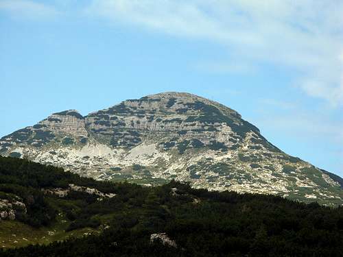 Cima Dodici |
Towns Around the Plateau
In the valleys around the plateau there are many nice Italian towns, worth a visit. Some of the highlights are:
Borgo Valsugana. The ancient Ausugum lies on the Ancient Roman road, connecting Altino (near today's Venice) with Tridentum (now Trento). The town always benefited of trade but was burnt down in 1862 by a huge fire. Nice town to walk through, see the main square, a few churches and Castel Telvana above the town.

Bassano del Grappa

Marostica
Marostica. A pleasant medieval town, still behind picturesque ramparts. Below its castle the town enjoys a sunny position. Beautiful is its main square with palaces around. The town is famous for its chess play. Once every year, second week in September, a party of chess is being played, where chess figures are live people in costumes. A lively and picturesque costume event is built around the game.
Asiago. The town is on the plateau itself, of course. Its old Cimbrian name is Slege, German is Schlaegen. The town is famous of the events in the World War I and nowadays also of its delicious cheese. Today it lives mostly of tourism.
Summits Above Asiago Plateau
Hiking highlights are on the northern crest of mountains, where the highest peaks are rising. With a smart logistic the whole higher part of the crest could be even done in one long day, otherwise sleeping in the bivouac below Cima Dodici can break the crossing into two days. From the summits one can enjoy great views around, especially towards the north and north-east, on Lagorai and Dolomites mountains. By the easiest routes mountains are not hardly reachable and all along the crest also marked paths go. Here are the summits, listed from the west to the east:Main Crest
Pizzo di Levico (Cima Vezzena or Spitz Verle), 1908 m. A panoramic summit with a fortress.
Cima Manderiolo, 2049 m. Already almost above the neighbouring Vezzena plateau. Can be reached by the ridge marked path (No. 205) or from the nearby alpine meadows.
Cima Larici, 2033 m. Above Malga Larici, 1658 m, easily reached from there (path No. 825) or by the ridge path (No. 209).
Monte Erba, 2031 m. Eastern neigbour of Cima Larici, just some 500 m away.
Monte Kempel, 2295 m. Ridge summit, where the strong southern ridge of Cima Portule joins. Ridge path No. 826 crosses it.
Cima Portule, 2308 m. Important summit in a strong southern side ridge. Can be ascended from the ridge path by the path No. 826, or from the south, from Bocchetta Portule.
Monte Trentin, 2325 m. The second highest summit, the ridge path (No. 208) crosses it.
Cima Dodici, 2336 m. The highest summit in the middle of the range. Paths are reaching from three sides and to the neighbouring bivouac also from the north.
Cima Undici, 2228 m. Path 206 crosses below the summit.
Cima del Pra, 2213 m. Summit, a bit indented from the main ridge.
Monte Castelnovo (Cima Dieci), 2215 m. A picturesque, steep mountain abowe a wild gorge, southern side overgrown by grass and dwarf pine.
Monte Ortigara, 2106 m. Not high elevation above the high plateau, but a mountain-monument, famous from the World War I.
Cima della Caldiera, 2124 m. The easternmost high mountain in the range, can be reached by three marked paths.
More towards the east and south-east mountains on the edge of the plateau are a bit lower, all below 2000 m. Marked paths are mostly passing by. Some summits are: Punta Molina, 1920 m, Cima Isidoro, 1912 m, Castelloni di San Marco, 1830 m, Monte Astealte, 1740 m.
 |  |  |  |  |
Trentin Valley and M. Trentin 2310m
Cima Portule 2308m from Pizzo di levico
South of the Main Crest
The view from below Monte Corno
Monte Verena, 2015 m. It is an exception, rising quite high above the Assa valley. Easily reached from the south, big fort on top.
Monte Zebio, 1819 m. Another mountain known from the World War I. Easily reached from the alpine meadows below it.
Monte Fior, 1824 m. Grassy summit above alpine pastures. Beautiful rock formations, mountain known also from the World War I.
Monte Lisser, 1634 m. Ski resort and moutain road on top. Big fort on the very summit.
Monte Cengio, 1354 m. Another legendary mountain from the World War I. Memorial parc nearby, vertical drops towards Valdastico.
 M. Verena |  M. Zebbio |  M. Fior |  M. Lisser |  Kaberlaba |  M. Cengio |  M. Corno |
A Few Unusual Hikes
The usual hikes on the most prominent mountains are described on separate mountain pages. They are too many to even list the most attractive ones. But it is unlikely that some hikes to natural and cultural pecularities will get their own pages. Still, when being around, and it's no time for bigger tours, it's worth doing them.Cult Places and Archeological Sites
Altar Knotto or Alte Knotto (old rock) above Rotzo. It's an big, unusual rock formation which looks like hanging out of equilibrium on the edge above Valdastico. Supposedly it is connected with Celtic rituals (even sacrifying people). Nearby are also two other interesting places: Altaburg and Alta Kugela. Speculations also connect Altar Knotto with two other similar places on the plateau: Hanepos and Spitzknotto, thus forming a "magical" triange. The rock is reached in 1 h 45 min from Rotzo, first by a mountain road, then by a good path.

Bostel

Tunkelbald archeological site
Graffiti in Val d'Assa. In the creek bed below Roana there is a prehistoric place called Tunkelbald, with many carvings in vertical limestone walls.
Spitzknotto or "Terzo Altare" (Third altar) is an interesting promotory, made of unusual rock formations above Val Frenzela. It can be reached by an easy path from Stoccaredo di Gallio.
Natural and Other Cultural Heritage
Cala del Sasso in Val Vrenzela is an amazing path uphills, which was used centuries ago for trading (the shortest ascent from Valsugana - Brenta valley to Asiago plateau). It consists of 4444 stone steps which make an altitude difference of 750 m. That is supposedly the longest such stairway on the Earth. Below the trail starts near Valstagna, above it ends near Sasso di Asiago.
Castelloni di San Marco, a rock labirynth with many karst phaenomena. Nearby is also the misterious Hanepos stone. A 3 hours marked path brings us to the area on the edge above Valsugana from Malga Fosetta, north of Gallio.
And there are many more natural features, worth of visiting: caves, canyons, a few waterfalls, a few valleys with paths connecting picturesque old moulines, etc.
World War I on Asiago Plateau
During the World War I Asiago Plateau was a theater of some of the most fierce battles. The frontline moved across the plateau, but no ultimate breakthrough was made there, even if during the so-called "Strafexpedition" Austro-Hungarian army was close to it. On subpages of Monte Ortigara, Monte Fior and Monte Cengio some local events are described, below is a more general course of war in these areas.The Course of War Events
On May 24th heavy guns of Forte Verena opened fire towards Vezzena. Italy entered the war. First Italian offensiove was not effective, but next year, in May 2016, Austro-Hungarian army launched a very effective "Strafexpedition" (Punitive Expedition), which resulted in conquering Asiago and reaching almost the North Italian plane. Asiago and Gallio were completely demolished by bombarding. But Austro-Hungarians had to retreat and after June 16th their army took positions along the line in the upper part of Asiago Plateau. Next year there followed an Italian attack. In June 1917 there was the Battle of Ortigara, one of the bloodiest and useless massacres, after which nothing was strategically gained and lost on any side, except tenths of thousands of lives. In autumn 2017 a break through was made elsewhere (at Kobarid, on the east) and Italian army had to retreat to the line Piave-Grappa-Altopiano. In November and December Austro-Hungarians attempted another break through at the edge of Valsugana, but were not successful. Next year big artillery battles took place at "Tre Monti", then in June 1918 along the whole frontline Austro-Hungarians made the last attempt of a big offensive. Despite big losses on both sides the offensive was not successful, in October Asiago and Gallio were re-taken by Italians. On November 3rd, 1918 all weapons were silenced.
Big Fortresses of Asiago Plateau
On Asiago Plateau, as on other nearby plateaus, a worthwile goal of visit could be big forts which were built before the World War I and took some role during the war. West of the Asiago Plateau a 100 km long tour exists, connecting the big fortresses of Altipiani. The tour can be done by car, with some additional hiking, or, much nicer and more enduring, by bike. In summer also a bike race is organised by that route. But that route does not touch the forts on Asiago Plateau. Still, they can also be reached in a similar manner, either one by one, or by some connecting itineraries. The biggest forts are:
| Forte Verena, 2015 m. Forte Campolongo, 1720 m. Forte Interrotto, 1392 m. Forte Corbin, 1077 m. Forte Lisser, 1633 m. |  Forte Verena |  Forte Lisser |  Forte Corbin |
Cimbri
Cimbri are an interesting ethnic and linguistic minority on SetteComuni plateau and on some places on Monte Lessini. Their origin is still shrouded in mystic and their language is a hard walnut for linguists. Their origin is German, supposedly the tribes moved southwards even from as far as from Jutland, Danemark. The strongest enclave of Cimbri people is nowadays in Lusern, a small, remote town west of Asiago Plateau.Mountain Huts and Bivouacs
If you have in mind mountaineering and hiking, On Asiago Plateau there are not many huts where you can spend night and get service. Actually there's none. The game is different there. On alpine meadows thera is a lot of tourist farms (agriturismi), and that's even much better, because there you can get all those delicious local products.The second specific are shelters in buildings from the World War I. Such a "ricovero" can be all the time opened and if you bring a sleeping bag and some food, you can spend a night there. Many such bivouacs are on the southern side of the main crest. The only modern mountaineering bivouac is Bivacco Busa delle Dodese, 2080 m, east of Cima Dodici. Actually, if you have a car, the ascent on all summits can be done in one day, so sleeping on a mountain is not needed. For longer treks those bivouacs are welcome.
When To Come?
The mountains of Asiago Plateau can be visited any time of a season. Also in winter time many ascents can be done as ski tours. On many places on the plateau long and nice cross-country ski tracks are arranged and you can there enjoy also in other winter sports.External Links
Asiago tableland on Magico Veneto
A.P.T.Asiago
Vezzena e Lavarone
Valsugana - the NW border of Asiago tableland
|

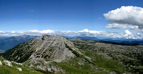
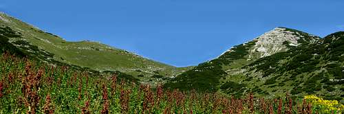
Pizzo di Levico - pano toward East
|

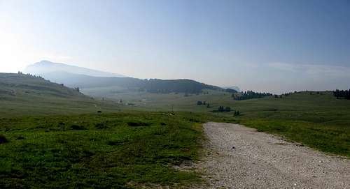
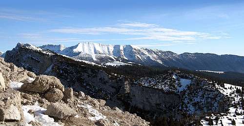
Bivio Italia - pano 180° - Kaiser Karl Strasse
|

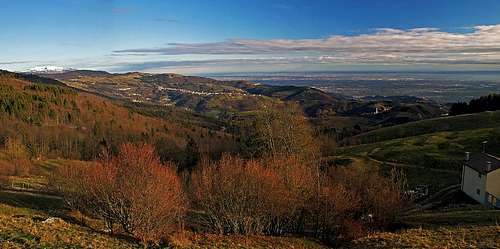
Ortigara - pano toward North and East
|
