
-
 7699 Hits
-
 84.27% Score
-
 18 Votes
|
|
Mountain/Rock |
|---|---|
|
|
43.91510°N / 109.28318°W |
|
|
Hiking, Scrambling |
|
|
Summer |
|
|
12003 ft / 3659 m |
|
|
Overview and Route Information

The only named peak among several that almost completely encircle beautiful Meadow Creek Basin, Chief Mountain treats the few that climb it to spectacular views of some of the Absaroka Range’s highest and wildest mountains. Easily done in half a day or less by strong climbers, the peak can also be part of a full-day or overnight excursion that will involve scenic alpine ridge walking and several more summits. For example, one can head north to Francs Peak, the highest peak in the Absarokas and one of only four Wyoming 13ers outside the Wind River Range, or traverse south to Brown Mountain and from there down to Kirwin, which is four road miles from the Meadow Creek trailhead (please see the attached route page for more details).
Chief Mountain is not in a federally designated wilderness, but it is in a remote and roadless section of Shoshone National Forest and has as much wilderness character as the protected regions only two miles from it. Why it and Meadow Creek Basin are not part of the Washakie Wilderness is something I don’t know, but I suspect that it has to do with mining claims in the area or the possibility that mining scars have left the area ineligible for wilderness appellation.
Route Information
Basic Details: Approximately four miles to the summit, 3700’ of elevation gain; Class 1 trail for three miles and then Class 2 or 3 conditions to the summit.
 Route information with photo caption-- please click to view.
From the trailhead, hike three moderately steep miles (8300-9900’) until Meadow Creek Basin opens before you. This basin is simply beautiful, and even jaded climbers bored by trail scenery after what they have seen from the mountaintops will admire this place.
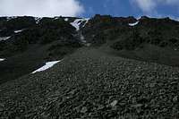
As you enter the basin, the trail turns right to cross the stream in order to avoid a massive boulder pile. Although you can cross the stream and climb Chief Mountain from higher in the basin, the fastest and most direct route is via that boulder field. Clamber up it, study the slopes above, and choose what way best suits you. You can keep it at steep, often-loose Class 2, but there are also many sections that offer sustained, enjoyable Class 3 and 4 scrambling. As I have said many times, I prefer a climb to a slog, so I did as much scrambling as I could.
 Route Route |
 |
 Summit Summit |
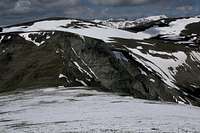
Above the good scrambling sections, a summit appears just to the left and a couple hundred feet up, but that is not the actual summit, so do not head for it. Instead, attain the ridge crest to its right and then make an easy finish right (southwest) to the real summit, where there is no register (and, in my opinion, there doesn’t need to be one).
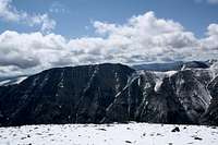
 Views... Views... |
 |
 |
 |
 |
 |
 |
Getting There
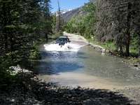 Yours truly plowing through the Wood River-- photo by musicman82.
 Trailhead sign-- photo by musicman82.
If you have the right vehicle (high clearance, and four-wheel drive is a good idea as well), part of the fun in getting to Chief Mountain is the drive to the trailhead, for there are stream crossings that, depending on the time of year and recent conditions, can range from splashes to white-knucklers to good ways to find out how well your vehicle works as a boat. Unless you can see that an entire crossing is shallow, take the time to get out and check the conditions before driving through. When the crossings are low enough to ford, four-wheel drive is typically not necessary, but I like to use it for the extra power and traction when going through.
Except for the stream crossings, the road does not have any major obstacles unless recent conditions have caused washouts. There are rocky sections, and the road gets rockier the farther you go, but there is nothing a moderately experienced off-road driver really needs to worry about.
However, there are some sections, especially before any of the stream crossings, where the road is far more dirt than rock, and if it is raining or there has been rain in the past couple of days, the road is likely going to be treacherously slick mud in those places. To make matters worse, these spots tend to be where the road is narrow and hugs a steep hillside, meaning that if you lose traction and go off the road, you are not going to get stuck but rather are going to go crashing and/or tumbling down the mountainside. If you are inexperienced with four-wheel drive conditions, I recommend turning back if the road is like this, but if you must go on, shift into 4-Lo (if your vehicle has a transfer case) and go very slowly, using enough power to keep moving but not to make the wheels spin. If you don't have a transfer case, downshift to first gear.
So here are the directions:
Remember that odometers can very slightly. In two different vehicles, I have gotten two different measures here, but both were within a mile of each other.
From Meeteetse, 32 miles south of Cody, turn west onto the signed road for Wyoming 290. In 6.4 miles, turn left onto Wood River Road. At 11.6 miles, the pavement ends. The national forest boundary is at 21.7 miles. Pass Wood River Campground at 22.4 miles and Brown Mountain Campground at 24.8 miles. The road now gets a little rougher, but it is not real 4WD stuff. At 26.8 miles is the first of three stream crossings, at Jojo Creek. This one is short and usually shallow. The second river crossing (Wood River) is at 27 miles. This one is wider and deeper. The third crossing (Wood River), which is actually two crossings in quick succession, is at 29.3 miles. These are broad but shallow. The trailhead for Meadow Creek is at 30 miles, on the right (north) side of the road. As of July 2010, there was a rusty metal sign marking the trailhead.
You can continue past this point for four miles to the trailhead and old townsite of Kirwin. There is one more stream crossing, of a stream draining Brown Basin, just before the trailhead, but it is a tributary stream and may even be dry. It takes me about 75 minutes to make the drive to Kirwin.
REMEMBER: Conditions can change. In 2010, there were water crossings that were not there during my visits in 2001 and 2007. In one spot, the stream and the road were the same for about a quarter-mile. Be prepared for a driving adventure.
It's a long drive in. It would be wise to check with the local ranger district about any access restrictions before heading in. Call 307-868-2379 (Meeteetse Ranger District).
Red Tape
No fees, no permits. What you must always keep in mind, and prepare accordingly for, is that this is grizzly country, and the Absaroka Range has the most and the best grizzly habitat in Greater Yellowstone. If you are not comfortable being in grizzly territory or do not know how to prepare/react properly, please do not come out here; you may end up getting yourself and the bear killed.Camping
Camping is available at the Wood River and Brown Mountain Campgrounds (see Getting There about directions). The sites go on a first-come, first-served basis, and there is a $10 camping fee. Water and pit toilets are available at both.You could also sleep in your car at or near the trailhead. I am not sure if dispersed camping is permitted; in many parts of grizzly country, camping is allowed only at established campgrounds.