
-
 4976 Hits
-
 82.48% Score
-
 15 Votes
|
|
Mountain/Rock |
|---|---|
|
|
46.76309°N / 11.49157°E |
|
|
Hiking, Scrambling |
|
|
Summer, Fall |
|
|
8993 ft / 2741 m |
|
|
Overview
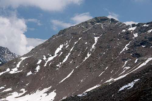 Jakobspitze / Cima di San Giacomo seen from the west Jakobspitze / Cima di San Giacomo seen from the west |
The most important mountains of the Sarntal Alps are located to the north and east of the horseshoe shaped range. With 2781m Hirzerspitze / Punta Cervina, the highest of them is located in the north-west, surrounded and accompanied by most of the other high mountains of the range. Its counterpart on the eastern side is Jakobspitze / Cima San Giacomo, central and highest mountain of the eastern half of the Sarntal Alps. Over all, it is the fourth highest mountain of the range.
Like all mountains on the eastern ridge of the Sarntal Alps, Jakobspitze / Cima San Giacomo is composed of an ugly mixture of schist, gneiss and porphyry. Its slopes look like giant rockfall areas, strewn with blocks of all sizes. The ridges are even more brittle. Here schist dominates, making the ascent routes uncomplicated, yet dangerous. Three ridges lead up to the mountain and combine in a rather flat summit plateau. On each of the ridges a secondary mountain blocks the way and needs to be surmounted to reach Jakobspitze / Cima San Giacomo. Thus, the three ascent routes tend to be longish, especially when started from the valleys below. Flaggerschartenhütte, a mountain hut located to the north of our mountain, on the eastern slopes of Hortlaner Spitze / Punta Lavine, greatly shortens and facilitates the ascent.
 |  |  |
- The normal route leads to the hut from either of the three trailheads (see below) from where it heads up the north ridge of the mountain. Before it does, Lorenzenspitze / Cima di San Lorenzo (2436m) needs to be climbed. The whole route is very steep brittle and also prone to snowfields until early summer.
- The route through Tellerjoch Saddle also heads for Flaggerschartenhütte first. However, a sharp turn to the right sends you across the north slopes of Jakobspitze / Cima San Giacomo towards Tellerjoch Saddle. From here it climbs the west ridge of the mountain. Again, you might encounter snowfields on the north slopes until early summer.
- The south ridge route is the longest of the three and rarely climbed. It is a trail-less scramble around or over Liffelspitze / Monte Livolo (2592m), Pfannspitze / Croda Fana (2620m) and Foltschenoispitze /Punta Valcenai (2662m). The latter is a round-topped mountain which shares a broad ridge with Jakobspitze / Cima San Giacomo. Except for route finding, this is the easiest of the three routes.
 |  |  |
Jakobspitze / Cima San Giacomo can be considered a perfect lookout mountain. The only other mountain of comparable height is Tagewaldhorn / Corno di Tramin to its north. Thus, on a fine day, you can enjoy fabulous views towards the higher mountains all around. However, both mountains attract clouds, as they form the highest barrier to western winds which come down Vinschgau / Val Venosta. Around noon they are often shrouded in clouds.
Getting There
  |
There are several trailheads for Jakobspitze / Cima San Giacomo, the closest one of which is at the village of Durnholz / Valdurna in Sarntal / Val Sarentino. You can also start in Eisacktal / Val d'Isarco in Franzenfeste / Fortezza or near Brixen / Bressanone. In all cases you will have to scale about 1400 - 1500m of elevation to reach the summit.
- Durnholz / Valdurna trailhead
- Take Brenner Motorway A22 to Bozen / Bolzano
- Drive through the city, following signs to Sarntal / Val Sarentino on SS508
- At Astfeld / Campolasta turn off onto SP137, direction Durnholz / Valdurna. You have to park outside the village and will be charged a fee of 3€.
- You can also reach the village from Sterzing / Vipiteno across Penser Joch / Passo di Penes (also SS508). Again you have to turn onto SP137 at Astfeld / Campolasta.
- Franzenfeste / Fortezza and Brixen / Bressanone trailheads
- Both towns are located on the Brenner Motorway A22 with their own exits. The trails start on the western sides.
Red Tape
 Lorenzenspitze and Jakobspitze
There is no red tape in this area. Except for a few sheep and goats the area is not used for farming. In Durnholz / Valdurna you will have to pay a fee of 3€ for parking.
Accommodation
Eisacktal / Valle Isarco
Bozen / Bolzano
Weather Conditions
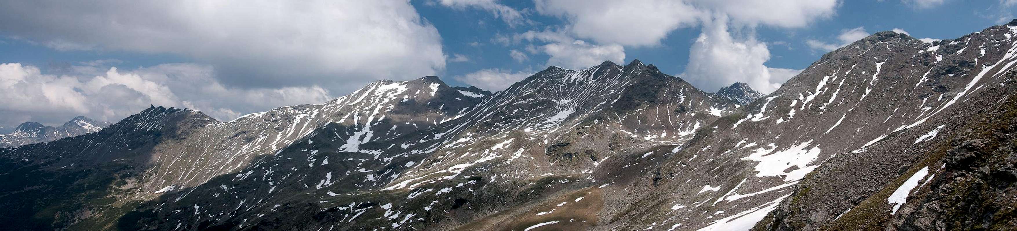
 Jakobspitze seen from Tagewaldhorn
Maps & Books
Maps
- Digital Maps
- Regular Maps
- Sarntal/Val Sarentino
Kompass Map WK 056
1:35.000
ISBN: 3-85491-340-0
- Brixen / Bressanone
Kompass Map WK 56
1:50.000
ISBN: 3-85491-063-0
- Bozen / Bolzano
Kompass Map WK 54
1:50.000
ISBN: 3-85491-061-4
- BOLZANO-RENON / BOZEN-RITTEN-TSCHÖGGLBERG
Tabacco Map 034
1:25.000
- MONTE SARENTINI / SARNTALER ALPEN
Tabacco Map 040
1:25.000
- Sarntal/Val Sarentino
Books
- Bozen-Salten-Schlern
Kompass Guidebook WF953
Kompass Verlag
ISBN: 3-85491-406-7
- Rund um Bozen
Helmut Dumler
Rother Verlag
ISBN: 3-7633-4267-2