
|
|
Canyon |
|---|---|
|
|
41.06900°N / 111.88904°W |
|
|
Hiking |
|
|
Spring, Summer, Fall, Winter |
|
|
Overview

Adams Canyon Route Map

Primitive Bridge across Holmes Creek


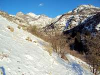
Adams Canyon (sometimes called North Holmes Creek), located near Hwy 89 in Layton is an extremely popular hike into the canyon, through the forest and up to a 40 foot waterfall. In the evenings during the summer, there is upwards of 50 people on the trail and pretty much everyone in Layton Utah has climbed Adams Canyon at least once.
That being said, there is good reason for its popularity. First, it is difficult enough to be challenging without being brutal. Secondly, the hike through the canyon is a beautiful example of Northern Wasatch forest. Finally, seeing the waterfall is a statisfying reward for the effort.
This 3.8 mile round-trip hike can be accomplished year around, although it can get a little sporty in the winter with light scrambling, sloughing through drifts, and steep trails covered in ice sheets. Fall trips up the canyon feature some pretty spectacular color changes while spring shows off nice wildflowers. The forest portion of the hike is fairly cool in the summer but the lower portion going up to the Bonneville Shoreline Trail is a sandy, sun swept series of switchbacks which generally makes that part of the trip fairly unpleasant during high summer. Bring water!
The hike to the waterfall is broken up into three segments. From the Trailhead to the Bonneville Shoreline Trail (sandy switchbacks), from the BST to river crossing (pleasant forest hiking), from the crossing to the waterfall (rocky trail and light scrambling). All total, it is 1.93 miles trailhead to the waterfall with a 1,420 foot elevation gain.
GETTING TO THE WATERFALL
From the trailhead parking lot proceed up the sandy switch backs. There’s only one trail from the trailhead, so it’s impossible to miss. This portion up the west face of the hill is hot and dry. After about .6 mile, you will reach Bonneville Shoreline Trail (BST). The trail will split left, up, or right. Go right, into the canyon for another ¼ mile and the trail splits again. The right branch crosses a bridge, continues South on the BST to Kaysville and, ultimately, Provo 90 miles to the south. DON’T CROSS THIS BRIDGE!
Continue on the left fork into the canyon forest and enjoy the hike for another .6 mile until your reach a primitive bridge--a large log with boards nailed on to it. Cross the bridge (or ford the stream) and continue following the trail. At this point the trail becomes kind of confusing as hundreds of people have chosen different methods of going toward the waterfall. Simply follow the path that looks closest to you hiking skills staying along the creek and heading “up”. After .3 miles you will cross the creek again (during the Spring you will get your feet wet, plan accordingly). The waterfall is on your right! Enjoy the view and retrace your trip up back to the trailhead. Hardcore, in shape people do Adams round-trip in less than 1.5 hours, average hikers in around 2. If you haven't been working out, plan on 3 hours.
Hike Details:
Main Trailhead: Adams Canyon Trailhead (41.066216,-111.909978)
Distance: ~3.8 Round trip
Vertical Gain: ~1,420 Feet
Hike time: ~2+ hours
Hazards:
Just because everyone in Layton Utah has climbed Adams Canyon, it is not totally safe. The most common hazards are slips, spills and falls. The trail is rocky and steep in areas. Spring is a especially hazardous as the trail in the canyon is an ice sheet. Wear crampons or yak tracks. Talking with the search and rescue people, they make about 4 trips a month up the canyon to rescue people.
Allow your self plenty of time and/or bring a flashlight. I see a lot of people starting their hikes at sunset without any provision for being stuck in a dark forest.
Bring plenty of water; it's a short trail but it is a hot one in the summer.
Wildlife hazards are primarily in the form of rattlesnakes. Bugs are negligable but DEET is always advised.
Getting There

The trail gets rocky in places after the crossing the bridge

From I-15 take Exit 330. Proceed toward S. Main Street, merging onto S. Fort Lane. Turn right at East Gentile Street and continue onto Oak Hills Drive. Turn Left onto US 89 N. Take a right on N. Eastside drive (Near Cheveron and Grounds For Coffee). Take another right at the T (Past Grounds for Coffee) and follow N. Eastside Drive to the trailhead at 41.066216,-111.909978
The parking lot is a large dirt lot with spillover parking on the side of the road. It has room to accomadate horse trailers. Most mountain bikers avoid Adams Canyon (sandy switchbacks make for a really hard ascent!) but do bike the BST from Fernwood to Kaysville.
Red Tape
None. No fees or permits required because Adams Canyon is on National Forest Service land. Campfires are prohibited during the summer due to high incidence of forest fires (you can see the scars from the last fire all through the area). Dogs should be leashed. Horses and mountain bikes are permitted. No motorized vehicles are allowed on the trails.
Camping

Camping spot after bridge
There are a half dozen good places to primitive camp along the river trail. The first one is located in the mouth of the canyon just inside the forest, 4 sites along the creek, and one more good site after crossing the primitive bridge. All of these spots are near North Holmes Creek so un-purified water is available. Since Adams is more of a day hike, at least one of them are usually available.
External Links
https://www.summitpost.org/adams-canyon-north-ridge/164098https://www.summitpost.org/adams-canyon-t-h/comments/333929
http://www.localhikes.com/Hikes/AdamsCanyon_7160.asp
http://www.trails.com/tcatalog_trail.aspx?trailid=HGS542-006