
-
 6766 Hits
-
 89.01% Score
-
 28 Votes
|
|
Mountain/Rock |
|---|---|
|
|
38.93917°N / 110.45402°W |
|
|
Hiking, Trad Climbing, Scrambling, Canyoneering |
|
|
Spring, Summer, Fall, Winter |
|
|
6065 ft / 1849 m |
|
|

Overview
Without a doubt, one of the greatest road sights in America, if one of the least trumpeted, is the jagged uplift of the San Rafael Swell, specifically the San Rafael Reef, as one drives west from Green River on I-70. Suddenly, a tortured landscape rips into the sky, and if you are driving at dawn, the reds of the rocks may make you think that you are witnessing a snapshot of Hell.
What is the San Rafael Reef, and is it different from the San Rafael Swell?
The Reef is part of the Swell. Specifically, the San Rafael Reef is the eastern edge of the San Rafael Swell, and it is notable for its rugged appearance.
More, from an interpretive sign along I-70:
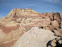
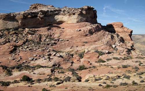
The San Rafael Swell is "a large anticline where the earth's crust has been heaved from below to form a great dome of rock layers. Erosion, over millions of years, has erased the top of the dome. Imagine a rainbow with a rough and ragged flat top where every band of color is revealed. Here, at the eastern edge of the anticline, erosion has sliced and sculpted the steeply tilted layers of hard sandstone. Slot canyons, spectacular pour-offs, sheer cliffs, and miles of desert varnish remain."
Also according to that interpretive sign, the collection of peaks, ridges, and domes on display at the first rest area west of Exit 149 is known to locals as the Silent City. Other interpretive signs tell about the construction of the road through Spotted Wolf Canyon, which cuts through the San Rafael Reef here, and about the area’s mining history.
 |
 |
 |
 |
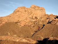
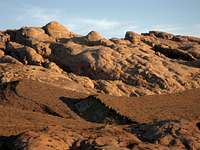
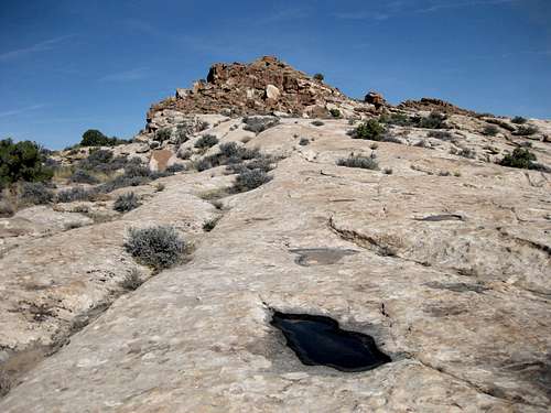
The Silent City is a maze of pinnacles, ridges, domes, washes, and dead-end canyons, and getting to any particular peak is not such a simple matter. Frequently, washes end at impassable pouroffs, sandstone slopes become too steep to traverse, or a promising ridge suddenly ends at a drop of hundreds of feet. What on the map or from the parking area looked like a promising route may turn out to be a trip to a dead end. Unless you are just randomly roaming about, expect to have to backtrack and try a different course more than once. Come out here prepared; although the high peaks along the crest of the Silent City are no more than two straight miles from the parking area, with about 1600’ of elevation gain tops, plan on spending at least twice the amount of time you normally would to cover such an outing. And be ready for climbing conditions to change from Class 2 to Class 5 almost instantaneously.
The highpoint of this complex is a 6065’ peak marked simply as “Dragon” on the USGS Spotted Wolf Canyon Quad. Presumably, the name refers to the proximity of Black Dragon Wash, where there are pictographs by ancient Native Americans high on a canyon wall, including one figure that resembles a dragon. As far as I could tell, reaching that summit requires Class 5 climbing, but my wanderings out here did not take me to that peak (for why, see the next paragraph). I am, though, fairly certain that reaching the base of that summit can be done via no worse than Class 4 climbing, maybe as easy as Class 2. This is based on visual observation only.
 "Dragon Peak"
This page covers the location in general but does not tell you how to reach the highpoint. Although “Dragon” was my goal when I set out, I ended up on several other peaks, including 5830 AT (where my GPS device actually gave a reading of 5861'), just northeast of "Dragon," instead. By the time I identified a good way to reach “Dragon” (and I mean the peak, not the summit itself), I was in “return” mode and didn’t think I could make the summit, anyway, because I could not see anything that looked “easy” Class 5 or below that went up to the top.
Since this page does not focus on “Dragon,” it is my hope that someone else who has climbed the peak will add it here either as a mountain or route page.
 |
 |
 |
 |
Getting There
Park at the rest area just a couple miles west of Exit 149 on I-70. The peaks are in your face. Head out to them, climbing over a barbed-wire fence; after crossing that fence, the players are just you and the desert.
Another easy way to know that you are at the right location is to look for a cross memorial to Utah Highway Patrol Trooper Dennis "Lee" Lund, who died in 1993 after being shot by a teenager fleeing the scene of a gas theft in Thompson Springs (more details).
Red Tape and Camping
As much as possible, avoid stepping on the biological crust.
There are no campgrounds nearby, but dispersed camping is widely available along local 4wd roads.
